historyofwandsworthcommon.org›Trinity Road›References for the talk
Last modified: 3 November 2026
IN PROGRESS — NOT FOR PUBLICATION
Trinity Road
A Short History of a Long Road
References for the talk, November 2026
The text of the talk
Every link has been checked. Most go to your own site (Chronicles months, the unpublished /roads/trinity-road/ drafts, the Elam albums); the rest to listings and other published sources. quotable marks a good line or story for the talk; to check something stated but not yet verified, or where your sources disagree; lead an inference of mine.
Your own drafts and series already written · Origins and names · Dead straight for almost two miles · Through the Common, and defining it · Stopping at North Side, and the extension to the Thames · The motorway that never was · Churches · Pubs · Public buildings and transport · The Prison · The Royal Victoria Patriotic Asylum for Girls · People and houses along the road · Events and memories · Images and maps for slides · Other published sources · Gaps worth closing before the talk
Your own drafts and series already written
Start here: much of the talk is already drafted on the site, mostly unpublished.
- Trinity Road: A short history of quite a long road (in progress, not public). Your running notes: measurements, early names, the curve at North Side, planning blight, land swaps, and Louise Murphy’s 273-word draft for WC150 (July 2020). Decade pages: 1930s (the 1937 LCC scheme, with the Fulham Chronicle text and map), 1940s (Abercrombie), 1950s (Ringways links and the GLC file), 1960s (the Balham Loop) and 2000s (empty).
- The Proud City: A Plan for London (1946): full transcript of the Ministry of Information film.
- Highways across the Common, your three-part series: Part I, April 2026 (the second Wandsworth Bridge, the 1937 scheme, “Big Problems need Big Solutions”); Part II, May 2026 (Abercrombie 1943, The Proud City, “A Glimpse at the Wandsworth of the Future” 1949, the Balham Loop); Part III, June 2026 (the transformation of 1968–72, planning limbo, the French Horn & Half Moon, the Unitarian Chapel, “Four hundred homes, seventy shops”, the Common lost and found). These three are close to a ready-made second half of the talk.
- Chronicles, December 2025 (part 1): the “ghost road” to Tooting, distinct from both Trinity Road and Bolingbroke Grove, and your open question: “I would love to know when exactly Trinity Road was built, and indeed why?”
Origins and names
When the road was made, by whom, and what it was called. Your sources disagree on the naming date (see the last point).
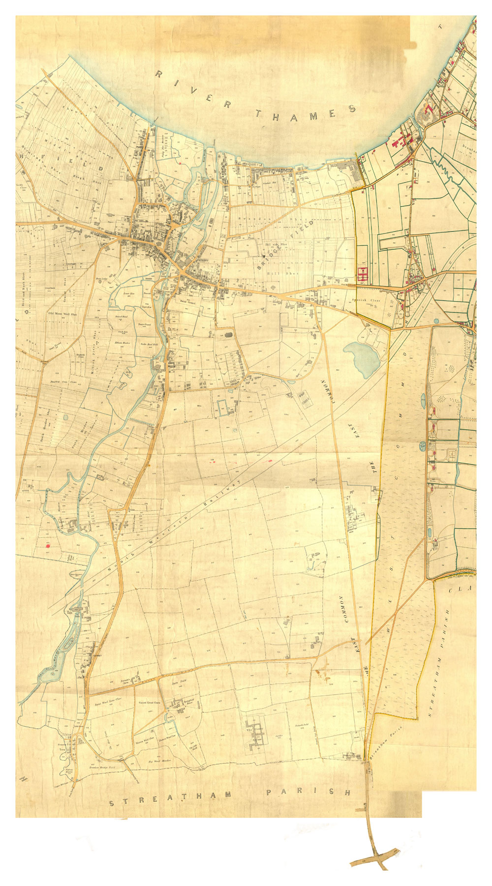
- Maps. Rocque 1766 shows the obstructing lake at the north end; then Corris 1787, Mylne 1800, OS Old Series c.1810, the tithe maps of the 1840s and Stanford 1862. On the site: A History in Maps; Corris, Wandsworth, 1787, with Book of Reference; Faden, 1790–1819; Batten, 1827; the tithe maps. (Four of the map images linked from your draft page now give “not found”: Rocque, Corris, OS Old Series and Stanford.)
- In 1802 a mare was stopped “in the lane leading to the Wheat Sheaf, at Tooting”: the southern end of today’s road. Chronicles, July 2022 quotable
- In 1802 the Manor Farm sale covered the land between St Anne’s and West Side, “part of which was then the future Trinity Road”. Chronicles, September 2021
- In 1825, according to the Survey of London draft, the Battersea Bridge proprietors and the 2nd Earl Spencer got parish approval for a new 25 ft road “leading from Trinity Road northwards across the common”: the future St James’s Drive. Survey of London, “Between the Commons” (draft) The name is probably the Survey’s, not of 1825, but the date bears on when the straight road existed. to check
- In 1869 the Wandsworth District Board of Works ordered both sides of “the road on Wandsworth Common” to be planted with black Italian poplars (Clerkenwell News, 24 September 1869). Today the northern end has limes, and the Scope section old planes. Chronicles, September 2021
- Early names. “Wandsworth Lane” on the map of Holy Trinity and its environs, c.1870 (Chronicles, February 2022); Tooting Lane, Wandsworth Lane, “Wandsworth & Tooting Lane” and Wheatsheaf Lane (your draft page). The OS of 1868 shows the northern section as Trinity Road and the southern as Wandsworth Lane (Louise Murphy’s draft; and “the recently named Trinity Road shown in pink”, Chronicles, December 2022).
- Named after Holy Trinity, Upper Tooting (consecrated 26 June 1855): Chronicles, July 2025 (part 2), “Trinity Road and Holy Trinity Church”. to check The dates conflict: July 2025 says “probably around 1860”; April 2026 says “not called that until the 1870s”; the OS of 1868 already uses it for the north end; your draft says “c.1870”. Worth settling from the Post Office directories and the census before the talk.
- In the rate-book and boundary story, the old Battersea–Wandsworth boundary ran almost straight across the Common, its southernmost point near today’s junction of Trinity Road and St James’s Drive. Chronicles, July 2025 (part 1)
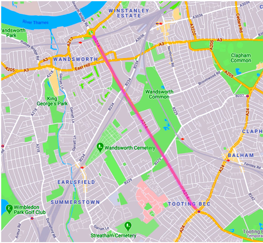
- Road numbers. Today the road is part of the A214 (Wandsworth to West Wickham). Wikipedia: A214; SABRE: A214. Your draft’s questions “Part of B253 (when?)” and “Part of A214 (1930s?)” are still open: SABRE’s history tab is the place to look. to check
Dead straight for almost two miles
Material for the road’s most striking feature.
- Measurements (your draft page): about 300 m from Tooting Bec to Glenburnie Road, where the straight starts; about 2,700 m from Glenburnie Road to North Side; about 800 m from North Side to the roundabout. Total 3,800 m, about 2.4 miles. The old road, Tooting Bec to North Side, was “just over 1.8 miles”.
- “Its straightness is a sure sign of a completely new road, built across a no-person’s land”: compare wandering Garratt Lane, Burntwood Lane and Nightingale Lane (your draft page). quotable
- Velocipede race, April 1869: the “straight, level two-mile course”, won by M. de Ferne in 10 min 30 s (South London Press, 24 April 1869). Chronicles, April 2022 and Chronicles, December 2024; the cutting is also on your draft page. quotable
- “Trinity Road is so long and dead straight — almost two miles — that it was often used for races”: pedestrianism (walking and running matches). Chronicles, September 2021
- Cycle racing and club rides: “the dead straight Trinity Road (almost 2 miles long) — was regularly used for cycle racing”. Chronicles, January 2023
- Paper-chases and cross-country runs, 1888–89, finishing with “a straight run of about a mile” down Trinity Road. Chronicles, December 2022
- A dog race, “Davison’s Legs v Palmer’s Fly”, 1871: along Trinity Road? Chronicles, August 2022
- A serious bicycle accident: a cyclist thrown by a runaway horse on Trinity Road, 1897. Chronicles, November 2022
- Military route marches “six abreast” along Trinity Road. Chronicles, January 2022
Through the Common, and defining it
How the road cut the Common in two, and how it shapes the Common today.
- Contemporary objections, in your draft page: the road divided the Common; it was hard-surfaced; there were no pavements, so pedestrians were threatened by speeding vehicles; ratepayers would have to maintain it; and roads brought houses right up to their edges. quotable
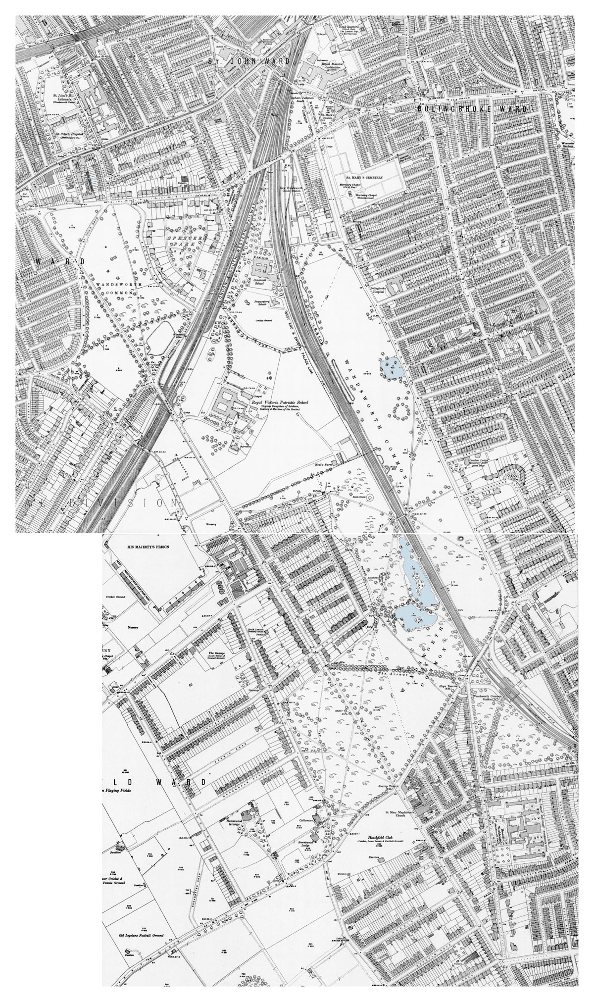
- The kite-shaped enclosure for the Patriotic Asylum, “defined by two sharply converging/diverging railway lines, the future Trinity Road” and a straight boundary. Chronicles, July 2022
- “The Common was at its smallest in 1868, today it’s 20 or so acres larger. A strip was lost when Trinity Road was ‘dualled’ in the late 1960s, but patches were found here and there to compensate”: the Prison Banks, and an acre in the Patriotic Building grounds. Chronicles, May 2025 quotable
- The swerve at North Side. A lake made the road veer west for its last hundred yards; the bend is now the top of West Side, “by-passed when the dual carriageway was constructed… a bit like an ox-bow lake”. Chronicles, September 2021 Also your draft page (Rocque, Corris, Mylne). quotable
- McKellar’s Triangle, the 20-odd acres between Trinity Road, Bellevue Road and St James’s Drive, bought from Earl Spencer in 1848–53. Chronicles, June 2022; The McKellar family (new page, not yet uploaded).
- The Prison Banks: half of the Patriotic Fund land in front of the prison was “restored to the Common around 1969, when the northern section of Trinity Road was made into a dual carriageway”. Chronicles, June 2022; Chronicles, August 2023.
- Trinity Fields, the former Common at the Burntwood Lane corner: Trinity Fields: all pages (with Graham Jackson).
- Lightning on Windmill Road: the people killed were “under the thirteenth tree from the former road”, i.e. from Trinity Road. Chronicles, June 2023
- The Avenue, between the Hope and Trinity Road: the ghost of a cricket boundary? Chronicles, April 2023. A memorial bench there: Chronicles, March 2026.
- Unhelpful land added to the Common: the verge between the County Arms and the railway bridge, Marcilly Road “dug up and grassed as a ghost road”, and continuing worry about a roundabout at the Surrey Tavern crossing (your draft page).
Stopping at North Side, and the extension to the Thames
Why the road went nowhere for a century, and how it was finally pushed through.
- “Until the late 1960s, it stopped abruptly (and somehow senselessly) at North Side, well short of the Thames. Was it originally intended to lead to a new bridge?” Chronicles, December 2025 (part 1); also Chronicles, April 2026. quotable
- The first Wandsworth Bridge. The company was incorporated in 1863 (Evening Standard, 21 November 1863); the bridge opened in 1873; it was narrow (30 ft), weak, lost money, and was made toll-free in July 1880. Chronicles, November 2022
- The 1937 LCC scheme. “Wandsworth Bridge to Wandsworth Common: County Council’s Costly Scheme”: £845,000; dual carriageways; cuttings under East Hill and North Side. It called Trinity Road “a very well aligned road leading in the direction of Wandsworth Bridge… a gap of less than 600 yards” (Fulham Chronicle, 30 July 1937). Your 1930s page; Chronicles, April 2026. quotable
- The Royal Commission on Cross River Traffic (1926) recommended a better approach. The LCC began reserving land in 1939 (GLC file). The new bridge was built by Holloway Brothers and finished in September 1940, delayed by steel shortages. Chronicles, November 2022
- The 1960s scheme. In June 1966 the GLC upgraded the underpass to dual three-lane, with a wide central reserve for a future flyover, on the assumption that Trinity Road would be widened “similarly”. roads.org.uk archive: GLC/DG/PTI/P/05/075, Wandsworth Bridge Southern Approach, 1965–69; MT 118/379.
- “The widening and extension of Trinity Road, the digging of the canyon-like underpass, and the construction of an enormous ‘Squareabout’… were begun in 1968 and completed in 1972.” It cost about £4 million. A Wandsworth Council paper of November 1967 records the clearance of “400 dwellings and seventy shops”, compared with the 1,750 homes at risk from Ringway 1 in Battersea, which caused an outcry. Chronicles, June 2026 quotable
- The opening of the new road, Fulham Chronicle, 27 February 1970: “a direct link between the bridge and Trinity Road with a roundabout at the intersection with York Road”. Chronicles, February 2023
- What was lost: Huntsmoor Road, “utterly demolished when the Trinity Road underpass was driven through it” (Chronicles, September 2024); the French Horn & Half Moon; the Unitarian Chapel on East Hill, which “narrowly escaped”; and a Bramford Road memory of the traffic queues before the extension (Chronicles, June 2026).
- The No. 19 bus turned off for Clapham Junction; Fulham was hard to reach; and “How different things would have been if Trinity had continued across the river” (your draft page). quotable
- Also by the river: the “dual carriageway was constructed from the County Arms down to the river”, and the havoc it caused on the Windmill Road bridge. Chronicles, July 2023
- Nigel Black, “The curious tale of Wandsworth’s motorways”, Wandsworth Historian no. 106 (2018): the authoritative article, cited in June 2026.
The motorway that never was
Proposals to turn Trinity Road, or the Common beside it, into a trunk road or motorway.
- Hansard, 26 November 1937: a Liberal MP proposed “a great road running from Hampstead right across to, probably, Wandsworth Common, 300 feet wide and with trees down the middle”. Chronicles, November 2021 quotable
- Abercrombie and Forshaw, County of London Plan (1943): the Wandsworth Bridge approach to Trinity Road at Windmill Road, and the “C” Ring Road connecting “Trinity-road (at its junction with Burntwood-lane) with Atkins-road”. Chronicles, May 2026; your 1940s page.
- The Proud City (1946): transcript. “A Glimpse at the Wandsworth of the Future” (1949): Chronicles, May 2026.
- Planning blight in the 1950s and 1960s. “Everybody on the west side of the Common believed that Trinity was going to be dual-carriagewayed all the way from St Leonard’s at Streatham”, with the County Arms and the houses demolished (your draft page). A derelict 197 Trinity Road, photographed in the late 1960s, opposite Hardy’s house. Chronicles, May 2026 quotable
- The Balham Loop. The “LCC Suggested Motorway Pattern” of the early 1960s ran a motorway across the Common along the Balham–Clapham Junction railway, meeting the M23 at Tooting Bec Common. Your 1960s page (with the map); Chronicles, May 2026; roads.org.uk: Balham Loop.
- Ringway context: South Cross Route; Clapham–Wandsworth link; post-war planning; Wikipedia: London Ringways.
- What survives: the A214 is a three-lane dual carriageway between Wandsworth Roundabout and Dorlcote Road, the stub of a road “intended to be part of the London Ringways”. Wikipedia: A214
- The Heathfield Avenue lime avenue to the prison gates was cut short by the dualling: “Inside v. Outside. Dark v. Light. Captivity v. Liberty… all that engineered symbolic power was lost.” Chronicles, April 2024 quotable
Churches
Three are identified below; I could not find which church you count as the fourth.
- Holy Trinity, Upper Tooting, which gave the road its name: by Anthony Salvin, 1854–55, tower by Benjamin Ferrey 1860; Kentish rag; Grade II; “at an angle to the Trinity Road junction”. Listing 1226162. Geoffrey Bevington’s photograph, c.1864, and the Macmillans as worshippers: Chronicles, July 2025 (part 2). The National Schools on either side of the road (one demolished 1959) and Hardy’s skating pond: Chronicles, February 2022.
- St Mary Magdalene, Wandsworth Common: by E. B. Ferrey, 1888; Grade II (listed 2004) as an “unaltered late-Victorian church”. Listing 1391164; London Church Buildings. On the site: the rood screen war memorial (Chronicles, November 2023); Canon Theodore Wood, naturalist vicar (Chronicles, February 2022; Chronicles, June 2023); “pillaged five times in the course of a year”, 1911 (Chronicles, December 2022); the Trinity Jazz Club, R&B in the church hall, 1960s (Chronicles, October 2024); bomb damage (Chronicles, October 2024); the cope on display (Chronicles, October 2025 (part 2)).
- Trinity Road Chapel, 205 Trinity Road. searchchurch. Your own memory of the Life Boys there: Chronicles, March 2025 (part 2). Its date and denomination are still to find. to check
- The fourth? Possibly a church just off the road, or one now gone. to check
Pubs
- The Wheatsheaf, Tooting Bec, at the south end: the 1802 “lane leading to the Wheat Sheaf” (Chronicles, July 2022); rebuilt in 1892 (Louise Murphy’s draft; to check); and the landmark for the 1869 velocipede race (Chronicles, April 2022).
- The County Arms, 345 Trinity Road (Young’s): in the Post Office Directory of 1855 (William Finch); “County Arms Hotel” on the OS of 1868; livery stables in 1878. pubwiki; pubology. Elam postcard “County Arms and Gardens”, with signs for “Illuminated Gardens” and “Concerts” (Elam Album 7). You, aged four, waving a flag outside it for the Queen, 9 June 1953 (Chronicles, June 2022). quotable
- The Surrey Tavern / Surrey Hotel, now Brinkley’s, at the Bellevue and Burntwood Lane crossing: adverts (Chronicles, April 2022); a sports pub (Chronicles, December 2021); orientation on the enclosure map (Chronicles, March 2022); Paul Martin’s moonlight photograph in snow, 1896, a 40-minute exposure (Chronicles, December 2023; Chronicles, November 2025 (part 2)). Several postcards in Elam Album 1, including “Surrey Tavern Wandsworth Common 24.8.1947”. quotable
- The French Horn & Half Moon, at the north end: demolished for the 1968–72 scheme, having been demolished once before c.1900 for a road linking Trinity Road and East Hill. Chronicles, June 2026
- Shops on the road: a butcher “just round the corner in Trinity Road”, and 27–29 Bellevue Road with slaughterhouse. Chronicles, May 2023
Public buildings and transport
- Tooting Fire Station, Trinity Road, Upper Tooting: 1907, LCC Architects’ Department (Fire Brigade Section); Arts and Crafts; inscribed “London County Council Fire Brigade 1907”; Grade II, “one of the best examples of the LCC fire stations built between 1896 and 1914”. It replaced an 1868–69 station on Balham High Road. Listing 1266001; Historic England. quotable
- The police station. “The Old Police Station, 1a Trinity Crescent”, just off the road, is marketed as “a former Victorian police station” (Savills). 1 Trinity Crescent is Grade II, “late C19”, with a stable block (Listing 1357663): probably the same building. lead Your note on “houses named after police leaders” may connect: is Henderson Road named after Sir Edmund Henderson, Commissioner 1869–86? lead
- Trinity Road tube station, opened 1926 on the Morden extension, renamed Tooting Bec on 1 October 1950. Chronicles, October 2025 (part 1); Tooting History: Trinity Road station.
- A railway station “near Trinity road” was petitioned for by 500 residents in 1914 and refused, with fears that buses down Earlsfield Road “would cause the houses to fall down”. Chronicles, May 2023
- Railway bridges: the cutting with the Trinity Road and Heathfield Road bridges, and an unbuilt line meant to “pass in a cutting under Trinity Road (more or less where Routh Road crosses now)”. Chronicles, January 2025
- Trinity Fields Board School and the encroachment of 1883–84: The Board School encroachment.
- No. 107: the Institute of Trichologists (your draft page). to check
- The sewer aqueduct runs “in a straight line just north of the Trinity Road railway bridge, past the Patriotic Building”. Chronicles, August 2024
The Prison
- Opened in 1851 as the Surrey House of Correction, for 1,000 prisoners; “the approach from Trinity Road along the now lime tree-lined Heathfield Avenue”. Chronicles, September 2025 (part 1)
- Henry Mayhew’s rail journey to the prison in the mid-1850s. Chronicles, August 2025 (part 2)
- The land between the prison and Trinity Road was bought by the Surrey justices as a cordon sanitaire, with covenants against building. Chronicles, January 2023; Chronicles, August 2023
- Heathfield Avenue: the avenue of limes cut short by the dualling. Chronicles, April 2024
- Conkers: “In Trinity-road, which is bounded on one side by Wandsworth Gaol, and on the other by the Common”. Chronicles, September 2023 quotable
- Neal’s Nursery between the prison and the road; “Fitzhugh Estate, Trinity Road” view, c.1960. Chronicles, August 2023; The Neal family (new page).
- Elam postcards of the prison gatehouse along the tree-lined drive: Elam Album 8.
The Royal Victoria Patriotic Asylum for Girls
- Queen Victoria laid the foundation stone in 1857 (Illustrated London News, 25 July 1857, with the prison in the background). Chronicles, July 2023
- Your RVPA pages: The Royal Victoria Patriotic Asylums; for Girls; McNeill Ritchie; for Boys (Slater).
- The high iron railings along Trinity Road, and the great wall at right angles to it. Chronicles, October 2025 (part 2)
- Aerial photographs of 1947 (Trinity Road, the Toast Rack and the RVPA, before the Fitzhugh “skyscrapers”): Chronicles, August 2022. Later aerial views, and access to the schools “only ever from entrances on Trinity Road”: Chronicles, May 2024.
- Many postcards, including the 1907 royal visit: Elam Album 7.
People and houses along the road
- Thomas and Emma Hardy, 1 Arundel Terrace (“The Larches”, now 172 Trinity Road, at the Brodrick Road corner), 1878–81, where he wrote A Laodicean. They moved in on 22 March 1878 (Chronicles, March 2022); the 1938 photograph (Chronicles, January 2022); “troubled at night” (Chronicles, November 2021); the monster with “four million heads and eight million eyes” and the view from the house (Chronicles, May 2022); his illness from 23 October 1880 (Chronicles, October 2021); Alexander Macmillan’s parties at Knapdale (Chronicles, July 2025 (part 1); part 2); and reciting poetry on the Common, May 1881 (Chronicles, May 2026). quotable
- David Lloyd George, at what is now 166 Trinity Road, before 3 Routh Road. Chronicles, January 2024
- “The Beeches”, corner of Patten Road: the Wilson family; demolished in the 1970s? Chronicles, January 2024 to check
- Wandsworth Lodge, with “a frontage of nearly 1000 feet to Trinity road (the main road from Wandsworth to Tooting)”, and its clearance sale of 1885. Chronicles, May 2022; The de Selincourt family (new page).
- Dr Arthur Thomas of Trinity Road and the starvation inquest of 1893. Chronicles, September 2022
- Your parents’ last home, Chesham Court, Trinity Road. Chronicles, April 2024
Events and memories
- 9 June 1953: the Queen and Prince Philip drive along Trinity Road after the Coronation. Chronicles, June 2022 quotable
- The Second World War: V-1 craters on the Scope by Trinity Road (Chronicles, September 2024); barrage balloons on Trinity Fields and the Cricket Pitches (Chronicles, October 2024).
- The new Trinity Road underpass opens, 1970: Chronicles, February 2023. Excavating the underpass, c.1969, and “there’s just before, and there’s after”: Chronicles, June 2026. quotable
- “In the 1880s, the recently-named Trinity Road was tranquil and unpaved. The boy with his barrow has no idea what’s coming.” Photograph of the top of Trinity Road and West Side. Chronicles, June 2026 quotable
Images and maps for slides
Other published sources
- Nigel Black, “The curious tale of Wandsworth’s motorways”, Wandsworth Historian 106 (2018).
- Graham Gower, Balham Heritage Trail (Streatham Society, 2010): Knapdale and the Upper Tooting end.
- Survey of London, Battersea draft chapter, “Between the Commons” (Bartlett/UCL): online copy.
- Chris Marshall’s roads.org.uk Ringways history: index; and the roads.org.uk archive of GLC and Ministry files.
- SABRE Roads wiki: A214, with numbering history.
- Historic England listings: Tooting Fire Station; St Mary Magdalene; Holy Trinity.
- Graham Jackson, A History of Trinity Fields (2021).
Gaps worth closing before the talk
- When was the straight road across the Common made, and by whom? Earl Spencer in the 1800s–1820s is the likeliest. Check vestry minutes and Spencer estate papers around 1802–25.
- When was the name “Trinity Road” first used? Your pages give c.1860, “the 1870s” and c.1870, but the OS of 1868 already has it. The Post Office directories for 1855–78 should settle it.
- The road numbers: when was it the B253 (if it was), and when did it become the A214?
- Which is the fourth church?
- The police station: dates, and whether it was 1 Trinity Crescent.
- The date of the Wheatsheaf rebuild, and of the North Side lake’s drainage.
Build 3.