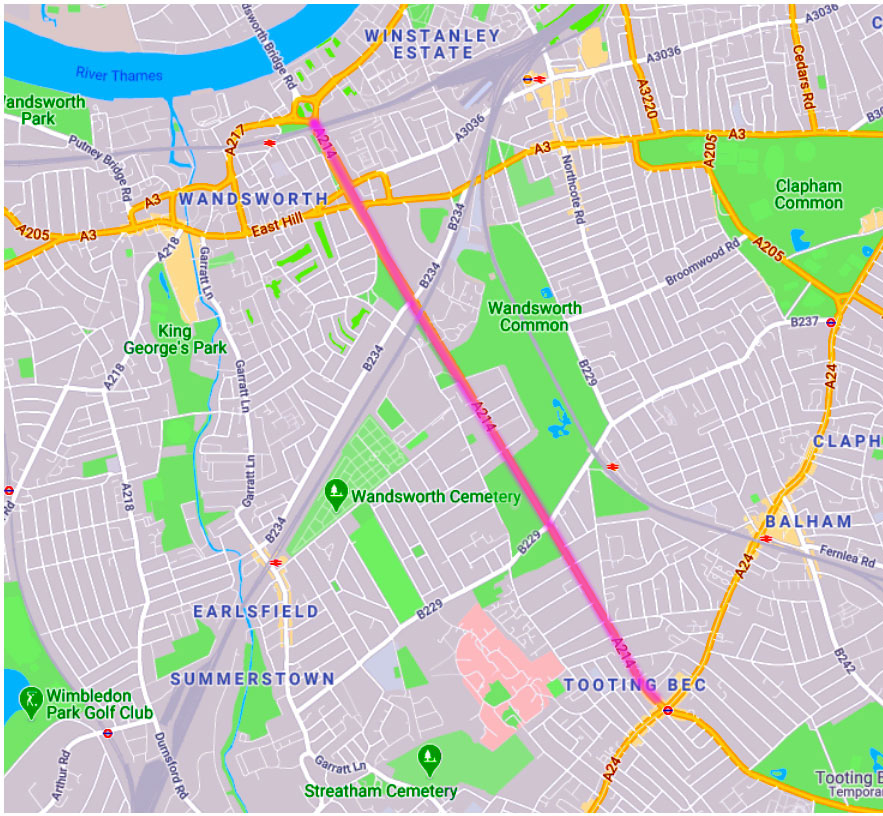
[Probably best to discuss the development of the road itself - the direction, size, length, width, surface etc - separately from the features (buildings, sideroads, Common) on either side.]
NB Originally nearly all of it ran through the Common, with common land on either side... see e.g. Rocque. Show on old and modern map.
NB integrate as many pics as poss, including from the London ? archive
— 1930s
— 1940s
— 1950s
— 1960s
— 2000s
— The Proud City (1946)
and houses after police leaders
https://www.google.com/maps/place/107+Trinity+Rd,+London+SW17+7SQ/@51.4382998,-0.16303,15z/data=!4m6!3m5!1s0x487605dd9bc13e05:0xbd3760819aefcb76!8m2!3d51.4382998!4d-0.16303!16s%2Fg%2F11bw4czgnl?entry=ttu
This is how I remember it - as the serious-sounding "institute of Trichologists", which it's been for many many many years, I think.
I've got an idea that, as such, it was run by the father of somebody I was at school with, David Salinger (himself now an internationally-renowned, er trichologist).
I've emailed Keith. Fingers crossed.
All best
Philip
PS
And now?
"The Institute of Trichologists is the foremost professional association for Trichologists in the World, the largest provider of Trichology training in ... "
10 Harley St, London W1G 9PF
https://trichologists.org.uk/
________________
Prof. David Salinger | AATRI
www.aatri.org › professional=david-salinger
Take a look at Trinity Rd on any map of south-west London. Notice how unusually long and dead straight it is. Compare it with wandering Garratt Lane or Burntwood Lane or Nightingale Lane. Or indeed anywhere else on this map. Its straightness is a sure sign of a completely new road, built across a no-person's land where there were no particular topographical challenges such as rivers or steep hills.
Above all there was little or no property in the way — no houses, no gardens, no fields. It was cut across Wandsworth Common at the orders of the lord of the manor, Earl Spencer [date?] — except for a short narrow curved section in the south near Tooting Bec, an older road in Streatham parish, which Spencer did not own. (There's also a fascinating curved section at the north end, where the road meets east Hill/North Side, that veered westward to avoid a pond.)
- about 300m from Tooting Bec to Glenburnie Rd, where the straight section starts
- about 2700m from Glenburnie to North Side
- about 800m from North Side to the roundabout and the foot of Wandsworth Bridge
Total: 3800m = just over 4000 yards or 2.4 miles
Wheatsheaf Lane (Tooting Bec end — from the Wheatsheaf pub to Glenburnie Road) [ map? date?]
Tooting Lane, Wandsworth Lane, Wandsworth & Tooting Lane
etc
Officially named in 187? (just after Thomas Hardy moved in)
When Thomas Hardy moved to No? Trinity Road in 18?? he tells his friends that he has moved to
Part of B253 (when?)
Part of Ringway 1 (B? C?)
Part of A214 (1930s?)
We may take the road for granted now, but (along with the railways) the building of it was experienced in the C19 as itself a loss to the Common — that it divided the Common — that unlike tracks — desire lines — that wander and naturally evolve it was dead straight — it was hard-surfaced — there were complaints that pedestrians were threatened by speeding horse-drawn vehicles because there were no pavements — that it would fall to ratepayers to maintain it
Today, we would add pollution and noise and physical danger.
Hmm, I wonder how many acres Trinity Road covered then — and of course it's a lot more now.
And of course roads bring houses and people, right up to the roads — land by the side of the old tracks was the first to be encroached upon and enclosed and made private property
The first few hundred yards of "Wheatsheaf Lane" — which became Trinity Rd c1870 — from the crossroads at what is now called Tooting Bec — was (and still is) an old narrow curving road, lined with houses and shops - a bit too tight and busy with trafic to encourage much "gentrification".
This part was in the old parish of Streatham. But as soon as the route reached the border with Wandsworth/Battersea — and the Common itself — it divided into wandering tracks — desire lines — and it was these that were rationalised/formalised by Spencer into dead straight roads — later called Trinity and St James's — one straight on, the other at an angle
etc etc
NB these tracks across the manorial waste — the Common land — there were no responsibilities to keep them up in any way — probably muddy, rutted, etc etc
Furthermore Trinity, having gone dead straight for a mile or so — across open land — there was no Prison or RVPA, of course — and only crossed a railway line in 183? — before swerved westward to avoid a lake at North Side (drained c. 18??) — came to an abrupt end.
It really didn't really go anywhere.
Presumably there had been an expectation that the road might lead across the common fields to a new toll bridge but this was frustrated by the recalcitrance of the many disparate owners — unlike the Common, which Spencer could dispose of largely unchallenged
The toll bridge was not built until c.1870 and it was a puny affair, attracting little traffic — and in effect nationalised — and made free — a few years later.
And so it remained until the 1960s
How different things would have been if Trinity had continued across the river
When I grew up, we hardly ever travelled across the river to Fulham and beyond — we certainly didn't support Fulham or Chelsea football clubs — partly because they were on the rival side of the river, but also because they were so awkward to get to
This difficulty remains
The No 19 bus from Tooting Bec turned sharp right and went down to Clapham Junction and then into Battersea and central London
It's much the same today
Detailed plans were made in the 1930s involving digging an underpass, but thanks to the war nothing happened until the late 1960s
[Abercrombie et al's plans for Wandsworth in the 1950s and 1950s? Say more. Show maps]
In the 1950s and 1960s everybody on the west side of the Common believed that Trinity was going to be dual-carriagewayed all the way from St Leonard's at Streatham
Which meant that the County Arms and the all of the houses along Trinity would be destroyed — there was a distinct sense of planning blight
Were we wrong in our suspicions/expectations? It would be good to know.
However In the late 1960s a partial dual carriageway was built, but only from the County Arms onwards, which meant further loss to the Common
But by the terms of the 1871 Act and subsequent acts, land lost to the Common had to be replaced — indeed, apparently there was a small overall gain
But welcome as it is, much of the land tacked on to the Common is not particularly useful — nor even recognised as part of the Common
- a width of grass between The County Arms and the widened railway bridge, with a few trees and some planted "wild" flowers
- the ends of gardens behind Heathfield Cottages [or whatever they're called now) made into a playground
- Marcilly Rd — dug up and grassed as a ghost road
[And these?]
- a tad of land in the RVPA's grounds [?]
- a narrow strip opposite the Battersea Cemetery along Bolingbroke [?]
- other?
The anxiety about further losses to the Common persists today, with concern about a roundabout envisaged at the old Surrey Tavern — the Trinity-Bellevue-Burntwood crossing

Trinity Road
A north south road or track linking Upper Tooting with the settlements of Wandsworth and Battersea, running across Wandsworth common, has probably been in use for centuries. However the evidence from historic maps varies its precise location and direction, and the name used, throughout the eighteenth and early nineteenth centuries. Tooting Lane, Wandsworth Lane or indeed Wandsworth & Tooting Lane appear on various maps of the period.
The road as we know it today is shown on an Ordnance Survey map of 1868 with the northern section named Trinity Road and the southern section Wandsworth Lane. Trinity Road was adopted after Holy Trinity Church was built in the 1850's. The northern section linking Trinity Road to Wandsworth Bridge wasn't completed until 1970.
Until the mid nineteenth century the road ran almost entirely through fields and common land but with the growth of public transport and the rapid expansion of the south London suburbs, houses were built piecemeal on either side of Trinity Road, as the adjoining land was developed in the 1880's and 1890's. The southern section saw construction of terraces with small ground floor shops & businesses, such as tobacconist and grocer, with residential floors above, while further north the houses became more substantial.
The growing population required amenities and by the end of the century Holy Trinity and St Mary Magdalene churches and the Trinity Road Chapel had been built. The Surrey Tavern and the County Arms were built during the 1860's and the Wheatsheaf, at Tooting Bec, was rebuilt in 1892. The underground station originally called Trinity Road opened in 1926 and didn't become Tooting Bec until 1950.
273 words
The curve at the top end, where the old Trinity Road meets Northside and East Hill
YES, Trinity Rd did come right up to Ivy House — a great westward swerve, still there today
See e.g
The bend was already there in the 1840s — notice also the Black Sea
And you can see why on the first OS map c.1810 (also Mylne 1800):
There was a big lake there (but NO LAKE where the Black Sea was soon to be formed), later drained
You can see it on Corris 1787 — and what might be a house and garden to the west of it:
And the obstructive lake is really clear on Rocque 1766:
e.g. another view in 1862:

(Click on image to enlarge)
South London Press — Saturday 24 April 1869
Two wheels good, four wheels bad
[NEEDS EDIT]
Velocipede Race on Wandsworth Common
Wednesday a race took place with now fashionable recreation of velocipede riding on a level road on Wandsworth Common, between six amateur velocipedians, for stake of £15 distance was two miles, and two of the competitors, who travelled with two-wheeled machines, were handicapped, and put 25 yards below the starting point The other four, who contended with the old fashioned four-wheel velocipede. started level.
The race was commenced at a sharp pace. Mr. Canton (four wheels) finishing the flret mil Tin five minute# and seconds, ami commanding good lead spirited race was kept up. the riders the two-wheel velocipedes working easier than their opponents; and when within half mile the winning point a French gentleman (M. Feme) a two-wheeler came from the rear, passed his opponent*, and won by several lengths. The last half-mile was covered two minutes and seconds, and the two miles accomplished the winner minutes sod seconds.
[Source: Link]
A241
- Wikipedia: A241 road
- Sabre-roads A214
The A214 is a road of two halves in south London. It starts off very grandly as a small part of the Ringway 1 scheme and is a primary route until we reach Streatham. Strangely, this section of road was only Class II in 1922 (as the B233) and did not become part of the A214 until the 1930s.
We leave the roundabout with the A217 and A3205 just to the south of Wandsworth Bridge and take the dual carriageway (Trinity Road) under the London to Ascot railway. Next we pass under the only grade separated junction [PB: meaning?] on the A214 with the A205 South Circular and climb up the hill where we pass over several series of lights with the B234 [?]and the B229 [?] and pass over the mainline from Waterloo to the West Country. Over to our right is Wandsworth Prison and to our left is Wandsworth Common. By now Trinity Road has become a traffic-clogged S2 [meaning?] and at Tooting Bec we reach the junction with the A24. The Bec part of the name comes from an abbey in Normandy of the same name who were lords of the manor.
Notes from NatureScope pdf, 2012 or thereabouts?
The Wandsworth Bridge Southern Approach Road
Sir Patrick Abercrombie's County of London Plan of 1943 proposed a series of ring roads around the capital. The South Circular was to be the 'C' ring (the third ring out from the city centre) but a new road did not materialise and the route was assigned to existing roads through the southern suburbs. The Greater London Council revived the issue and proposed a new south circular road from the foot of West Hill across King George's Park and the St Anne's area to Trinity Road and to a major roundabout on the southern part of the Common. This again was shelved, but a new road from the 1943 plan connecting Wandsworth Bridge with the redesigned Trinity Road was eventually built.xliii
See also Folder 1 E for Shirley Passmore's history:
'As early as 1937 there was a plan to build the Wandsworth Bridge Southern Approach Road (the Underpass). It was intended to turn Trinity Road into a dual carriageway from Wandsworth Bridge to Balham. An Act of Parliament was passed in 1938 to allow this to happen. The plan entailed taking a great swathe of the common for the extra road width and the LCC looked to see where it could find suitable exchange land.
The 8 acres in front of the prison, now leased to Neal's Nursery garden, was an obvious choice. The LCC had tried in 1890 to get possession of it from the Home Office, referring them to the restrictive covenant. They had failed but had acquired from Earl Spencer the manorial rights to prevent building. The 1924 LCC Parks publication said "It is improbable the the Home Office contemplate building on the land... but the situation needs watching and the most strenuoius opposition should be offered if ever an attempt is made". However, all plans for the new road came to a standstill in 1939 with the outbreak of WW2... In 1964 the road plans were resurrected. A new Act of Parliament (repealing the 1938 Act) was passed for the purpose. The plan now was limited to a dual-carriageway as far as the County Arms.
The Home Office parted with half of the land in front of the prison in a long strip parallel to the road. Other exchange land was acquired by reducing the length of the gardens of Heathfield Gardens. These cottages had been compulsorily acquired with the intention that they be pulled down and all the land made into common. However, public outcry and national publicity at the proposed loss of this attractive row resulted in just their gardens being taken. To make up for this, that part of Marcilly Road that crossed the common from North Side was removed (an avenue of trees now indicates where the road once was). Work on the Wandsworth Bridge Southern Approach Road (now fortunately just an extension to Trinity Road) began in 1966/7, and was officially opened in March 1970. It had cost under budget at £4m.'
Ghost Road — St Anne's Road/Marcilly Road (part)
Off to the east [say more?], you can see the largest of the Common's "ghost roads", marked by an avenue of old trees. It has had several names, including St Anne's Road and latterly Marcilly Road. The road and pavement were dug up and the surface re-grassed at the end of the 1960s when Trinity Road was made into a dual-carriageway. (By the terms of the Wandsworth Common Acts, any land lost from the Common had to be added from somewhere else.) The new underpass and one-way system meant Marcilly Road was easily disposed of. Today, you would hardly know it had ever existed.
BRESSEY REPORT ON SOUTH CIRCULAR 1938
Brief ref:
"The London County Council are seeking powers in the present Session to construct the length of approximately half a mile between Wandsworth Bridge and Trinity Road as part of the Wandsworth Bridge scheme, which, if Parliament give the necessary powers, will receive a grant of 60 per cent. "
https://api.parliament.uk/historic-hansard/written-answers/1938/jul/20/bressey-report
See also
https://www.roads.org.uk/ringways/early-plans