Added
IN PROGRESS — PLEASE SEND COMMENTS
A brief history of
BELLEVUE ROAD
in maps
Rocque, mid-1700s
It is difficult to relate all of John Rocque's routes to modern roads, except in a general way. But the track that will give rise to Bellevue Road is clearly shown wandering north-eastward across the Common from Burntwood Lane (named, left) towards the future Nightingale Lane (not named, right).
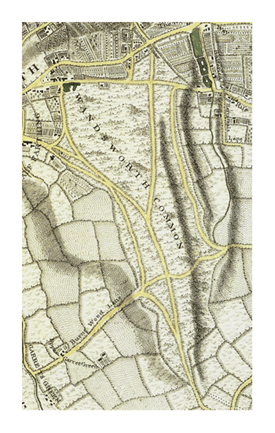
Is Rocque faithfully representing what he mapped, within the limits of the techniques available to him and the need to get the job done fast? Or is it largely impressionistic?
(Click on image to enlarge)
Corris, 1787
The ur-Bellevue is not shown at all on the Corris maps of Wandsworth and Battersea in 1787 - the track must have been insignificant at this time. However, the (approximate) route of the future St James's Drive is indicated by parallel dotted lines.

Corris 1787, Battersea, with approx. positions of future Bellevue and St James's Drive marked. Corris shows ur-St James's, but no path or track even roughly corresponding to Bellevue.
Notice, incidentally, Earl Spencer's encroachments (outlined in red) along the future Bolingbroke Grove.
See also the "Ghost Road" crossing and re-crossing the parish boundary - it is not the future Trinity Road. The parish boundary and the "ghost road" would have emerged more or less exactly half way between the future Wiseton and Althorp Roads [today's building numbers 22 and 23? [23 and 24? Check].
[Later [date?], the parish and parliamentary etc boundary were shifted 20 yards or so slightly to run down the middle of Wiseton Road - see the 1950s map below - hence the former dead-straight parish boundary now has a little dog-leg in it.]
[Source: Wandsworth Common: Boundary markers.]
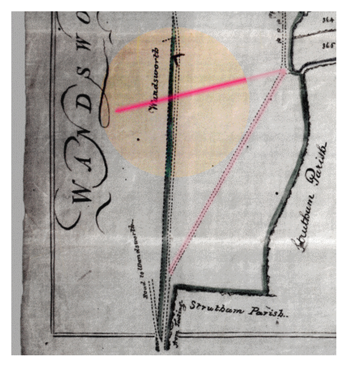

22 and 23 Bellevue Road: the "ghost road" along the parish boundary would have come out about here, between the two buildings.
Looking across the Common you might be able to see in perfect alignment the remaining parish boundary posts on the Avenue and on the corner behind the backs of the houses on Routh and Baskerville Roads.
(Click on image to enlarge)
Milne, 1800
The approximate route of the future Bellevue Road is indicated by parallel dotted lines on Milne 1800, though still as a simple rough track.

Notice also the northbound track that will become St James's Drive heading towards the bottom of Nightingale Lane as soon as the fields (bottom right) are cleared. (These are fields in Streatham Parish that Earl Spencer did not own - the field edges here relate to today's Boundaries Road.
Actually, not quite the course of St James's Drive - which will be built slightly to the west of this old track, probably to reach Five Houses Lane (Bolingbroke Grove) more directly. Notice also that the future Bellevue and St James's do not cross - they meet at the foot of Nightingale.
[Make animations?]
(Click on image to enlarge)
OS, 1808-1820

OS_Old_Series_1808-1820
The course of the future Bellevue and St James's is here represented rather differently from Milne. Travelling north-westward from Tooting, the track follows the parish boundary between Wandsworth and Battersea [hence may be part of what I've called the "Ghost Road" along the parish boundary travelling between Tooting and Battersea, or is it?] until it meets the future Bellevue, then veers slightly towards the Five Houses Road (the future Bolingbroke Grove). Very interesting.
(Click on image to enlarge)
Tithe maps for Wandsworth and Battersea parishes, c.1840
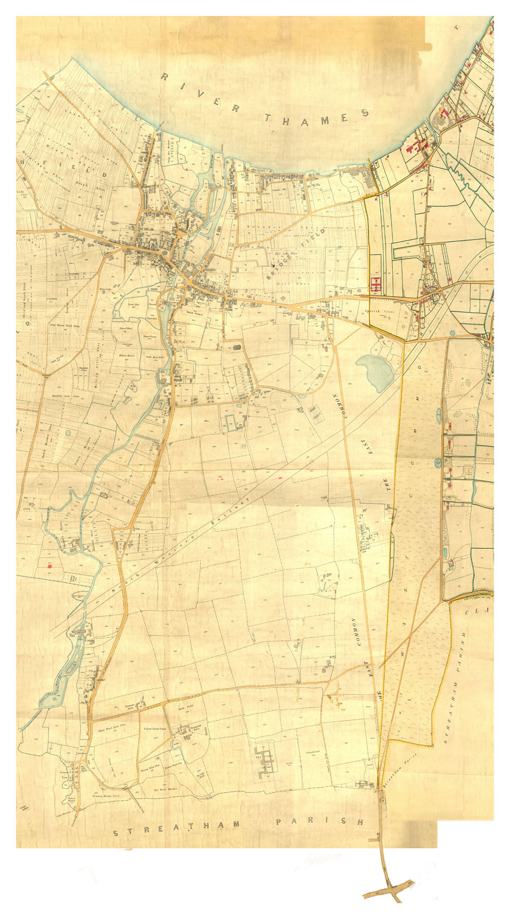
I have digitally combined the tithe maps for Battersea and Wandsworth. They do not meet exactly - indeed, although the route of Bellevue Rd is shown in Battersea, there is only a short suggestion of its future route on the Wandsworth side, and it does not connect with the top of Burntwood Lane [CHECK original maps]. Earl Spencer had built both Bellevue and St James's in the 1820s, so they are clearly shown [CHECK original maps].
Of course the railway line would not be in existence for another 20 years or more. Hence notice St James's crosses Bellevue and continues a few hundred yards over the Common before turning slightly to join the future Bolingbroke Grove.
(Click on image to enlarge)
Stanford, 1862

Stanford 1862 shows Bellevue as a straight road running between "Wandsworth & Tooting Lane" (called Trinity Road from 1868[date?]) to the junction of Nightingale Lane and the future Bolingbroke Grove.
(Click on image to enlarge)
The (as yet unnamed?) Bellevue Road is flanked on its southern side by a row of trees marking the boundary of McKellar's Triangle - but there are no houses. A railway interrupts St James's Road/Drive, but Bellevue itself is carried over the track by a bridge. At this point, there is no railway station. The area to the south ("McKellar's Triangle") appears to be a large undivided triangular field. ].
Once the railway appeared, both roads were interrupted - the roads no longer crossed but met and a bridge had to be constructed over the line. However, you can still see the course of St James's to the north of the crossing pint [where the Hope was built c.1865] - represented today by a short section of path on the Common (which then turns slightly to run along the railway line to today's lake - there was no lake here until the 1860s and later). For a while, this stub of the old road provided an access route for carts collecting gravel.
[The ?20-acre field formed by Bellevue, St James's Road/Drive Wandsworth & Tooting Lane (Trinity Rd) is often called McKellar's Triangle. McKellar had lived at Wandsworth Lodge, at the southernmost end of St James's Road, and acquired the land ... from Earl Spencer in [date?] ....He used it for agriculture but on his death...things changed very quickly...[FINISH].]
OS, 1868

OS, 1868
[The view over the Common was still mainly of furze bushes. But what a difference a decade has made to McKellar's Triangle. There are now roads crossing it, and of course numerous houses.]
(Click on image to enlarge)
OS 1869-1874

OS, 1869-1874
[The view over the Common was mainly of furze bushes.
(Click on image to enlarge)
OS 1894-1896, 60-inch
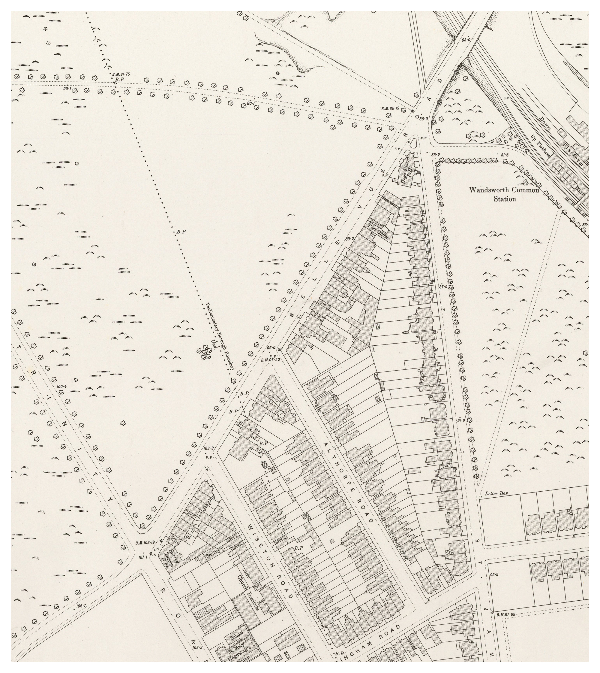
OS 1894-1896: this is the most detailed map we have - an extraordinary 60 inches to 1 mile.
Most of the shops and houses that we still see today have been constructed (or at least their descendants on the same plots), and (most of the) building numbers have been firmly established.
Where exactly was the abattoir on Wiseton Road? It looks as though it could have fitted into the large garden on the north side of Wiseton Rd, but in fact I think it was on the other side - behind where Sainsbury's Local is today.
(Click on image to enlarge)
OS 1945-55? [ADD INFO]
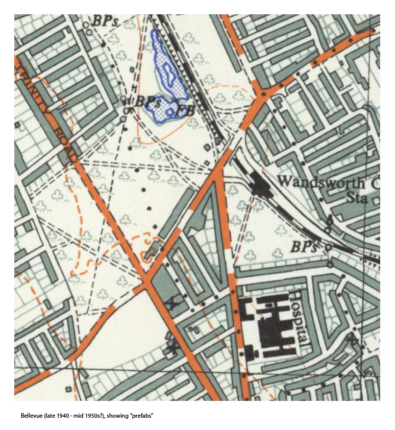

Bellevue, c. 1955, showing a row of "pre-fabs", number 35 to 65 (two unnumbered?), on the Common.
These had been built speedily to house some of the many people who had been bombed out during the war. Along with other prefabs on the edge of many parts of the Common, including nearby Bolingbroke Grove, they were demolished around [1955?].
[Notice the little dog-leg in the parish and parliamentary etc boundary at the corner of Wiseton Road - the dead-straight ancient [Anglo-Saxon] boundary ran 20 yards or so to the north - it passed between what are now ? and ? Bellevue.]
(Click on image to enlarge)
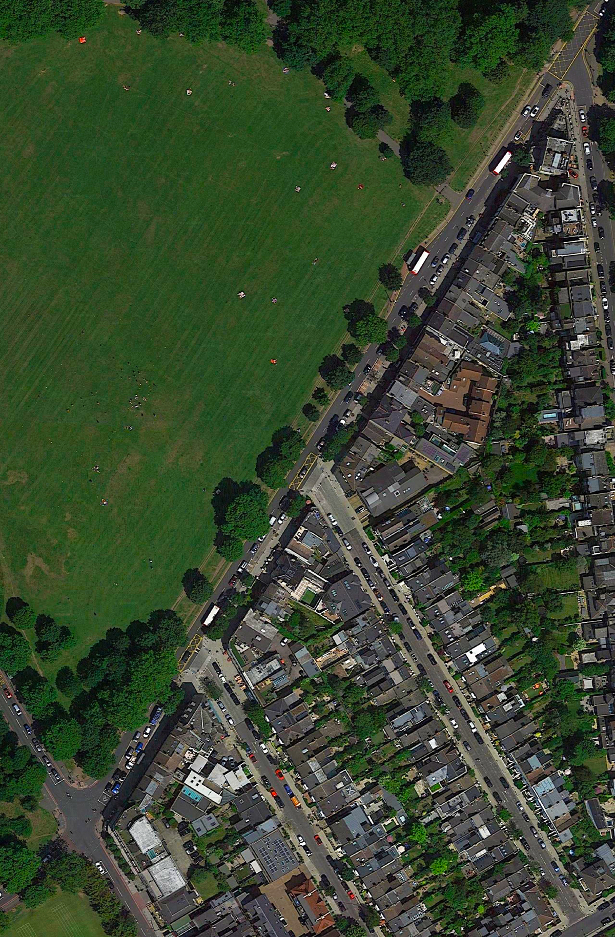
Google satellite view, probably June 2019
(Click on image to enlarge)
There is an even higher resolution version (c.9Mb) here
-
-->
. . . here is St James's Drive . . .
- 1 Bellevue Rd / The Hope Tavern
- Bennet Court
- 2 Bellevue Rd
- 3 Bellevue Rd
- 4 Bellevue Rd
- 5 Bellevue Rd
- 6 Bellevue Rd
- 7 Bellevue Rd
- 8 Bellevue Rd
- 9 Bellevue Rd
- 10 Bellevue Rd
- 11 Bellevue Rd
- 12 Bellevue Rd
- 13 Bellevue Rd
- 14 Bellevue Rd
- 15 Bellevue Rd
- 16 Bellevue Rd
- 17 Bellevue Rd
- 18 Bellevue Rd
- 19 Bellevue Rd
- Bellevue Garage
. . . here is Althorp Road . . .
- 20 Bellevue Rd
- 21 Bellevue Rd
- 22 Bellevue Rd
- 23 Bellevue Rd
- 24 Bellevue Rd
- 25 Bellevue Rd
- 26 Bellevue Rd
. . . here is Wiseton Road . . .
- 27 Bellevue Rd
- 28 Bellevue Rd
- 29 Bellevue Rd
- 30 Bellevue Rd
- 31 Bellevue Rd
- 32 Bellevue Rd
- 33 Bellevue Rd
- 34 Bellevue Rd
- 35 Bellevue Rd / once the Surrey Tavern
. . . here is Trinity Road . . .