This article was published by the Wandsworth Historical Society in The Wandsworth Historian, no. 58, Autumn 1989. It is transcribed here from a scan of the printed pages, with its four maps. Wording, spelling and punctuation are as printed. The original page numbers are shown in the margin, and the note numbers link to the notes at the end. Click a map to enlarge it.
The charter place-names Gower discusses are Rysmere, Leoddebeorge, Uckebyrge, Bernneardes Byriels and Blacan Mor (693) and Baelgenham (957). The Old English elements in them are beorg and byrge (‘barrow’, a burial mound), byriels (‘burial place’), mor (‘moor, marsh’) and, as Gower suggests, lēode (‘people’) or lād (‘watercourse’).
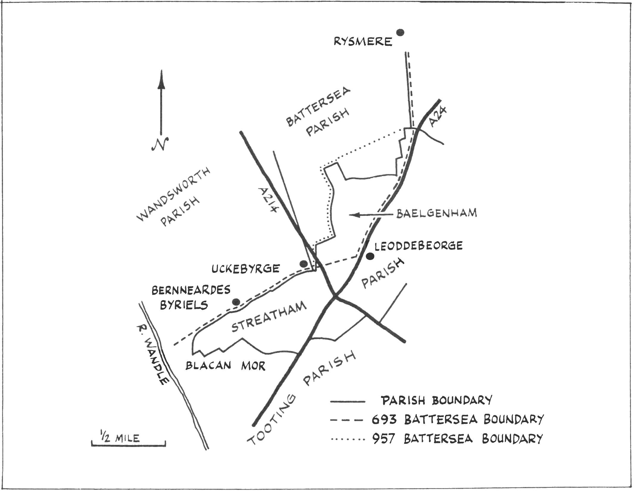
IN PREVIOUS ISSUES of The Wandsworth Historian, much debate has been given to the probable alignment/route of the Battersea boundary mentioned in charters bearing dates of A.D. 693 and A.D. 957 respectively, notably the section from Clapham down to the River Wandle. Most of these observations regarding this section have been, to a certain degree, viewed from the ‘Battersea side’ and the injection of new data, albeit limited, from the ‘Streatham side’ may well promote a further interpretation of this boundary, and may, to some extent, enhance our appreciation of the subject.
The boundary in question is referred to in two charters, bearing dates of A.D. 693 and A.D. 957, in which there is listed a series of boundary landmarks for Battersea. In the charter of 693 the landmarks that concern us are: Rysmere, Leoddebeorge, Uckebyrge, Bernneardes Byriels and Blacan Mor. In the later charter of 957, Leoddebeorge and Uckebyrge are omitted and replaced by Baelgenham (Balham). A brief discussion is tendered as to an alternative alignment/route for the Battersea boundary of 693 as it passed the western side of Streatham parish (Fig. 1).
On leaving Rysmere, a location considered to be on Clapham Common, the 693 [p. 10]boundary would perhaps have made a line for the summit of Balham Hill to join with the Roman road (Stane Street) from Clapham. On leaving the summit, the boundary followed the road, the present Balham High Road, to a place that appears to be of particular historical interest and known as Holiwelle. The site of Holliwelle lies approximately 300 yards (275m.) to the south of the junction of Ritherdon Road with Balham High Road. Here, until the middle of the last century, lay a cluster of ponds of which the larger, some 90 feet (27.5m.) in length, was commonly known as Hollywell Pond. Nearby, and injecting a little confusion into local place-name studies, was an area known as ‘Hollaways’ and also a number of fields and meadows of same or similar name1. Passing through this area, and most likely being the origin for the name Holloway, was a substantial watercourse, inelegantly called, during the last century, the York Ditch. This watercourse, which was a branch of the Falcon Brook, flowed from Tooting Common where it marked the parish boundary of Streatham with Tooting. On crossing Balham High Road by Ritherdon Road the ditch swung northwards on its progress towards the present site of Nightingale Square, Balham, and marked the western edge of an area known as Great Balams (16th century), otherwise called Cardinals Lease.
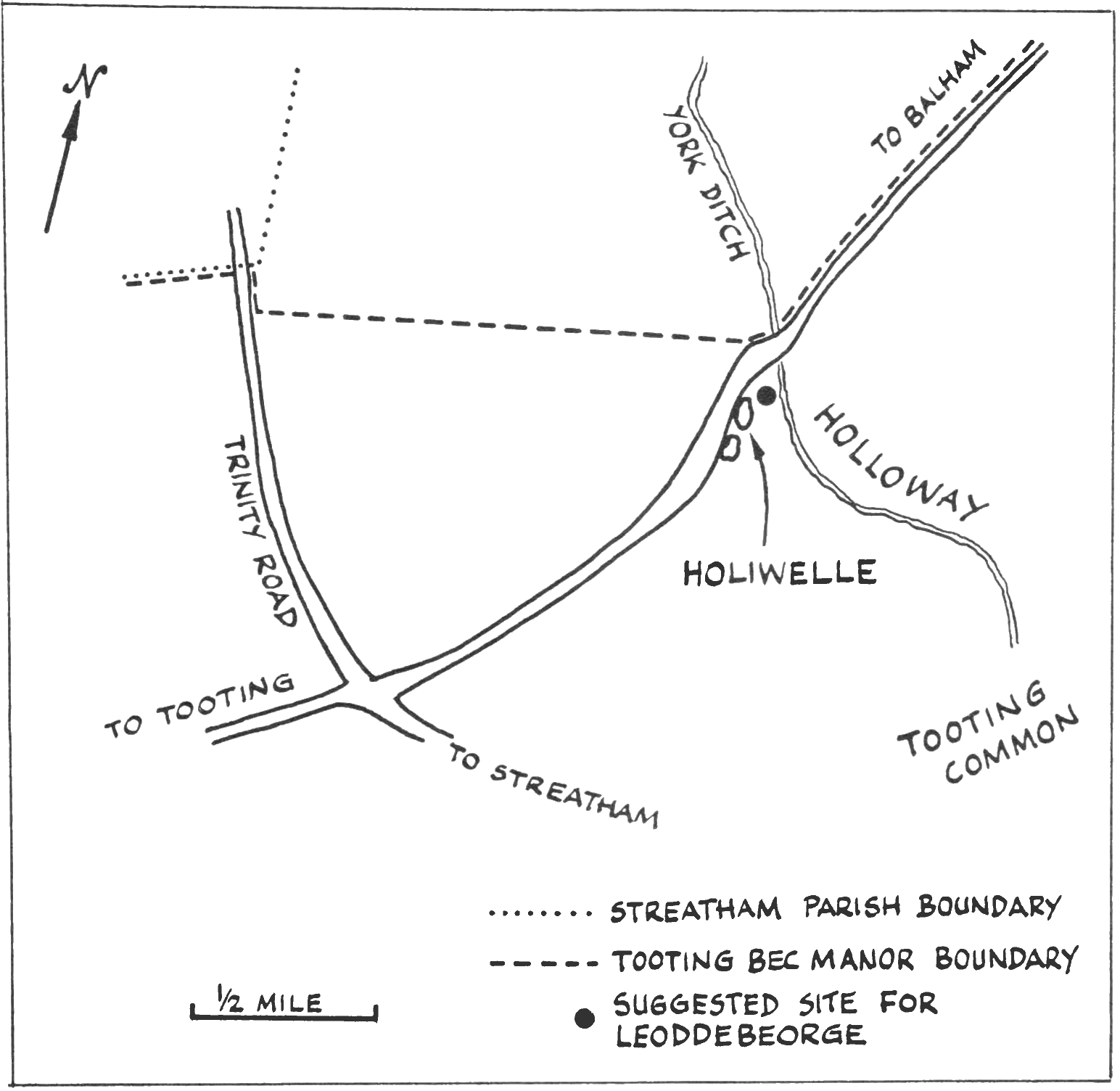
Considering the existence of the Hollywell ponds, which may have been the remnants of a larger feature, the nearby watercourse and the name Holliwell suggest that the place may have been a site of some local significance, especially when considering the pagan predilection for water deities and superstitions. If this should be the case, it is possible that the 693 boundary landmark Leoddebeorge could have been sited in this area; especially as the OE ‘loede’ element of the name refers to people, thereby hinting of a meeting place near or at a barrow, or perhaps by the ‘Holiwelle’ or ponds. Furthermore, one other interpretation for the name Leoddebeorge, tenuous as it may be, is that the element ‘loede’ could be a corruption of ‘lode’ being OE for watercourse. If so, we would have, in general terms, a ‘barrow by the stream’ in this instance (Fig. 2).
Whether the barrow or the other topographical features endowed the site with importance is unclear, but at this point along the road the Battersea boundary could have turned west, aiming for a contour point by Trinity Road, and giving us a possible location for the next landmark in the 693 charter list – Uckebyrge. Interestingly, the place name Baelgenham (Balham) is not mentioned in the charter [p. 11]list of 693, but is mentioned in the possibly revised list of 957. This suggests the possibility that Balham as a place or community did not exist in the 7th century. When the later list was compiled, Balham had been established and was therefore included, making redundant the need to mention Leoddebeorge and Uckebyrge. This implies that the boundary was radically altered by a move westward to accommodate the new settlement of Balham.
The name Baelgenham as used in 957 probably referred to the area later known as Great Balams which became part of the Streatham manor of Leigham Court. One of problems in understanding the early history and development of Balham is trying to establish exactly where Balham was. Current study seems to indicate that ‘Balham’ was a locality name, and not necessarily applicable to any particular spot until at least the late 17th century; although, it must be said, the manors of Tooting Bec and Leigham Court each enclosed an area [p. 12]called and considered to be Balham, whilst the Domesday Survey records a settlement there2.
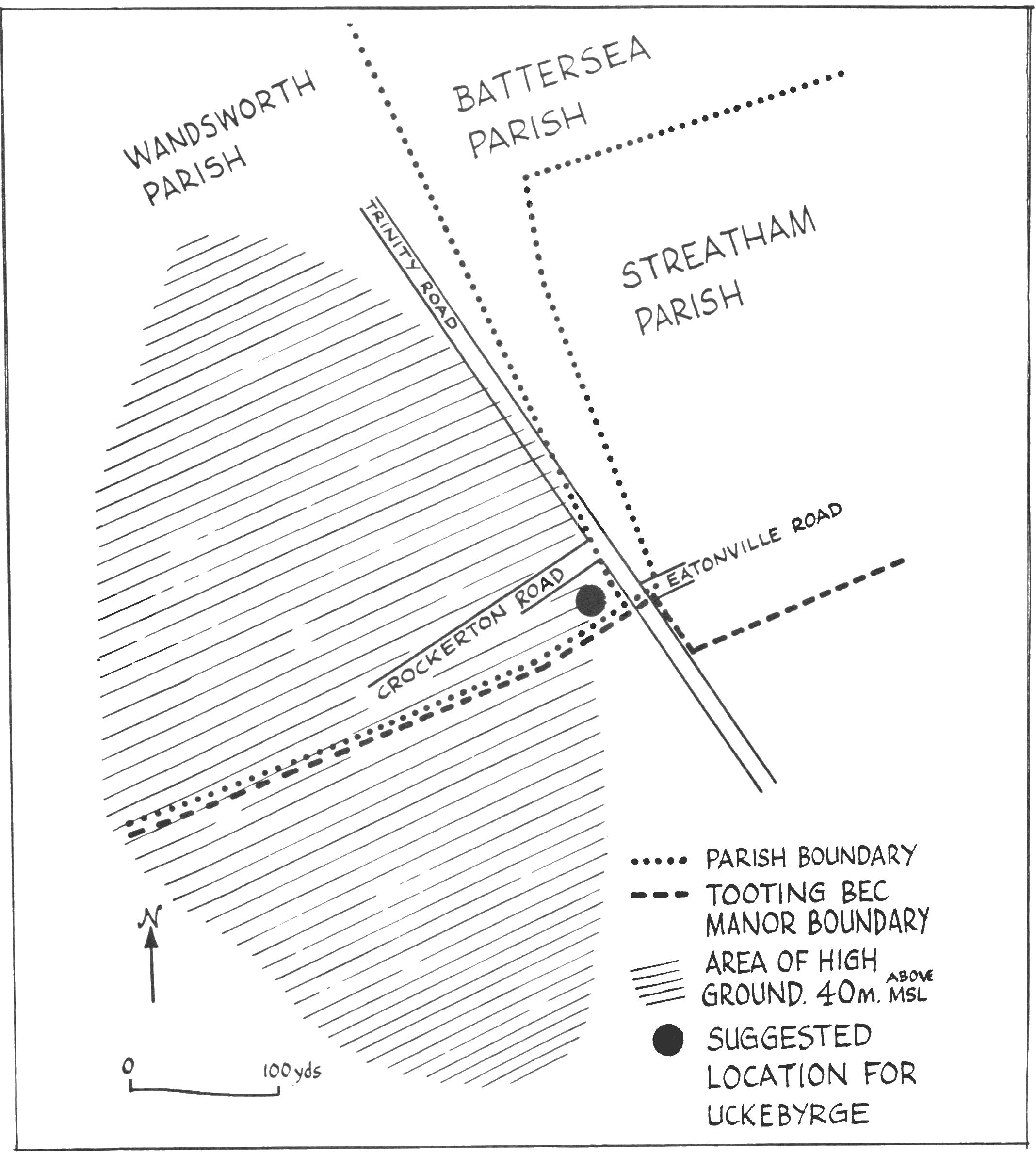
Following the same course as the suggested 693 boundary was the later manor boundary for Tooting Bec. This left Tooting Common at Dragmire Lane (Cavendish Road) and eventually joined with Balham High Road just north of Bedford Hill. Turning south and running with the main road, the boundary made a short detour to the west, around a minor salient into Cardinals Lease, before returning to the road and on to the York Ditch some two miles further south. From here, just north of Hollywell Pond, the manor boundary turned west away from the road, and in a straight line made for a point near the junction of Eatonville Road with Trinity Road, Upper Tooting, where the ground rises to some 40m. (130 ft) above msl. The Wandsworth – Battersea parish boundary was probably aligned on this particular area of elevated ground, which with the Streatham parish boundary converged on a point at nearby Crockerton Road (Fig. 3).
As suggested, this is a possible location for Uckebyrge and locates the barrow on elevated ground, thereby offering a landmark for the surrounding countryside. Furthermore, the route of Wandsworth Lane (Trinity Road) is of interest, as this aligns with the suggested site of Uckebyrge before continuing on through Streatham to the detached part of Battersea parish at Penge.
Returning to the 957 charter list, in which the place-name Baelgenham is first mentioned, the suggested revised boundary probably skirted round the new settlement of Balham back towards the Uckebyrge area. This new boundary later became, if it was not already at this date, the parish boundary for Streatham and for Clapham detached.
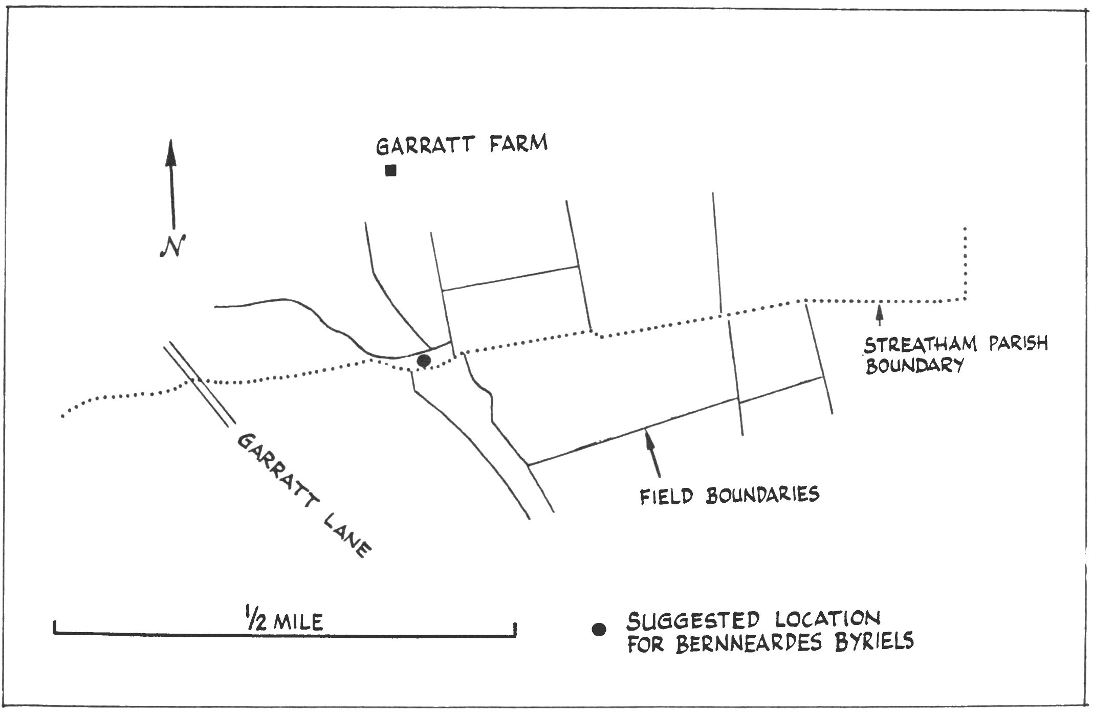
The next landmark to appear on both lists was Bernneardes Byriels. This has been suggested by others as being located along the alignment of the Streatham parish boundary as it descends from the high ground of Trinity Road towards the [p. 13]Wandle Valley. An observation of this section of parish boundary will reveal the directness of this route and also a curious elliptical indentation into Streatham parish, located midway along the course3. This feature (TQ270722), which borders Streatham Cemetery and lies opposite the site of Garratt Farm (17th century), could well mark the site of Bernneardes Byriels (Fig. 4). If so, it is interesting to note that the ‘burial’ was enclosed into Battersea parish and not Streatham. This is not surprising when considering that there is some evidence to suggest a later formation for Streatham parish than for the surrounding parishes.
Moving on from Bernneardes Byriels, the Battersea boundary continued to the next point on the lists – Blacan Mor. This area may have been across the south-west tip of Streatham Parish and may have given rise to a later place name – Blakmedowe (16th century). This meadow seems to have been located in the vicinity of Garratt Lane and was part of the post-Reformation estate of the Brook family of Upper Tooting. After Blacan Mor, the Battersea boundary continued towards the Wandle River and so on to a number of other landmarks, before completing the bounds of Battersea.
The stretch of boundary from Uckebyrge down towards Blacan Mor also marked the western extent of Tooting Bec manor, which along with the Streatham parish boundary, departed from that of Battersea at Plough Lane, Wimbledon. Turning south along the later line of the Surrey Iron Railway, this joint manor and parish boundary zig-zagged a course around Tooting Graveney parish before making for Streatham proper.
As is to be expected in such a synthesis, a number of questions arise. For example, no mention is made of the Roman road in the charter lists. This could be explained by a temporary decline in the road’s importance; although in a similar charter describing the boundaries of Lambeth, and attributed to A.D. 1062, there is written, ‘and swe est to thare strate’, a reference to Stane Street in the Kennington Oval area. Another question arises with the place name Pagingworth. This enclosure, or possible settlement, of which little is known, seems to have been located in the Balham area and the existence of such a place may well have had a bearing on local boundaries4.
Although the above is but a brief presentation of an alternative route for the 693 boundary, and a possible explanation for the later one, as they apply to West Streatham, it is evident that we shall never be completely sure as to their routes. Nevertheless, the western boundary of Streatham parish and of Tooting Bec manor, may shadow or reflect, to some extent, the ancient boundary of Battersea.
Notes
- There are various spellings for Holloway/Hollywell: Holiwelle 1312; Holewell 1398; Holywelle 1401; Holywelmede 1412; Holywellfeld 1447; Holywell Medowe 1589; Holloway Pond 1638; Hollowells Meades 1645; Hollywell Pond 1660; Hollaways 1706; Holloway Long Mead 1729. ↑
- There are a number of spellings for Balham, for example: Balsweyham, 1340, Leigham Court manor; Baloham, 1439, Clapham manor; Balwetham, 1448, Tooting Bec manor; ‘…arable lying within a parcell of land called Balams’, 1588, Tooting Bec manor; ‘messuage and land called Balhams’, 1701, Leigham Court manor. ↑
- The Benjamin Fallowes map of Tooting (1720) shows two field boundaries aligned to the north and south ends of this feature. On the 1839 plan of the Springfield Estate (Garratt Farm, Wandsworth Parish) three field boundaries also align to this feature, and one slip of land (1 rood 33 perches), lenticular in shape, covers the site. ↑
- Charter dated 7th. Sept. 20, Edw. II. (1326). Relating to lands in Clapham. (Calendar of the Close Rolls, PRO). ‘…3 acres of land in Pagingworth lying east and west (by) the high way on the north extending from the lord’s land to the common pasture of Totyng on the west…’ Also mentioned in this charter is ‘Grandunwell’ which is probably the same as ‘gryddeles elrene/gryndeled syllen’ of the 693/957 boundary lists. ↑
Sources
- K.A. Bailey, ‘Balham and Tooting in the Dark Ages’, Wandsworth Hist 40 (1984) 1–7.
- K.A. Bailey, ‘Battersea and Wandsworth in the Dark Ages’, Wandsworth Hist 45 (1985) 7–14.
- Bedford Estate Records (Greater London Record Office).
- D. Imber, ‘Excavations of Stane Street in the Clapham Area 1966–1971’, Trans London & Middlesex Archaeol Soc 25 (1974) 235–250.
- Map files at Wandsworth Local History Library and Lambeth Archive Department.
- Manor Court Rolls of Leigham Court (Lambeth Archive Department).
- Manor Court Rolls of Tooting Bec (Greater London Record Office).
- Ordnance Survey maps covering Balham, Streatham and Tooting, early editions.
- Streatham Parish Tithe Map (1840) (Wandsworth Local History Library).
- J.G. Taylor, Our Lady of Batersey (1925) Appx. A. Topography.
- T.M. Shore, The Archaeological Remains and Early Historical Associations of Streatham, Balham and Tooting (Balham: Balham and District Antiquarian and Natural History Society, 1903).