This article was published by the Wandsworth Historical Society in The Wandsworth Historian, no. 59, Winter 1990. It is transcribed here from a scan of the printed pages, with its five figures. Wording, spelling and punctuation are as printed; in the charter bounds the typescript’s overbarred ‘ae’ is shown as æ. The original page numbers are shown in the margin, and the note numbers link to the references at the end. Click a figure to enlarge it.
The passage on Battersea’s ‘long finger’ between Wandsworth and Streatham, and the suggestion that it encloses a row of prehistoric barrows (bernardes byrieles) on the high ground of Trinity Road, is on p. 9.
IN THIS DISCUSSION on the western boundary, the prime piece of evidence is considered to be the mention in the Domesday Book (1086) that in the manor of Battersea there were seven (water) mills with a value of £42 9s 8d, and also a toll (theloneum) to the value of £61. It is generally agreed that some of these mills must have been on the River Wandle2.
The Settlement called ‘Bridges’
The Victoria County History of Surrey (V.C.H.) discusses at some length a part of the manor of Battersea, ‘the important hamlet of Bridges (Brugges, Bregges) which extended along the river bank as far as the Wandle which was crossed by a bridge maintained by the Abbot of Westminster3’.
Further on, the V.C.H. refers to Bridges as being a ‘district’ and asserts that a reference to a tenement in a place of the same name held by Richard de Dol in 1225 (with other details in the 13th and 14th centuries including a descendent, Robert de Dol who died in 1355) cannot be [p. 5]conclusively considered to be the Battersea location4. However, the 1332 Surrey taxation return for Battersea (not quoted by the V.C.H.) not only lists ‘Robertus le Dol’ as having a rating of ten shillings, but also mentions a ‘Ricardus de Bregge’5.
The name ‘Bridges’ is peculiar word in that it is in the plural. If it had been in the singular, then the location of the settlement might be considered to equate with the bridge over the Wandle (see above).
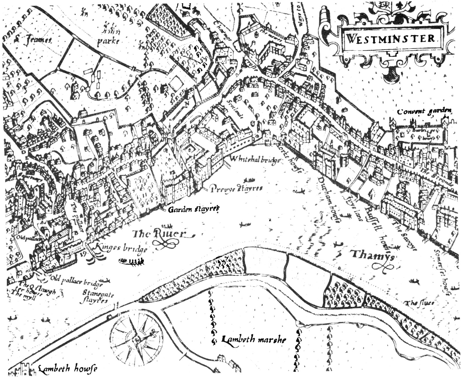
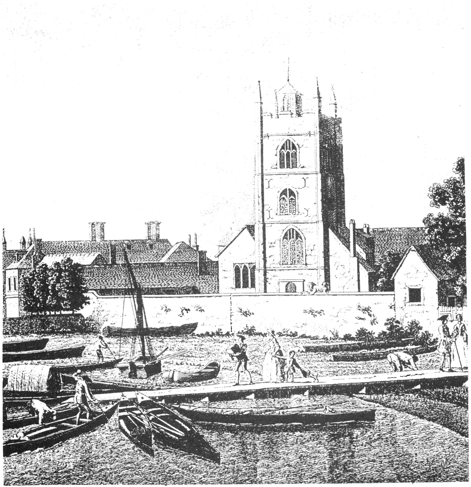
The answer to the problem seems to lie in the alternative meaning of the word ‘bridge’. In Middle English it also meant a wharf or jetty, which use continued into the post-medieval period and is still a dialect term today6. For example, John Norden’s 1593 map of Westminster shows three jetties with names including the word ‘bridge’, variously qualified (Fig. 1). Similar descriptions occur on Carrington Bowles’ 1780 plan of London, Westminster and Southwark7. Locally, as late as the 18th century there are references to the ‘Landing Bridge’ (1766) and the ‘Church Bridge’ (1768)8. These bridges – long [p. 6]sloping low-level jetties – allowed easy embarkation of people and goods whatever the state of the tide.
The Location of ‘Bridges’
In attempting to identify the location of ‘bridges’, early maps (Thomas Milne 1800, John Corris 1787, John Rocque 1741 and (the Wandle Valley only) Peter Gardner 1633) show not only the expected concentrations of settlement in Battersea (around the church and the square) and at the crossing place of the Wandle (Wandsworth High Street), but also in the area below the Lower Mill and immediately downstream from the Wandle mouth9.
[p. 7]Bearing in mind that it was not possible to navigate up the Wandle because of the mills across it, that the river valley was an obvious route into deepest Surrey (pace the later Surrey Iron Railway10) and that the products of the mills would need transportation to their destinations, the concentration of settlement at the Wandle mouth may be seen as representing the obvious transhipment area between river craft and road transport. Additionally, it may be noted that three of the four maps quoted above also show two recesses into the river bank just downstream from the Wandle mouth; these are presumably docks and Gardner depicts a boat apparently leaving one.
In this light and with the alternative meaning of ‘bridge’ in mind, the jetties, wharves and docks at the Wandle mouth may be seen as forming a small port which became known as ‘Bridges’. This interpretation is reinforced by Gardner’s map which depicts the biggest building in the area of Wandsworth town being set alongside the Wandle close to its mouth in Bridge Field and looking suspiciously like a warehouse. Such an interpretation derives further support from the records of the Commissioners of Sewers who in 1569 instructed Steven Smythe to “amend the wharff on both sides of the nethermoste milles…wandesworthe…”11.
Tolls
In the late Saxon/Norman periods the toll or theloneum (‘tol, quod nos vocamus theloneum’) could be claimed by the king under three main headings: on sales, from ships coming into port and on transport by land or water, but of course not all tolls were a royal prerogative12. Having the right to collect a toll was perhaps not dissimilar from an investment today in some security or bond; both providing a regular income.
In the Domesday account for Southwark, King Edward the Confessor took two-thirds of the income from the ‘waterway where ships are moored’ and Earl Godwin took the remaining third. Before 1066 only King Edward took the toll on the shore or waterfront (‘theloneum in strande et in vico Aquae’); the amount of the toll appears to have amounted to £16 (or perhaps somewhat less). However, the men of Southwark had the benefit of the tolls on one site at Kingston13.
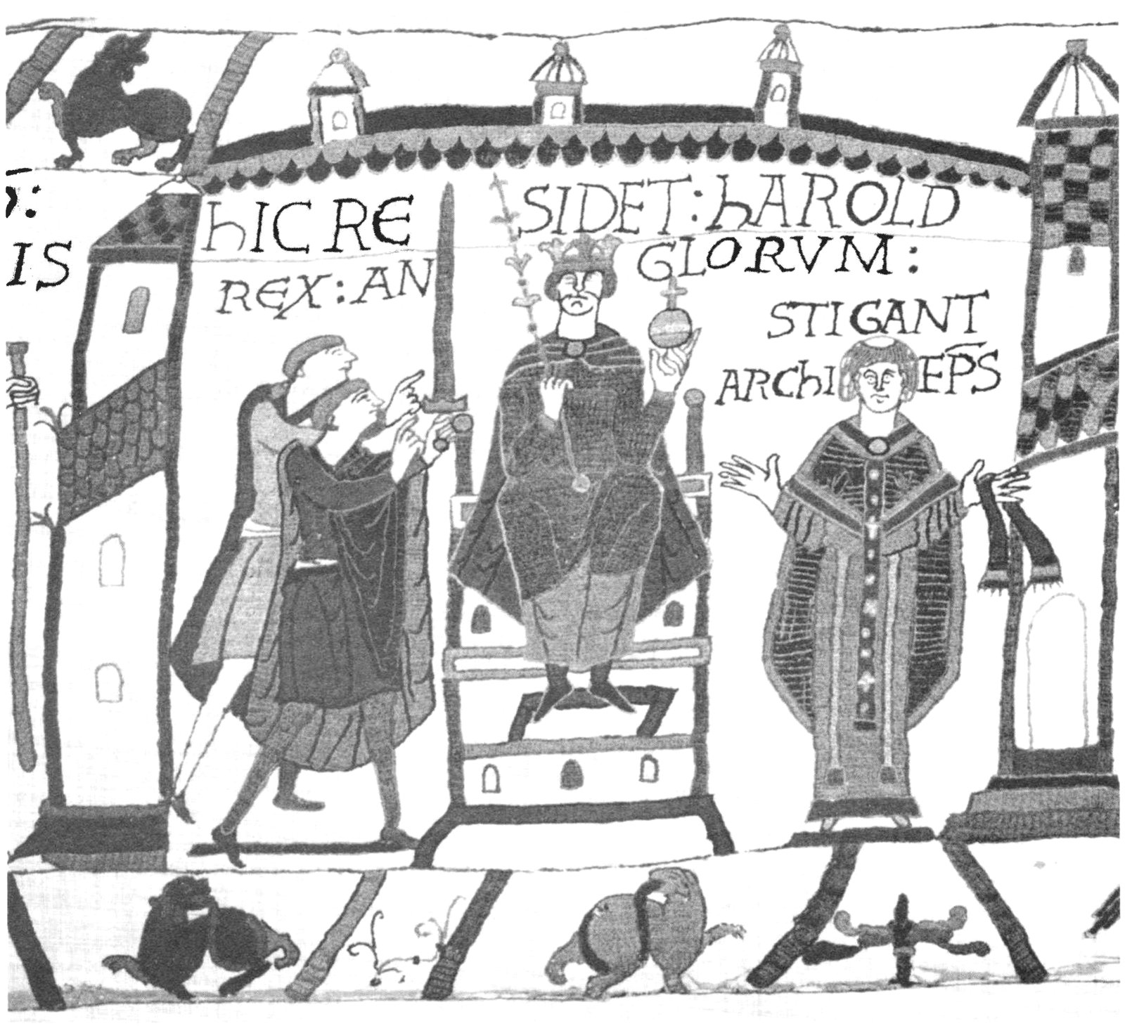
Prior to the Conquest, Earl Harold held the manor of Battersea whose revenue included £6 from the toll (theloneum) of Wandsworth14, while the Archbishop of Canterbury, Lanfranc, held the manor of Mortlake which included a toll (theloneum) of only £1 from Putney15; these are the only four such tolls in Surrey (fig. 3).
In the past commentators have suggested that the toll (£1) at Putney was for ferries16, but the same term being used at Wandsworth for a much larger amount (£6) indicates that there is more involved than just moving people and their goods from one side of the river to the other. With tolls of some £16 relating to ships unloading in Southwark, the conclusion drawn must confirm the impression that at the mouth of the Wandle there was an important river port.
Mills
The value of over £42 attributed to the mills in the manor of Battersea was the highest figure for the whole of Surrey where 66 manors had mills17. This must indicate the importance of them and of the power of the river Wandle. This power was underlined in modern times: ‘After the destruction by fire of the Blackfriars mills, the Wandsworth Mills (Upper and Lower) were the most important in London18.’
The value of the Battersea mills may be compared with the five mills at Kingston with a value of only £119; these mills were presumably on the Hogsmill river.
There is another reference to the mills on the Wandle dated to A.D 1157 in Westminster Abbey muniments, ‘Wandleswrthe cum passagio et molendinis’20, ‘Wandletown with a passage-way (or path)21 and mills’. A passage-way or path in such a location as this might mean a ford across the Wandle; the Domesday reference locates the tolls of Battersea manor at Wandeleford’22.
The Saxon Boundaries
Much has been written about the bounds mentioned in the two Saxon charters bearing the dates A.D. 693 and 95723. The A.D. 693 charter is in a hand of the 11th century, but the bounds, which are written in Old English, are too detailed for them to be 7th century in date. Similarly, the bounds of the A.D. 957 charter are in a 12th century hand but are less detailed24. One conclusion that might be drawn, is that the ‘later’ set of bounds of A.D. 957 is in fact earlier in date.
The relevant parts of the sets of bounds as far as this article is concerned are as follows25:
[p. 8]| A.D. 693 | A.D. 957 |
|---|---|
| Of rysmere into leoddebeorge | fram ryssemere to bælgenham |
| Of leoddebyrge into uckebyrge | |
| Of uccebyrge into bernneardes byriels | fram bælgenham to bernardes byrieles |
| Of byrnærdes byrielse inne thane blacan mor | and swa thanon to tham blachemore |
| Of than blacan more oth middan hlida burnan | fram blachemore to tham coppede thorne |
| fram tham coppede thorne to bænces byri | |
| Of hlida burnan in gibbe felde | |
| Of gibbe felde in tha blaca dic | |
| Andlang blaca dic into beferithi | swa thonon to bæuerithe |
| Of beferithe andlang stræte into fugel rithie | (….*) to fugele rithe |
| Andlang fugel rithie into thære tæmese oth midne streame | thanon north into tæmese be middan stræme |
| *obscure sentence not apparently describing a detailed bound. | |
Two points may be noted: the spelling of Balham is close to that in Domesday, ‘Belgeham’26; the ‘later’ bounds are very much less precise – for example, the two initial points of the ‘earlier’ charter could be seen as following a boundary which skirts the settlement at Balham with its tofts; this could explain why Stane Street/the A24/Balham High Road is not mentioned in either charter. The A.D. 957 (?earlier) charter pointed to the settlement as a very obvious boundary – marker which was later refined.
A study has been made of six Saxon estate boundaries in Buckinghamshire and in all cases they seem to coincide closely with those of the later ecclesiastical parishes, with only minor deviations27.
It is therefore postulated that a similar parallel exists with the Battersea boundary. In the two local charters variations may therefore be seen as minor amendments.
The Southern End of the Bounds
The first name, ‘rysmere’ is usually regarded as a pond somewhere on Clapham Common where the general line of the bounds in not in dispute.
The two mounds at the beginning of the A.D. 693 charter may represent artificial ones used to denote changes in course of the boundary, perhaps even a midden heap or a pile of stones, used as markers around the settlement of Balham. However, ‘beorg’ can also mean a refuge28.
The reference to ‘bernardes byrieles’[p. 9]suggests a number of prehistoric barrows. It has been noted that groups of Bronze Age barrows tend to be linear in Surrey, sometimes contiguous29. Between the parishes of Wandsworth and Streatham, the parish of Battersea extends a long finger southwards (fig. 4). No convincing explanation for this finger of land has yet to be advanced. An appealing solution might be that the finger encompasses a row of barrows, later called ‘bernardes byrieles’. Where lines of barrows occur, they tend to be along a length of high ground, often on a shoulder rather than on a precise ridge so as to show in silhouette from lower ground. This spot along Trinity Road just north of the police station is indeed such a spot.
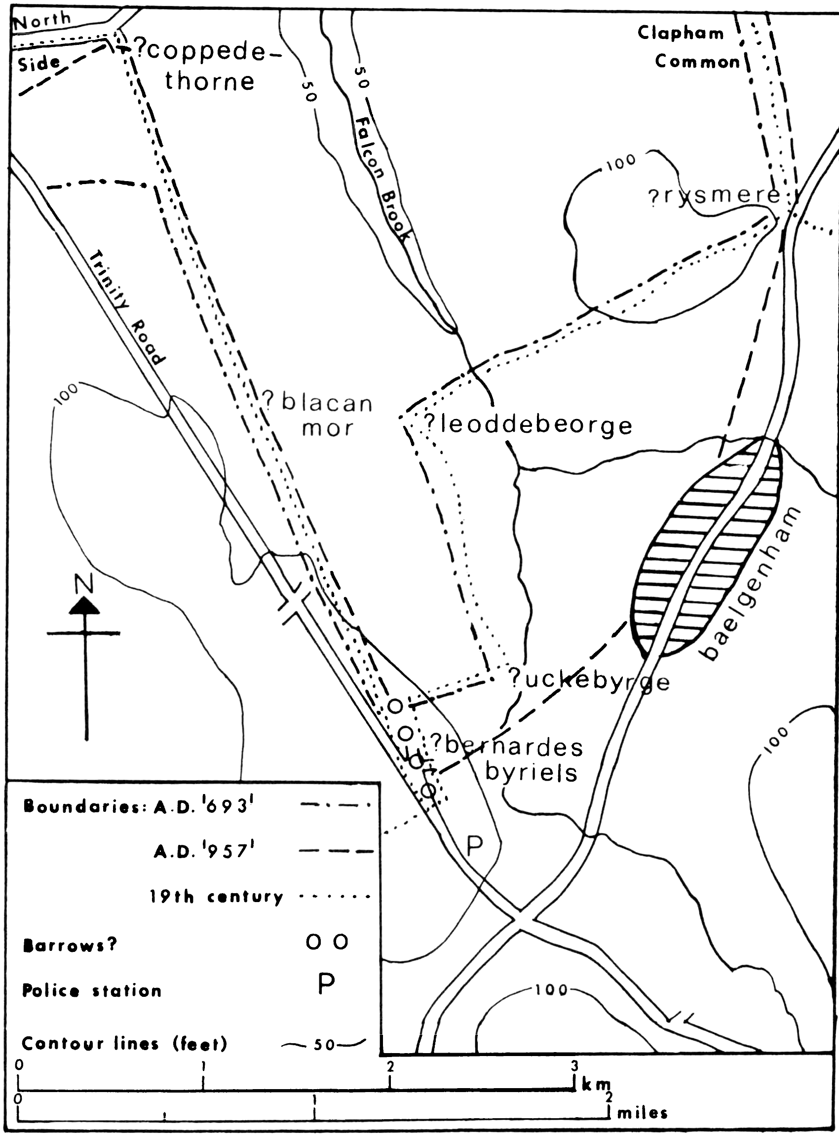
From this area the boundary might be seen as following the modern parish boundary line across Wandsworth Common (prior to recent changes brought about by the [p. 10]railways, etc). The ‘blacan mor’ could then be interpreted as referring to the appearance of the common after an annual burning of the gorse in order to encourage the growth of new shoots which sheep could eat. This practice is still in vogue in parts of Scotland. The ‘coppede thorne’ could then be seen as an area of cut thorns used as a fire-break close to a road or to buildings, perhaps at the north end of the common.
The northern part of the Bounds
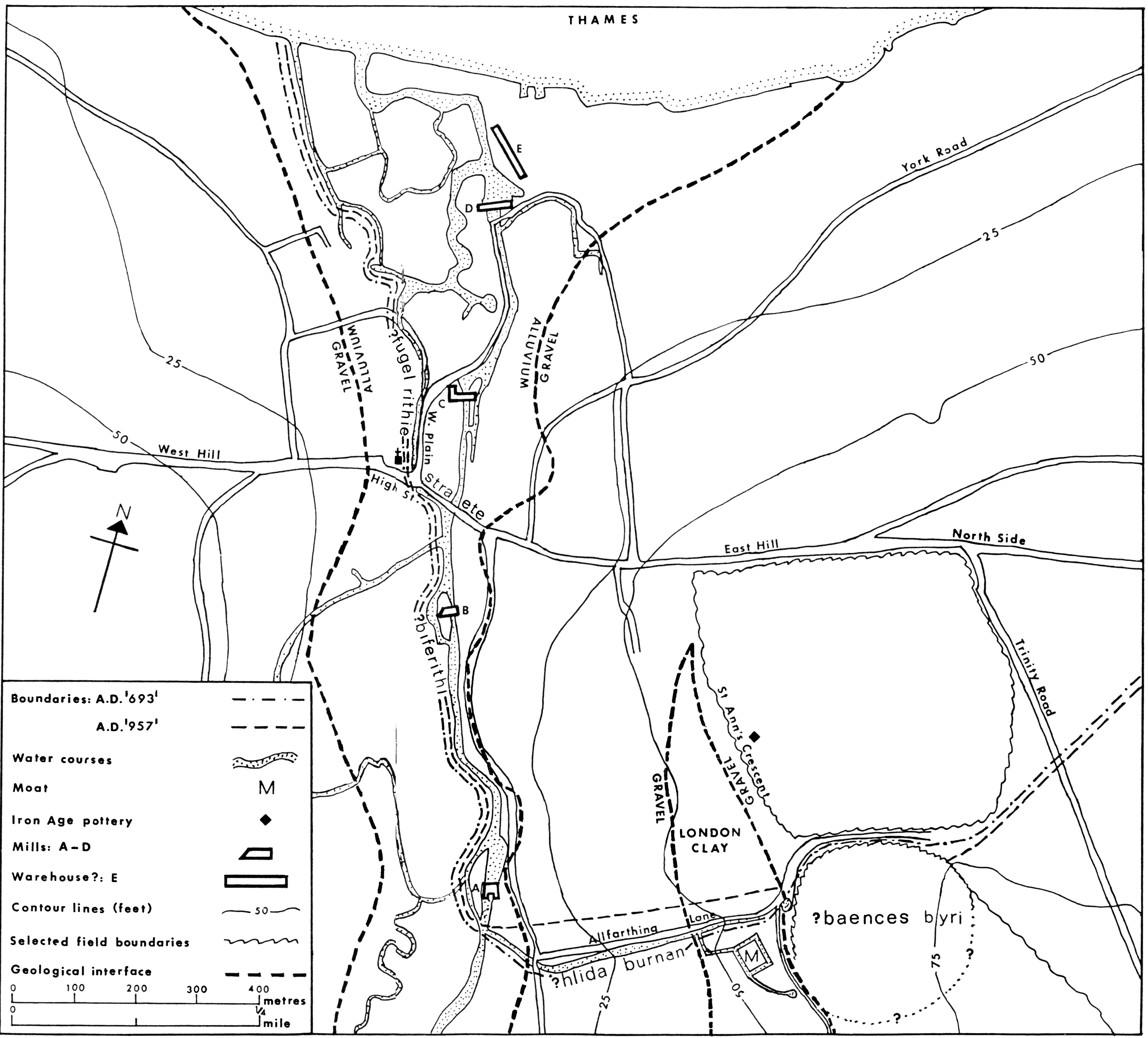
By its name the ‘baences byri’ in the A.D. 957 charter appears to indicate a hillfort, as in South Cadbury, Badbury Rings, etc. The posited site for this feature lies on the south side of the upper leg of Allfarthing Lane where a cur[p. 12]ving track and probable ditch to the west on the Gardner map together with the curves of the Lane shown on 19th century Ordnance Survey maps and Bryant’s map of Surrey (1823)9 make some two-thirds of a circle (fig. 5); the overall size is closely comparable to that of Caesar’s Camp, Wimbledon. The position would place the posited hillfort in the category of Group 5 – ‘cliff edge or plateau edge’, into which Caesar’s camp also falls30. This interpretation is strengthened by the discovery of Early Iron Age pottery found in situ on an excavation in 1971 at 51 St Ann’s Crescent31. Such a site for a hillfort would not conflict with Caesar’s Camp, which is Late Bronze Age/Early Iron Age in date, because each would have its own river valley to dominate; Caesar’s Camp lies on the Beverley.
The translation of ‘hlida’ is slope32, which produces the ‘sloping stream’ or somesuch. This stream might then be seen as the stream which is shown flowing down the lower leg of Allfarthing Lane and into the Wandle on Gardner’s map of 1633; its line would serve as a better boundary-marker than ‘Bensbury’.
The ‘gibbe felde’ might be seen as a meadow alongside the Wandle. The ‘blaca dic’ could be a drainage ditch leading into the Wandle or some other man-made leet; perhaps the Allfarthing stream was canalised.
The ‘beferithi’ has in the past been equated with the Beverley Brook33 but not by all commentators34. The translation is the ‘beavers’ stream’. One of the attributes of the beaver is its propensity for building dams across streams although the Wandle at the height of its powers might well have been too formidable a force for even that animal. It is therefore suggested that the dams of mill ponds across the Wandle river could have earned that name for the secondary leets. Whether the mills were Saxon or earlier is a difficult question.
There is no account of Londinium being captured by the Saxons and place-name evidence relating to ‘Welshmen’ (Walas = sub-Roman Britons) is frequent in the London area. Locally, there was a Walworth (Welshmen’s town) Shot in Battersea just east of the High Street35. There would seem to be no reason why the continuation of population should not also indicate the continuation of postulated Roman mills – no one likes hand-grinding grain. This hypothesis will be more deeply explored in a subsequent article.
To refine the point being made, the boundary may be construed not as running down the mill races of the mills (or their remains), but rather along the leets which contain their mill ponds. The 1633 map clearly shows the Middle and Upper Mills (those upstream from Wandsworth High Street) as straddling the Wandle on its eastern streams.
In the Saxon period a ‘street’ is usually regarded as a Roman road; so the ‘stræte’ is presumably Wandsworth High Street. The ‘fugel rithie’ translates as the ‘bird stream’36. This could be then seen as the side-stream of the Wandle which the Gardner map shows flowing down what is now Wandsworth Plain before it braided into a multiplicity of waterways in the delta. This area later became well known for its osier beds but presumably at one time it may have supported a colony of water-fowl.
General Discussion
The evidence discussed above indicates that not only was there a river port at the mouth of the Wandle, but also the mills were extremely valuable; their value of over £42 may be compared with the highest value in Middlesex of £3 8d at Stepney37 and in Kent of £13 3s 4d for twelve mills at Ewell38.
The coming together in a manor of Wandsworth’s mills and port (and their substantial revenue) with Battersea’s island pasture is an interesting combination. To consider how and why industry, commerce and agriculture could be so linked must largely remain a matter for conjecture. Nevertheless the ‘town’ on the Wandle and the river itself clearly have an economic importance throughout history.
There seem to be two basic lines for further thought: firstly, the bounds of the manor of Battersea were so drawn as to include the eastern bank of the lower Wandle with its mills and its port in order to gain (or retain) the very substantial revenues obtainable from them; alternatively, the ‘town’ of Wandsworth (or its owner) acquired the pasture of Battersea for a reason unknown, but a possibility might be as a ‘country seat’.
Postscript
No attempt has been made to discuss the more general implications of the revised interpretation of this boundary because another article, which will appear in a forthcoming issue of the Historian, will investigate a further perambulation from a third charter which seems to support the general line of the western [p. 13]boundary of Battersea from the point of view of an adjacent estate.
In the meantime readers may care to mull over some earlier views of the subject of the two charters discussed above39.
References
- Domesday Book: Surrey, ed. J.Morris (1979) fol. 6.1. ↑
- T.Hinde, ed. The Domesday Book, England’s Heritage, Then and Now (1985) 265. ↑
- The Victoria History of the County of Surrey. Vol. IV (1912) 8. ↑
- Ibid 12. ↑
- Surrey Taxation Returns (Surrey Rec Soc 18, 1922) 86. ↑
- The Shorter Oxford English Dictionary, ed. C.T.Onions. 3rd edn. (Corr. repr. 1978). ↑
- P.Glanville, London in Maps (1972) 136–7. ↑
- J.G.Taylor, Our Lady of Batersey (1925) 9. ↑
- See note on maps below. ↑
- D.A.Bayliss, Retracing the First Public Railway (1981) 3–6. ↑
- Surrey and Kent Commissioners of Sewers – Court Minutes I (1909) 9. ↑
- J.Bosworth and T.N.Toller, An Anglo-Saxon Dictionary (1892) 1001. ↑
- Morris ed. op cit fol. 5.28. ↑
- Ibid fol. 6.1. ↑
- Ibid fol. 2.3. ↑
- S.MacRobert, Putney: a brief history (1977) 11. ↑
- C.W.Lloyd, ‘Surrey’ in H.C.Darby and E.M.J. Campbell, ed. The Domesday Geography of South-East England (1962) 400. ↑
- A.E.G. The Mills and Mealemen of Wandsworth (1911) [The Boro’ News Handbooks no. 1]. ↑
- Morris, ed. op cit fol. 1.8. ↑
- Taylor, ed. op cit 7, n.42 ↑
- R.E.Latham, Revised Medieval Latin Word-List (1965) 335. ↑
- Morris, ed. op cit fol. 6.1. ↑
- In particular K.A.Bailey, ‘Battersea in the Dark Ages’ Wandsworth Hist 3 (1971) 1–8. ↑
- C.R.Hart, The Early Charters of Eastern England (1966) 141. ↑
- W.de G. Birch, Cartularium Saxonicum 1 (1885) 82; 3 (1893) 994. ↑
- Morris, ed. op cit fol. 26. ↑
- M.Reed ‘Buckinghamshire Anglo-Saxon Charter Boundaries’ in M.Gelling, The Early Charters of the Thames Valley (1979) 168. ↑
- Bosworth and Toller, op cit 85. ↑
- S.Needham, ‘The Bronze Age’ in J.Bird and D.G. Bird, ed. The Archaeology of Surrey to 1540 (1987) 106 and fig. 5.5. ↑
- J.Forde-Johnston, Hillforts of the Iron Age in England and Wales (1976) 83. ↑
- R.J.Hurst, ‘Some Iron Age Finds in Wandsworth’, Wandsworth Hist 2 (1971) 6–7. ↑
- E.Ekwall, English River Names (1928) 432. ↑
- K.Bailey, ‘Some Place-name Evidence for Anglo-Saxon Settlement in the Wandsworth Area’ Wandsworth Hist 23 (1979) 1–4. ↑
- Taylor, op cit 304, n.8. ↑
- Ibid, 416 and map. ↑
- Bosworth and Toller, op cit 343. ↑
- E.M.J.Campbell, ‘Middlesex’ in Darby and Campbell, ed. op cit 129. ↑
- E.M.J.Campbell, ‘Kent’ in Darby and Campbell, ed. op cit 541. ↑
- Keith Bailey ‘Battersea in the Dark Ages’ Wandsworth Hist 3 (1971) 1–8.
Keith Bailey ‘Some observations on the boundary between the parishes of Wandsworth and Wimbledon’ Wandsworth Hist 35 (1982) 1–4.
Keith Bailey ‘Balham and Tooting in the Dark Ages’ Wandsworth Hist 40 (1984) 1–7.
D. Haselgrove ‘Saxon Putney: a view from across the river’ Wandsworth Hist 40 (1984) 22–23.
Graham Gower ‘Some observations on the Battersea Boundary through West Streatham’ Wandsworth Hist 58 (1989) 9–13 (transcribed here). ↑
Maps
- John Norden, Westminster [in 1593] published in his Speculum Britanniae Pars Middlesex, 1593. Reproduced in P.Glanville London in Maps (1972) 79, pl. 4.
- Carrington Bowles’ Reduced New Pocket Plan of the Cities of London and Westminster with the Borough of Southwark…1780. Glanville op cit 136–7, pl. 33.
- Thomas Milne, Plan of the cities of London and Westminster, 1800. Glanville, op cit 148–9, pl. 39.
- John Corris, A Plan of Wandsworth-Parish in the County of Surrey, 1787. British Library, Althorp Papers P.13 pt 1.
- John Rocque, An Exact Survey of the City’s of London, and Westminster ye Borough of Southwark and the County near Ten Miles around, 1741.
- Peter Gardner. An exact plott and discription of the Mannor of Allfarthinge…1633, copied 1640. Surrey Record Office, SRO 25/2.
- Andrew Bryant, County of Surrey, 1823. Glanville op cit 163, pl. 46.
- Ordnance Survey Map (2nd edition). Surveyed 1861–1871, published 1876. Reproduced in The Village London Atlas: the Growth of Victorian London 1822–1903 (1986) 133, at a scale of 2″ to the mile.
- Ordnance Survey Map (1822). Reproduced in The Old Series Ordnance Survey Maps of England and Wales: Vol IV – Central England. Lympne Castle: Harry Margary, 1986, at a scale of 1″ to the mile.