Google aerial view, 2025
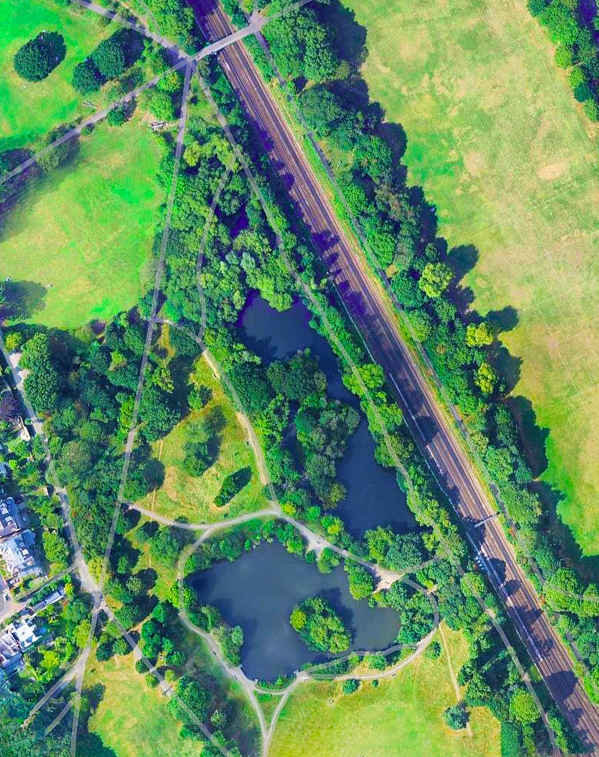
— Lake
Google: The Lake, Wandsworth Common
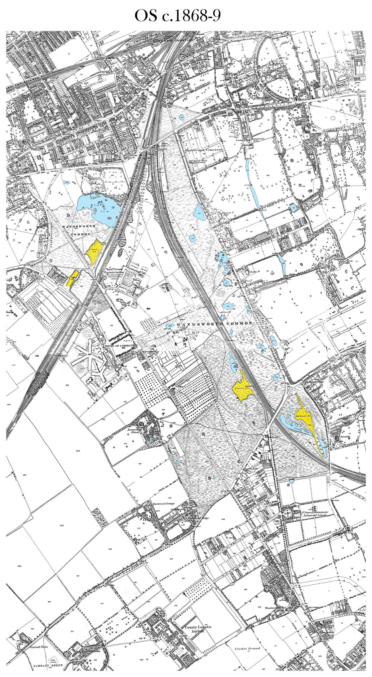
Spot the pond . . .
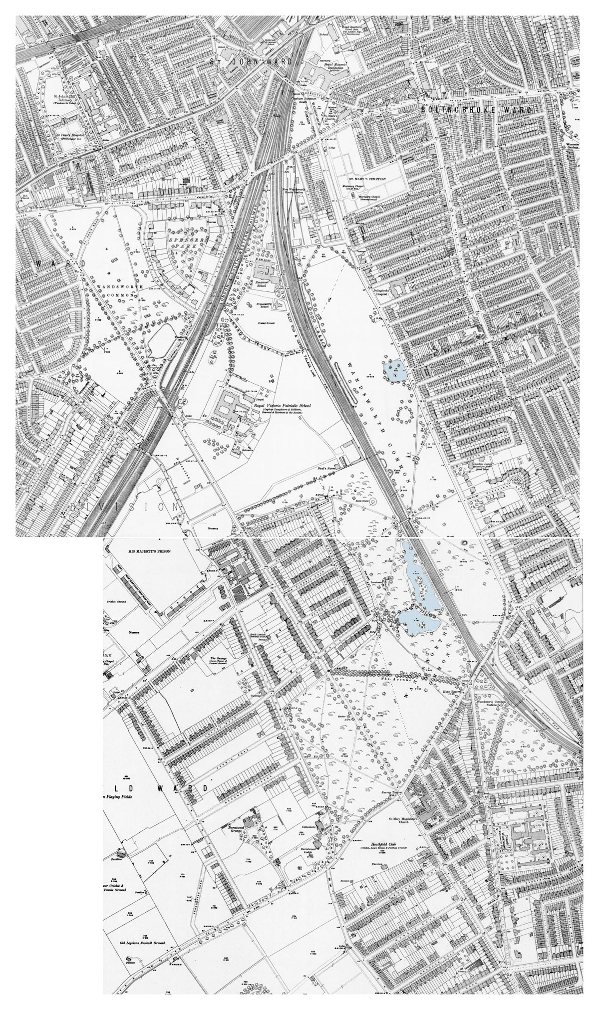
No lake, though some large gravel pits are marked.
The Black Sea, the 3-Island Pond, and some other ponds were nearby.
Presumably any of the gravel pits - and there many - could have ended up as our Lake. Why this one?

Lots of water shown all over the Common, and gravel pits.
The largest stretches are the Black Sea in the north, and flooded gravel pits near what would soon be Wandsworth Common station - now built over, of course.
Notice the 3-Island Pond, and another pond just to the north, opposite Bolingbroke House at the top of what will be Wakehurst Road - where Edward Thomas lived until the age of 10 [?]. He writes about this as [name?].
Gravel was used in great amounts not only for roads, paths and general building, but also on railway tracks.
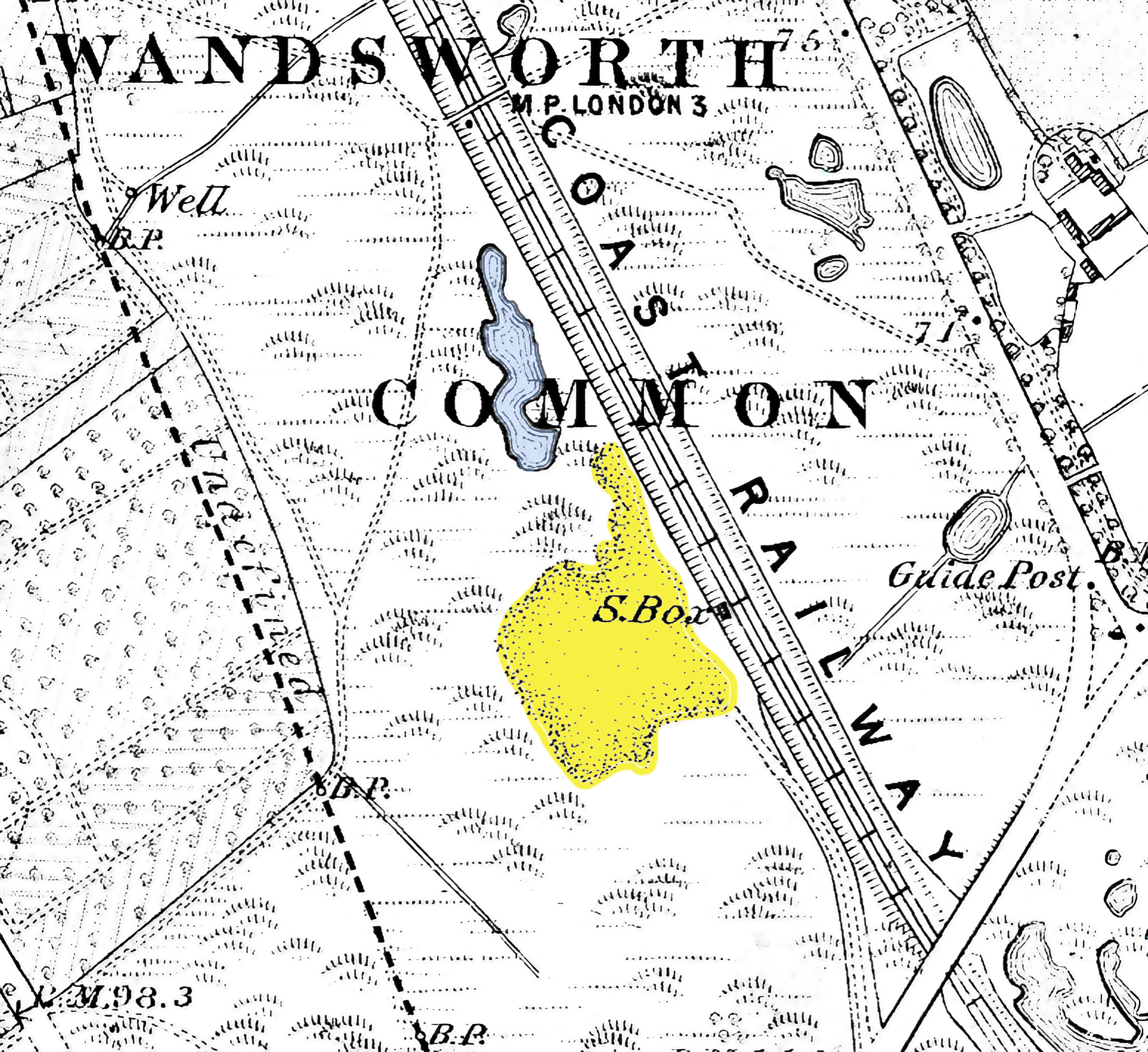
Notice the arrival of a pond, which I've tinted blue, near the Cats Back Bridge. As yet, it's long and thin, and altogether much smaller than today's northern lobe. Presumably it had been a small gravel quarry.
Nearby, a fairly large gravel quarry, tinted yellow. The steep slop/ edges of this quarry can still be seen today, between the lake and the path to the Hope pub. Clearly the southern lobe was created out of the (lower) part of this quarry closest to the railway line.
How much digging out did they have to do?
Unlike the Black Sea, it was never particularly deep (how deep?). This was probably because, unlike the Black Sea, it was never intended to be a reservoir. (By the 1870s, there were water pipes servicing nearby houses.)
Also, at a certain point you would meet the clay beneath the gravel, and where would you put the surplus clay?
The gravel was easy to get rid of - indeed, to sell.
But the clay? Was surplus clay used to fill holes elsewhere on the Common? (I suspect most of the holes we see o the [1860s] OS map had disappeared by the mid-1870s, which fits the theory.)
The proximity to the railway is also a puzzle. Did water not cascade over into the railway line?
NB There was a sluice gate - an outlet - on the corner of the lake nearest the Hope.
Why is the lake here?
It's worth thinking about the fate of raindrops falling on the Common...
They fall from the clouds onto the Common
And then what?
Some penetrates deep into the ground, but a lot flows way
In which directions?
The Common is overall a fairly smooth tabletop or plateau.
But it's a slightly wonky table.
But it falls across its width...
From a ridge down to Bolingbroke Road, and then to the (now underground) Falcon Brook
And also across its length...
It's higher in the south than the north, above the Thames
that descends from a ridge.
Where is this ridge?
Trinity Road?
No - it runs more or less exactly along Lyford Road and Heathfield Road. These are sections of our Ridgeway.
On the other side of these roads, there is a more or less narrow plateau, then a fairly steep decline down to Garratt Lane and Wandle Valley.
So all water falling on the far side of the ridge flows south-west down to the Wandle.
And all that falls on the Common, north-east and north downhill to the Falcon Brook.
(Now under the road in front of Hendrick Road - or, more likely, behind the Henroick houses.
Notice, by the way, the slight curve in Hendrick Road - quite unusual in an otherwise more rigidly straight, grid-like local streets Does this reflect the original course of the Falcon Brook?
Ditto between Montholme and Blenkarne/Gorst Roads...
Then Northcote Road
[But notice the slightly different alignments - between Montholme and Blenkarne/Gorst Roads, but down the middle of Northcote Road...]
Curiously, the lake is still not recorded on the 1872 Stanford map. Presumably wasn't deemed worthwhile to update the 1860s' printers' plates.
[/maps/stanford_1872/stanford-1872-wc-2048px-min.jpg]


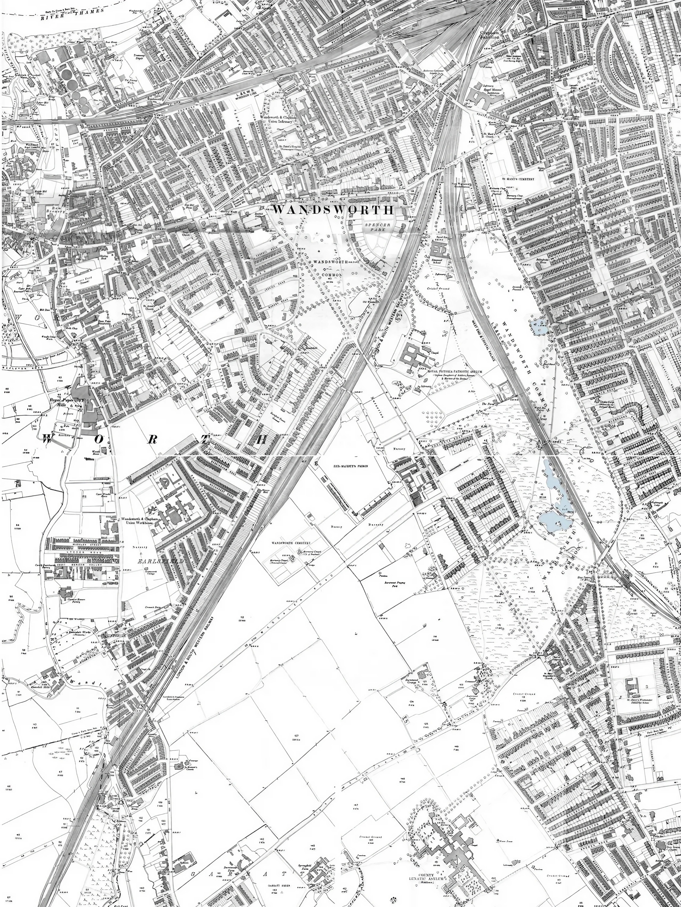

Showing the island in the northern lobe is now distinct.

Spot the pond . . .
No lake, though some large gravel pits are marked.
The Black Sea, the Three-Island Pond, and some other ponds were nearby.
Presumably any of the gravel pits—and there are many—could have ended up as our Lake. Why this one?
Lots of water is shown all over the Common, and gravel pits.
The largest stretches are the Black Sea in the north, and flooded gravel pits near what would soon be Wandsworth Common station—now built over, of course.
Notice the Three-Island Pond, and another pond just to the north, opposite Bolingbroke House at the top of what will be Wakehurst Road—where Edward Thomas lived until the age of 10 [?]. He writes about this as [name?].
Gravel was used in great amounts not only for roads, paths and general building, but also on railway tracks.
Notice the arrival of a pond, which I've tinted blue, near the Cats Back Bridge. It's much smaller than today's lake. As yet, it's narrow, not lobed, has no islands. Presumably it had been a small gravel quarry.
Nearby, a fairly large gravel quarry, tinted yellow. The steep slope/ edges of this quarry can still be seen today, between the lake and the path to the Hope pub. Clearly the southern lobe was created out of the (lower) part of this quarry closest to the railway line.
A track on which the gravel must have been hauled starts opposite the Hope. Was this the part of St James's Road projecting beyond the Hope to Bolingbroke Grove - where did it meet? Opposite what will be Blenkarne Road? Interrupted by the coming of the railway line to Crystal Palace i te late 1950s, it was later abandoned altogether.

How much digging out did they have to do?
Presumably quite a bit of the work had already been done by the gravel diggers.
Unlike the Black Sea, it was never particularly deep (how deep?). This was probably because, unlike the Black Sea, it was never intended to be a reservoir. (By the 1870s, mains pipes were providing water to nearby houses.) I have read that the northern lobe is much shallower than the larger, southern lobe. And this has created a problem for fish. In hot summers the shallower pond is mre likely to overheat and fish die. This partly explains the barrier beneath the bridge between the two lobes - fish having been largely removed to the larger pool.Also, at a certain point you would meet the clay beneath the gravel, and where would you put the surplus clay?
I assume, but don't know, that some of this material was used to fill the innumerable small pits and ponds all over the Common (particularly, it would seem, on the Battersea side.
Unlike in Battersea Park, the digging of the lake doesn't seem to have been associated with landscaping - gentle hills and islands created for visual delight above the Thames flood plain. Here it was probably more to do with levelling the ground - on large areas (after trees and furze had been grubbed up) to create pitches - cricket in summer, football in winter, and (on smaller areas) where tennis could be played.
Did the lake need to be "puddled" - lined with a layer of clay to retain water, like a pond liner? Presumably not, if they had reached dense natural clay.
The gravel was easy to get rid of—indeed, to sell.
But the clay? Was surplus clay used to fill holes elsewhere on the Common? (I suspect most of the holes we see o the [1860s] OS map had disappeared by the mid-1870s, which fits the theory.)
"Puddling a pond with clay involves creating a watertight layer by compacting damp clay until it reaches a plasticine-like consistency, which is achieved by treading on it, driving a machine over it, or using a mechanical roller. This traditional method requires a layer of clay 6-8 inches or more thick that must be kept moist to prevent cracking, and is suitable for both new ponds and maintaining existing ones, as seen in canal systems. "We're standing here on the edge of a great cliff that descends to the plain below. The edge swings round to our right, then tapers and gradually disappears.
In the distance, we see Wandsworth Common's Great Lakes.
Today, there's only one other stretch of water on the Common, and that's the Three-Island Pond near Bolingbroke Grove on the other side of the railway line. It's much smaller and also much older than this lake — it may have been dug towards the end of the C18 when the Five Houses were built.
It's altogether more formal, more regular. Almost exactly a circle, with three neat islands. And its edge has been built up with concrete.
You can see it on this map . . . .
But nothing of the Great Lake.
Can you see anything in this landscape that might suggest the Lake's origin?
To pond or not to pond?
Throughout March and April 1873 a battle raged in local newspapers over the digging of a new stretch of ornamental water — the once-picturesque "Black Sea" having recently been filled in to make way for the building of Spencer Park. This was one of the first projects undertaken by the new democratically elected Conservators of the Common, who had taken over control in 1871.
This is what we now call "the lake" (though a young me in the 1950s always knew it only as "The Pond"). Perhaps surprisingly to us today, most of the letters printed at the time are very much against creating a pond, even if it were to be financed entirely by voluntary subscription, with no cost to the rate-payers of Battersea and Wandsworth.
Its critics mocked those who did not live close to the Common, saying "Oh, we like to see a piece of water when the sun shines on it". They ridiculed the "Lilliputian" islands. The critics listed numerous risks, from an extra burden on rate-payers and Common-keepers for maintenance and supervision, to pollution and lethal disease (not such an unreasonable caution given how recently cholera had swept through local communities).
And then there was its inevitable use for swimming and horseplay, when "grown lads . . . would be seen undressed or partially attired, to the disgust and annoyance of . . . every lady who passed by").
[A few examples of letters/articles?]
[Outline how it was privately funded.]
[But accept th concerns about cholera, dysentery etc were well-founded.

But the Conservators had their way and the lake was dug (and enlarged later, to create the large island). I think most people would say that the lake has been a wonderful acquisition, for which generations since have been grateful.


He also writes about "the roundish Box Pond that lay half-way between the top of our street and the railway", filled in at the end of the nineteenth century:

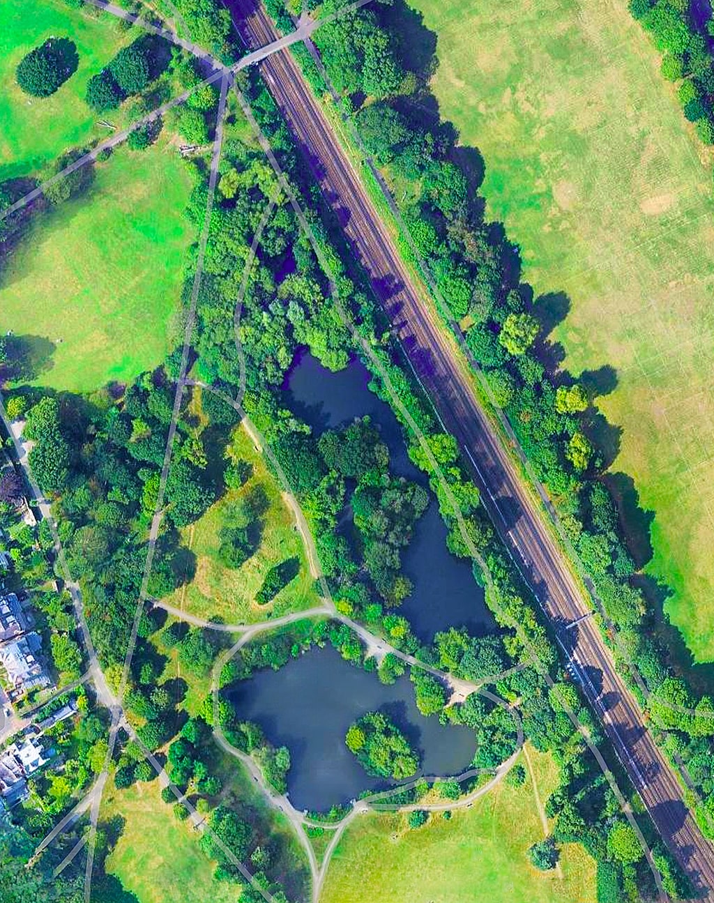

OpenStreetMap: The Lake, Wandsworth Common
— Link
— Link
— Link
Back to the top of this page . . .