15th May 2021
Beating the Bounds
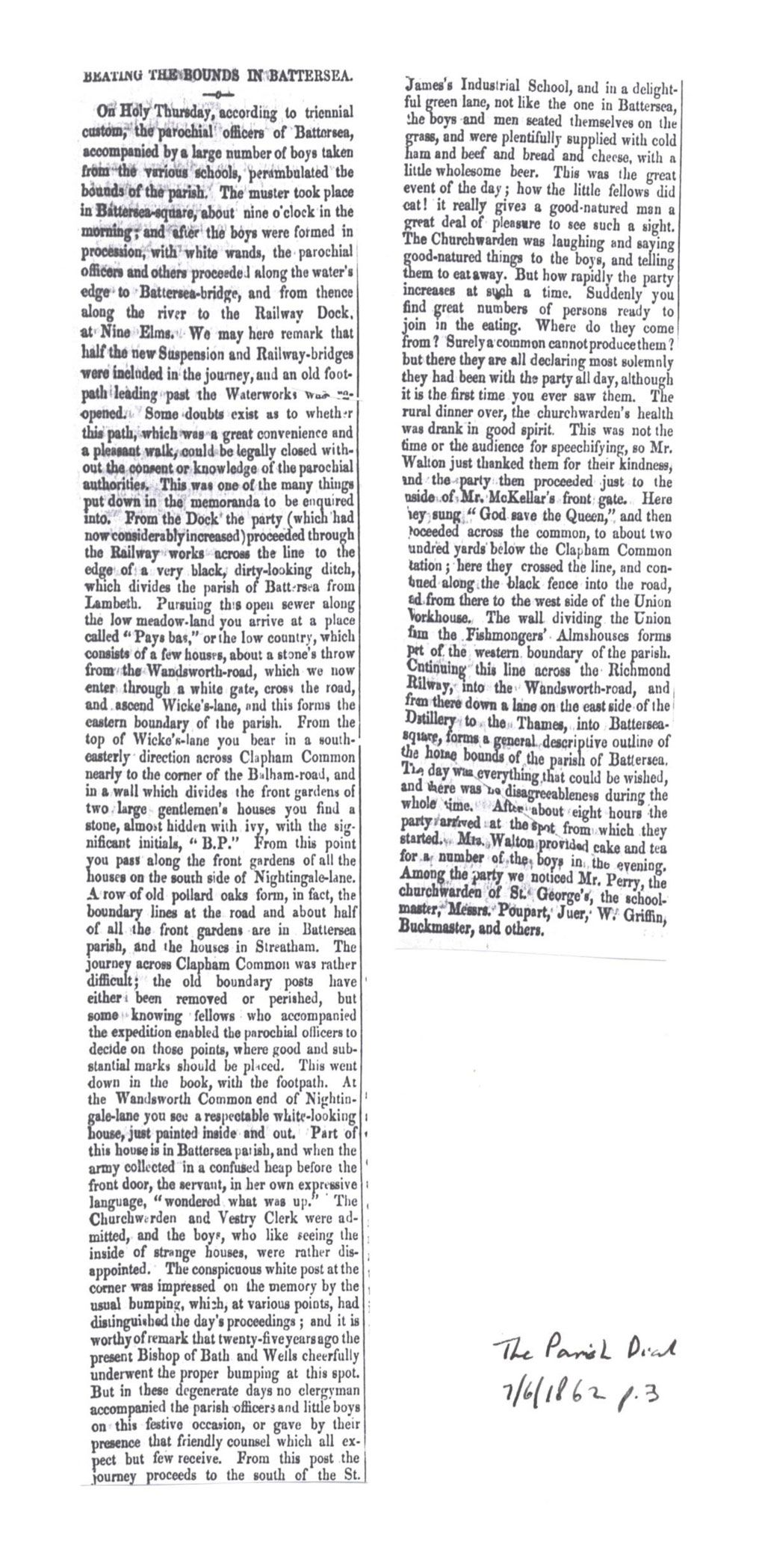
John Buckmaster et al's perambulation of Battersea Parish, 17 March 1862.

On Holy Thursday, according to triennial custom, the parochial officers of Battersea, accompanied by a large number of boys taken from the various schools, perambulated the bounds of the parish.
The muster took place in Battersea-square, about nine o'clock in the morning; and after the boys were formed in procession, with white wands, the parochial officers and others proceeded along the water's edge to Battersea-bridge, and from thence along the river to the Railway Dock, at Nine Elms..."

"Beating the Bounds in Battersea", The Parish Dial, 7 June 1862
The perambulation shown on the contemporary Stanford's 6-inch Library map of 1862. It starts and ends at Battersea Square, near St Mary's, the parish church.
(Click on image to enlarge)
I am very grateful to Sean Creighton and Roger Logan for sending me a batch of cuttings featuring John Buckmaster, among which was this gem — a "perambulation" around Battersea in 1862. I have highlighted the route on a contemporary map (Stanford's Library Map of London 1862) — the purple parish boundary line is on the original map. Notice the walk proceeds clockwise, in customary fashion, beginning and ending near the parish church of St Mary's.
(Click on image to enlarge)

Boys were co-opted to accompany the parish officials and others, and equipped with "white wands" — usually willow or birch stripped of their bark. Since paths and fences had often become overgrown or encroached upon between successive "Beatings", boys were useful to climb over or through any obstruction.
(Why are girls not mentioned? Is it because there were none there that day, or because they simply weren't recorded? In some perambulations elsewhere girls and women are known to have worn and carried garlands of flowers and foliage.)
Before detailed maps and official boundary markers, this was the way people down the generations knew exactly where the parish boundaries and footpaths were situated — the boys beating the boundary features with their wands, or in many cases being themselves beaten or bumped (and sometimes held upside down and shaken vigorously) at every significant point.
Such were contemporary ideas of pedagogy, which seem on the whole to have been pretty successful — as you will see when the beaters came to deciding the route of the boundary across Clapham Common.
"Beating the Bounds in Battersea", The Parish Dial, 7 June 1862
Stanford's 6-inch Library map of 1862. The perambulation starts and ends at Battersea Square, near St Mary's, the parish church.
(Click on image to enlarge)
BEATING THE BOUNDS IN BATTERSEA.
On Holy Thursday, according to triennial custom, the parochial officers of Battersea, accompanied by a large number of boys taken from the various schools, perambulated the bounds of the parish.
The muster took place in Battersea-square [1], about nine o'clock in the morning; and after the boys were formed in procession, with white wands, the parochial officers and others proceeded along the water's edge to Battersea-bridge [2], and from thence along the river to the Railway Dock, at Nine Elms [5].
We may here remark that half the new Suspension and Railway-bridges were included in the journey [3], and an old foot-path leading past the Waterworks was re-opened [4]. Some doubt exists as to whether this path, which was a great convenience and a pleasant walk, could be legally closed without the consent or knowledge of the parochial authorities. This was one of the many things put down in the memoranda to be enquired into.
From the Dock the party (which had now considerably increased) proceeded through the Railway works [5] across the line to the edge of a very black, dirty-looking ditch, which divides the parish of Battersea from Lambeth [6].
Pursuing this open sewer along the low meadow-land you arrive at a place called "Pays bas," or the low country, which consists of a few houses, about a stone's throw from the Wandsworth-road, which we now enter through a white gate, cross the road, and ascend Wicke's-lane [7], and this forms the eastern boundary of the parish.
[Jon Newman mentions this are in Heathwall — follow up.]
From the top of Wicke's-lane you bear in a south-easterly direction across Clapham Common [8] nearly to the corner of the Balham-road, and in a wall which divides the front gardens of two large gentlemen's homes you find a stone, almost hidden with ivy, with the significant initials, "B.P." [where? whose houses?]
From this point you pass along the front gardens of all the houses on the south side of Nightingale-lane [9]. A row of old pollard oaks forms, in fact, the boundary lines at the road and about half of all the front gardens are in Battersea parish, and the houses in Streatham.
The journey across Clapham Common was rather difficult; the old boundary posts have either been removed or perished, but some knowing fellows who accompanied the expedition enabled the parochial officers to decide on those points, where good and substantial marks should be placed. This went down in the book, with the footpath.
At the Wandsworth Common end of Nightingale-lane you see a respectable white-looking house, just painted inside and out [10]. Part of this house is in Battersea parish, and when the army collected in a confused heap before the front door, the servant, in her own expressive language, "wondered what was up."
The Churchwarden and Vestry Clerk were admitted, and the boys, who like seeing the inside of strange houses, were rather disappointed.
The conspicuous white post at the corner was impressed on the memory by the usual bumping, which, at various points, had distinguished the day's proceedings; and it is worthy of remark that twenty-five years ago the present Bishop of Bath and Wells cheerfully underwent the proper bumping at this spot. But in these degenerate days no clergyman accompanied the parish officers and little boys on this festive occasion, or gave by their presence that friendly counsel which all expect but few receive.
From this post the journey proceeds to the south of the St. James's Industrial School [11], and in a delightful green lane, not like the one in Battersea, the boys and men seated themselves on the grass, and were plentifully supplied with cold ham and beef and bread and cheese, with a little wholesome beer.
This was the great event of the day; how the little fellows did eat! it really gives a good-natured man a great deal of pleasure to see such a sight. The Churchwarden was laughing and saying good-natured things to the boys, and telling them to eat away.
But how rapidly the party increases at awls??? a time. Suddenly you find great numbers of persons ready to join in the eating. Where do they come from? Surely a common cannot produce them? but there they are all declaring most solemnly they had been with the party all day, although it is the first time you ever saw them.
The rural dinner over, the churchwarden's health was drank in good spirit. This was not the time or the audience for speechifying, so Mr. Walton just thanked them for their kindness, and the party then proceeded just to the side of Mr. McKellar's front gate [12]
Here they sung "God save the Queen," and then proceeded across the common [13], to about two hundred yards below the Clapham Common station [14]; here they crossed the line, and continued along the black fence into the road, and from there to the west side of the Union workhouse [15]. The wall dividing the Union from the Fishmongers Almshouses forms part of the western boundary of the parish.
Continuing this line across the Richmond Railway [16], into the Wandsworth-road, and from there down a lane on the east side of the Distillery [17] to the Thames, into Battersea-square [1], forms a general descriptive outline of the home bounds of the parish of Battersea.
The day was everything that could be wished, and there was no disagreeableness during the whole time.
After about eight hours the party arrived at the spot from which they started. Mrs. Walton provided cake and tea for a number of the boys in the evening. Among the party we noticed Mr. Perry, the churchwarden of St. George's, the school-master, Messrs. Poupart, Juer, W. Griffin, Buckmaster, and others.
Notes and commentary
BEATING THE BOUNDS IN BATTERSEA.
On Holy Thursday, according to triennial custom, the parochial officers of Battersea, accompanied by a large number of boys taken from the various schools, perambulated the bounds of the parish.
The muster took place in Battersea-square [1], about nine o'clock in the morning; and after the boys were formed in procession, with white wands, the parochial officers and others proceeded along the water's edge to Battersea-bridge [2], and from thence along the river to the Railway Dock, at Nine Elms [5].
"Holy Thursday" in this case is not the Thursday before Good Friday (i.e. Maundy Thursday) but "Ascension Day" — the 40th day of Easter (39 days after Easter Sunday). It celebrates Jesus's ascension to heaven after he was resurrected on Easter Day. In 1862 this was May 29.
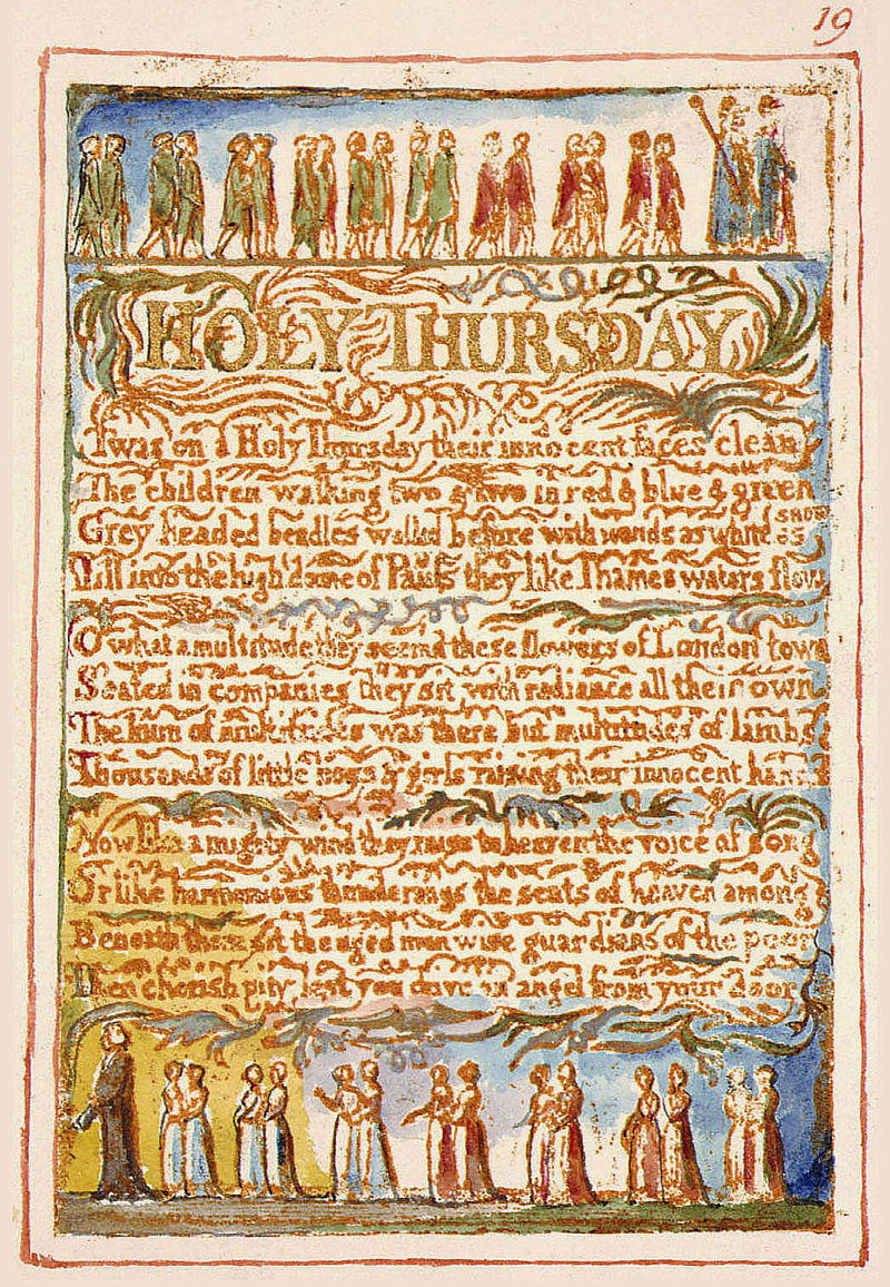
See e.g. William Blake, "Holy Thursday", from Songs of Innocence:
(Click on image to enlarge)
Twas on a Holy Thursday their innocent faces clean
The children walking two & two in red & blue & green
Grey headed beadles walkd before, with wands as white as snow
Till into the high dome of Pauls they like Thames waters flow
O what a multitude they seemd these flowers of London town
Seated in companies they sit with radiance all their own
The hum of multitudes was there but multitudes of lambs
Thousands of little boys & girls raising their innocent hands
Now like a mighty wind they raise to heaven the voice of song
Or like harmonious thunderings the seats of heaven among
Beneath them sit the aged men wise guardians of the poor
Then cherish pity, lest you drive an angel from your door[10]
https://en.wikipedia.org/wiki/Holy_Thursday_(Songs_of_Innocence)
"Triennial custom" — three years may have been true in Battersea, but seven or ten years were perhaps more usual elsewhere.
"The parochial officers" included the churchwarden of St Mary's [name?]. John Buckmaster did not become churchwarden here until [1867?]. At this time, was he an Overseer?
There are many accounts of perambulations online. One of the most informative is Beating the Cholesbury Bounds:
"The custom of 'beating the bounds' has existed in Britain for well over 2000 years. Precise origins are unclear although it can be found as part of ritual celebration within many different cultures across Europe and beyond. In simple terms it involves people in the locality perambulating their farm, manorial, church or civil boundaries pausing as they pass certain trees, walls and hedges that denote the extent of the boundary to exclaim, pray and ritually 'beat' particular landmarks with sticks.
"These sticks would originally have been of birch or willow, both being of significance to pre-Christian tribes. Birch has connection with besoms, which have ancient connections with pagan festivals however the willow possessing a close association with water appears to have predominated in medieval times. The sticks were known as rods or wands. The bark was removed exposing the white wood beneath. The English folk-song "Stripping The Willow" is a relatively modern record of these practices.
"Such processions would typically occur every seven or ten years. Apart from any religious significance in a time when literacy or map-reading were not widespread skills these inspections served to ensure boundaries remained intact, were known by local people and had not been sequestrated by neighbouring landowners.
"Other activities associated with these processional, religious or secular rituals have also survived. Most frequently, at certain points on the boundary, young boys were held upside down and had their heads bumped on a marker stone.
"In past times adolescent boys might also be 'switched' (i.e. hit with the willow wands), thrown over hedges, into brambles or ponds or required to climb up chimneys or over roofs. These actions may have originally had a darker antecedents but in more recent times ensured the imprinting of the exact location of a boundary by successive generations of that community.
[See also the reference to "bumping" the Bishop of Bath and Wells, below.]
We may here remark that half the new Suspension and Railway-bridges were included in the journey [3], and an old foot-path leading past the Waterworks was re-opened [4]. Some doubt exists as to whether this path, which was a great convenience and a pleasant walk, could be legally closed without the consent or knowledge of the parochial authorities. This was one of the many things put down in the memoranda to be enquired into.
[Add dates of e.g. Chelsea Bridge, Grosvenor Bridge etc?]
From the Dock the party (which had now considerably increased) proceeded through the Railway works [5] across the line to the edge of a very black, dirty-looking ditch, which divides the parish of Battersea from Lambeth [6].
["Proceeded... across the line" — interesting! A little later, Emanuel schoolboys crossed directly from the school to the east side of the Common to e.g. play football. Obviously there was no electrification at this time, and presumably fewer trains ? — and of course noisy steamy smoky trains gave plenty of advance warning.]

This "very black, dirty-looking ditch, which divides the parish of Battersea from Lambeth" is the curious, almost semi-circular Heathwall Sluice between Nine Elms and Battersea Creek that in effect made an island of Battersea [as incorporated in a number of [fanciful?] speculative etymologies [Patrick's Eye " i.e. island].
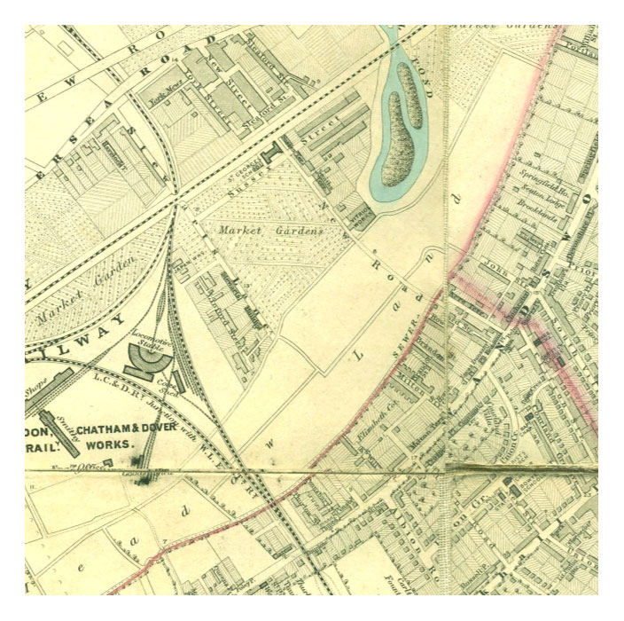
The Stanford map marks it as a sewer. However, at this time the word "sewer" still largely meant a seasonal open waterway draining away heavy rainfall, rather than the underground conduit for the disposal of human waste. See Jon Newman's fine book The Heathwall: Battersea's buried river, in which this helpful map of the layout c.1840 can be found.
Pursuing this open sewer along the low meadow-land you arrive at a place called "Pays bas," or the low country, which consists of a few houses, about a stone's throw from the Wandsworth-road, which we now enter through a white gate, cross the road, and ascend Wicke's-lane [7], and this forms the eastern boundary of the parish.
From Jon Newman, Heathwall:
[Turn ] left onto Ashley Crescent to its junction with Queesntown Road where two cast iron boundary posts stand in the middle of the path.
..After the tidy survival of the Shaftesbury, this area feels more of a rag-bag of Victorian terraces, bits of post-war public housing and bobs of more recent private developments. On the right the blocks of the Ashley Cour estate (1960s) running up the slope to Lavender Hill have replaced the older line of Beaufoy Street (1880s).
Previously, this had been the entrance lane to Beaufoy's chemical works on the north side of the Heathwall.
The Beaufoys were successful Huguenot vinegar makers on the Thames at Lambeth and then on South Lambeth Road. This works was an expansion into chemical vinegar production using acetic acid. Beaufoys called their 17-acre site Pays Bas, the French for 'low country', apt enough but phonetically beyond the locals who pronounced it 'Pay Bar' (a misnomer that made it into print on Stanford's 1862 map).
Pays Bas is also the French name for Holland, which feels equally fitting, seamed as this area was with "curious marshy ditches in which horse leeches were found". The artist Turner, living in Chelsea riverside in the late 1840s, used to refer to the prospect south from his window over Battersea as "my Dutch view".
[Jon Newman, Heathwall, p.20]
Much more on Beaufoys — "Beaufoys of Lambeth", Greater London Industrial Archaeology Society
[Source: Link]
[Source: pdf]
Diana Gunasena, "The Beaufoys of Battersea", Wandsworth Historian, 61, 64, 68.
Saved as:[Source: Link]
D_Gunasena_BEAUFOYS_AT_BATTERSEA_WHS_61_64_68.pdf
"Pays bas" — a Huguenot survival?
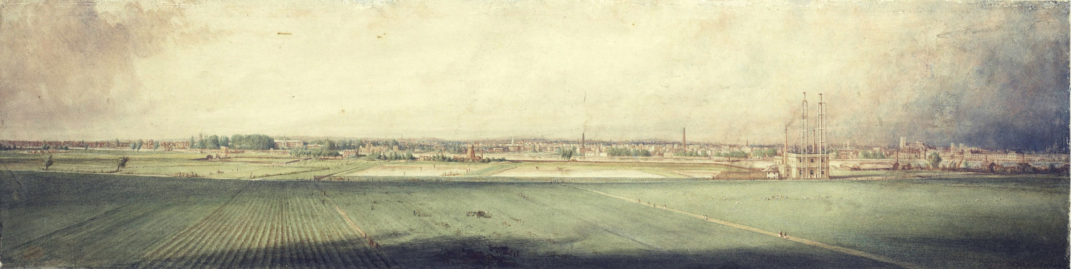
Robert Westall's watercolour of 1848, less than fifteen years before this perambulation, shows a rich alluvial plain being used for highly productive market gardens. It could almost be the Netherlands. The artist appears to have positioned himself on the raised Southampton railway line that crosses this low country to its then-terminus at Nine Elms.
[I have attempted in a fairly impressionistic way to locate Westall's viewpoint. Might be worth pursuing more rigorously.]
Notice in the centre a number of reservoirs of the Southwark and Vauxhall Water Company, mentioned above. The impressive white pumping station is just off centre. Already by 1862 there were more buildings in the view, but of course nothing like as many as many as by 1900. These reservoirs, which took in foul water direct from the Thames at this point, became notorious in [date?] when Dr John Snow demonstrated how they propagated cholera. This led to a move to extract water upstream [Seething Wells etc] and elsewhere. There is a useful history here:
The reservoirs were filled in and Battersea Power Station built there in [date?]. I have written some notes on the various companies here.
From the top of Wicke's-lane you bear in a south-easterly direction across Clapham Common [8] nearly to the corner of the Balham-road, and in a wall which divides the front gardens of two large gentlemen's homes you find a stone, almost hidden with ivy, with the significant initials, "B.P." [where? whose houses?]
Notice that Wicke's Lane is the boundary, not the wider straighter — and of course much younger — Cedars Road.
From this point you pass along the front gardens of all the houses on the south side of Nightingale-lane [9]. A row of old pollard oaks forms, in fact, the boundary lines at the road and about half of all the front gardens are in Battersea parish, and the houses in Streatham.
The journey across Clapham Common was rather difficult; the old boundary posts have either been removed or perished, but some knowing fellows who accompanied the expedition enabled the parochial officers to decide on those points, where good and substantial marks should be placed. This went down in the book, with the footpath.
These "good and substantial marks" were indeed eventually placed along the entire route — see e.g. Parish Boundaries: List of Stones and Marks 1886, published on Ascension Day 3rd June 1886 by order of the Board of Churchwardens and Overseers of St Mary Battersea (copy in hand), which I hope to write about sometime soon. Some of these markers are known to still survive, and there may be others concealed in people's gardens that it would be good to locate.
At the Wandsworth Common end of Nightingale-lane you see a respectable white-looking house, just painted inside and out [10]. Part of this house is in Battersea parish, and when the army collected in a confused heap before the front door, the servant, in her own expressive language, "wondered what was up."
The Churchwarden and Vestry Clerk were admitted, and the boys, who like seeing the inside of strange houses, were rather disappointed.
The conspicuous white post at the corner was impressed on the memory by the usual bumping, which, at various points, had distinguished the day's proceedings; and it is worthy of remark that twenty-five years ago the present Bishop of Bath and Wells cheerfully underwent the proper bumping at this spot. But in these degenerate days no clergyman accompanied the parish officers and little boys on this festive occasion, or gave by their presence that friendly counsel which all expect but few receive.
"Twenty-five years ago the present Bishop of Bath and Wells cheerfully underwent the proper bumping at this spot." This is surely a mistake. The Bishop of Bath and Wells at this time was Robert Eden, 3rd Baron Auckland, who has no known connection with Battersea.
The reference must be to undoubted local-boy Samuel Wilberforce (1805-1873). Never Bishop of Bath and Wells, he was at this time Bishop of Oxford [1849-1865], and then Bishop of Winchester until his death. It was in this latter position that he [inaugurated?] John Erskine Clarke at St Mary's Church in [1872?] — as noted by John Buckmaster in A Village Politician. At this time Battersea was in the diocese of Winchester.
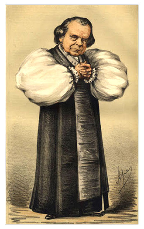
Samuel Wilberforce, son of anti-slave trade campaigner William Wilberforce, grew up in Broomfield House [later renamed Broomwood] between the commons and undoubtedly knew Wandsworth Common well — he was largely educated at home in his early years.
Wilberforce Junior's habit of wringing his hands led to Disraeli describing him as "unctuous, oleaginous, saponaceous"- hence his soubriquet "Soapy Sam".
A brilliant speaker but no scientist, he is remembered today mainly for being the object of Thomas Henry Huxley's [stinging put down...].

When asked by Wilberforce at the Oxford Debate in 1860 concerning Charles Darwin's Origin of Species whether he claimed descent from monkeys on his grandmother's or his grandfather's side, Huxley retorted that he would rather have a monkey as an ancestor than a man who "uses his great gifts to obscure the truth"...
From this post the journey proceeds to the south of the St. James's Industrial School [11], and in a delightful green lane, not like the one in Battersea, the boys and men seated themselves on the grass, and were plentifully supplied with cold ham and beef and bread and cheese, with a little wholesome beer.
["St James's Industrial School" — add notes, image(s), and links e.g. to the Survey section.]
Buckmaster was a committed abstentionist — can we assume that " a little wholesome beer" was such low-alcohol "small beer" that it was tolerable, even for children?
This was the great event of the day; how the little fellows did eat! it really gives a good-natured man a great deal of pleasure to see such a sight. The Churchwarden was laughing and saying good-natured things to the boys, and telling them to eat away.
But how rapidly the party increases at such a time. Suddenly you find great numbers of persons ready to join in the eating. Where do they come from? Surely a common cannot produce them? but there they are all declaring most solemnly they had been with the party all day, although it is the first time you ever saw them.
The rural dinner over, the churchwarden's health was drank in good spirit. This was not the time or the audience for speechifying, so Mr. Walton just thanked them for their kindness, and the party then proceeded just to the side of Mr. McKellar's front gate [12]
"McKellar's front gate" — this is the southernmost point of the perambulation, and what was then still thought of by many as the furthest extent of Wandsworth Common. Buckmaster appears to call it "Tooting Cross" [source].
Mr McKellar — Henry McKellar or M'Kellar — lived in Wandsworth Lodge. In spite of its name, it was not the entrance to a larger house behind but a very considerable house in its own right — perhaps the largest of any house round the Common — with substantial grounds and many greenhouses etc. McKellar had a passion for horticulture, for which he (or his gardeners) won prizes in [names of?] shows.
[Brief summary of McKellar's life story — master tailor in Westminster, spends time in India, returns wealthy, buys a copper mine in Wales, involves himself in major investment projects e.g. building Chelsea Bridge etc.]
His house was in Wandsworth (just), but in [c.1842 — exact date?] he had acquired from Earl Spencer all the fields along the west of what would later be called Trinity Road as far as the area of Common now called the Scope (today's Trinity Fields, Wandle and Brodrick Road etc).
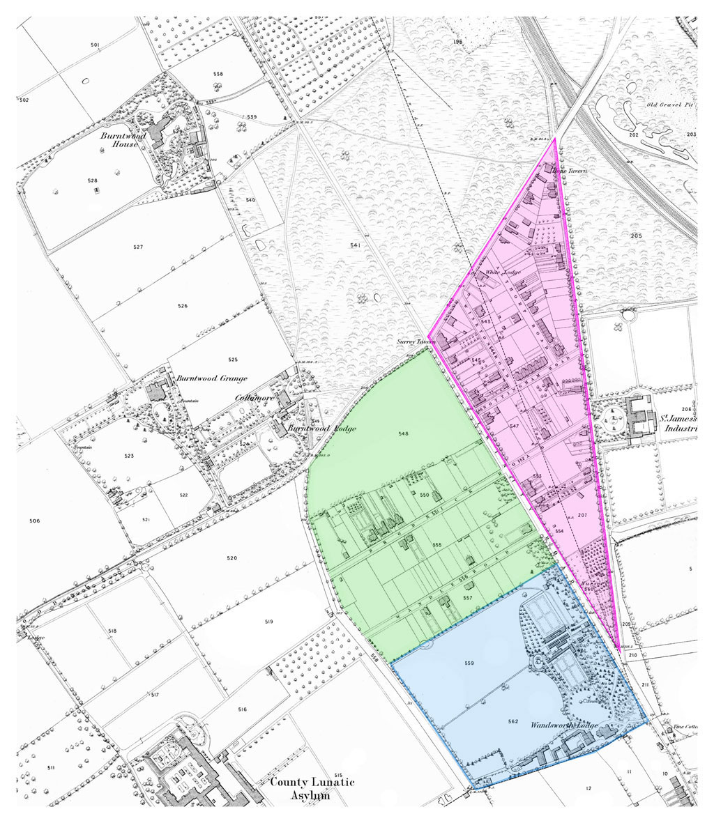
By 1868, the date of this OS map, roads have been laid out across McKellar's triangle (pink) and a number of houses have sprung up.Wandswrth Lodge is tinted blue.
He also bought a great triangle of about 22? acres between Trinity Road and St James's Road (now Drive), as far as Bellevue. This became known as "McKellar's Triangle".
There was considerable controversy about how he took this land — which of course many argued was not Spencer's to sell. It is also said that McKellar liberally dispensed alcohol to gypsies camped on the triangle, then used their drunkenness to justify his acquisition and enclosure of the triangle. Interestingly, he seems to have wanted mainly to protect his own view — he did nothing to "develop" the land. Building only started after his death in [date?], when [his wife? daughter?] sold it. See Survey of London, 50.? The Deep South.
There are today innumerable boundary markers in this area, since this is where Battersea West Heath meets Wandsworth East Heath, with Streatham manor to the south. The precise lines of the boundaries are intriguing, and probably highly significant. They certainly had a profound effect on the routes and size of roads in the area (Trinity Rd, St James's Rd/Drive, Balham Park Road etc), and on the social character of subsequent housing — for example, houses in Battersea and Wandsworth parishes were (and are) more substantial than those in adjacent Streatham.
Here they sung "God save the Queen," and then proceeded across the common [13], to about two hundred yards below the Clapham Common station [14]; here they crossed the line, and continued along the black fence into the road, and from there to the west side of the Union workhouse [15]. The wall dividing the Union from the Fishmongers Almshouses forms part of the western boundary of the parish.
[Add notes, images and links.]
Continuing this line across the Richmond Railway [16], into the Wandsworth-road, and from there down a lane on the east side of the Distillery [17] to the Thames, into Battersea-square [1], forms a general descriptive outline of the home bounds of the parish of Battersea.
The day was everything that could be wished, and there was no disagreeableness during the whole time.
After about eight hours the party arrived at the spot from which they started. Mrs. Walton provided cake and tea for a number of the boys in the evening. Among the party we noticed Mr. Perry, the churchwarden of St. George's, the school-master, Messrs. Poupart, Juer, W. Griffin, Buckmaster, and others.
[ADD INFO: Mr Poupart, a market-gardener, was for many years a prominent vestryman. Juer et al...]/p>
Send me an email if you want to 2indent on anything you've seen or read on the site, or would like to know more about something, or just want to be kept in touch.
Philip Boys (aka "HistoryBoys")