

[ADD better scans of the extra-ordinarily detailed LCC maps: Laurence Ward (ed), The London County Council Bomb Damage Maps 1939-1945 (2015) / https://www.amazon.co.uk/London-County-Council-Damage-1939-1945/dp/0500518254.,/p>

Black — Total destruction
Large circle — V-1 Flying Bomb
Purple — Damage beyond repair
Dark Red — Seriously damaged, doubtful if repairable
Light Red — Seriously damaged, repairable at cost
Orange — General blast damage, not structural, minor in nature
Yellow — Blast damage, minor in nature
Green — Clearance areas
Small circle — V-2 Rocket
Large circle — V-1 Flying Bomb (aka "Doodlebug", "Buzz bomb", ") ?mid-JUne 1944 to ?September 1944 Small circle — V-2 Rocket [Missile? Bomb? (aka "". Also "Flying Gas Mains".> [From 8 September, but not officially admitted until 10 November 1944. To 27 March 1945.)
[These maps are now online as part of theLayers of London project.]
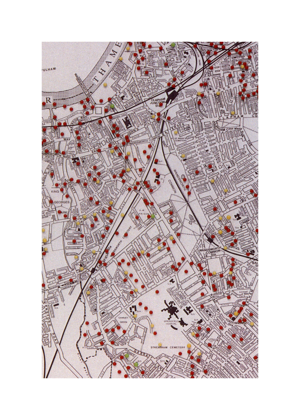
Bombs, 1939-1945
[Impressive but unreliable.]
[ADD reference to WHS and other sources.]
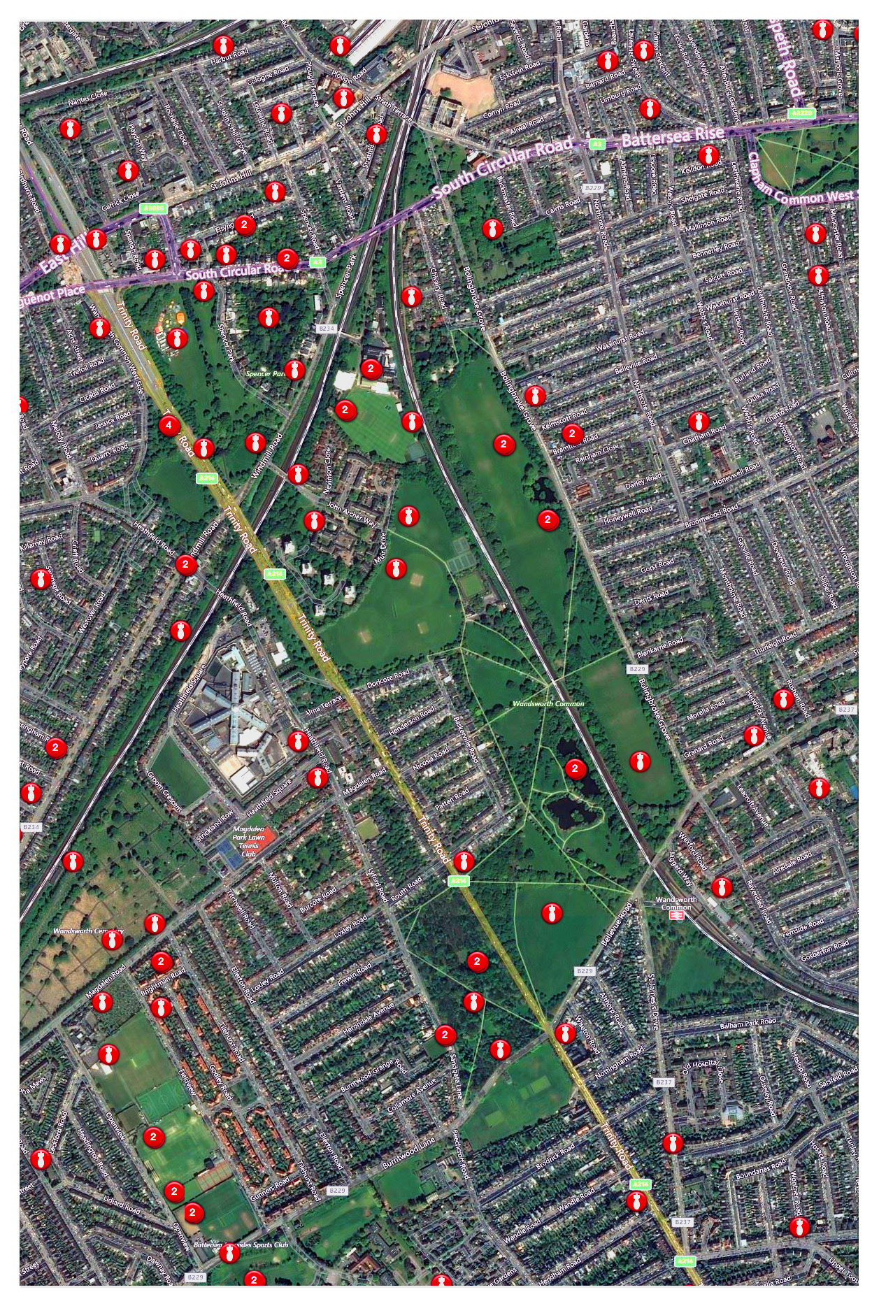
PB: Impressive as this map is, it is not reliable. I have not looked very closely, but I notice it e.g. does not show the Loxley Rd bomb(s), misplaces the Lyford Rd V-1, and includes others for which I have found no evidence.
Although the BL? LMA? suggest accessing this site for information, it was not woorking in August 2023.
The Battle of the Flying Bombs . . .

[I think this mixes two articles — separate them]
BATTLE OF THE FLYING BOMBS
Battersea and Wandsworth Bear Many Scars
Except for a possible few last shots the battle of the flying bomb has been won, although London has many scars to show and many lost citizens to mourn.
During 80 days bombardment 8,000 bombs were launched, of which 2,300 reached the London region. The record bag for the defences was on August 28, when out of 101 bombs which approached the coast, 37 were brought down and only four reached the London region.
In the first week 33 per cent, were brought down and the same proportion reached Loud la the last week 70 per cent. were brought down, and only nine per cent, reached London. South London suffered severely than North London.
Of the boroughs in the metropolitan area, Wandsworth was one of the wont Mt. Batter Sea, for as site, suffered as much as anywhere, ith the exception of Croydon.
The worst incident in Battersea was at Lavender Hill when a bomb hit a has and Mt extensive damage to shops and other pre'MAPS. The killed numbered 26. The total killed la the borough was 131. Wandsworth had 349 killed.
The figures which we are now able to give will dispose of a good many rumours which have at different times gained currency. Needless say these rumours circulated immediately after each incident greatly exaggerated the number of deaths.
FIFTY-TWO FALL
Between June 17 and August 17 ternoon cinema performance had 96 bombs fell in Battersea and an not started, so that there were only additional 18 which fell on the a few people in the building. perimeter caused damage in the
The number of persons killed — 1 In order to relieve the whole-time 31, and 228 injured persons were taken to hospital. No reliable wardens during their day duties. figures of minor casualties are availwardens were drafted in from Brigable. The total of houses destroyed tot, and have given very valuable wits 575. and were damaged help. Some stayed in the borough but are repairable. for a month. some came in .relays for a fortnight at a time; others
THE TWO WORST INCIDENTS
One of the have volunteered to stop for an indefinite time. The total number of One of the two worst incidents the wardens who have come from In Tennyson-street on a S unBristol is 38. day morning in the middle of the
A number of men have been day.hen people were in their drafted in to the Heavy Rescue Bee. houses 'having their midday meal. . vice from Scotland in order to inThe ether was in Lavender Will crease the strength of the parties. on a 'Thursday, also in the middle
Considerable help has been given of the day. when a bus was wrecked to the Civil Defence services at the by a bomb which fell on and deincidents by the National Fire Sermolished a number of shops and vice, the Home Guard, and the damaged the Pavilion Cinema and Women's Voluntary Services for the Public Library. Most of the Civil Defence. 'Maple killed were in the bus or in the shops. The Public Library was
WAR RESERVE POLICEMAN KILLED
One of those killed at Lavender Hill was War Reserve P.C. Hunt, who lived at 65 Bolingbroke-grove. He had been a war reserve constable for four years. His funeral was attended by Superintendent Miller, Chief Inspector Reid, Subdivisional Inspeotor Jones, and about 50 regular and reserve police. Police acted as pall bearers. P.C. Hunt left a widow and one child.
The position of the bombs and number of fatal casualties were as follows:
IN THE BOROUGH — FATAL CASUALTIES
82-86 St. John's Hill . . . . 1
Gwynne-road . . . . 1
Battersea Rlse Cemetery .. . . . . 3
88-94 Tennyson-street.. . . . . 19
Clapham Common, Speaker's Ground . . . . Nil
18 Petworth-street .. . . . . 9
63-67 Honeywell-road. .. . . . . 6
102-112 Nightingale-lane . . . . 4
Battersea Park, opposite Overstrand Mansions . . . . Nil
St. James's Drive, at Junction of Sarsfeld-road . . . . 6
6 Radstock-street — 2
Price's Patent Candle Co., Ltd., York-road . . . . Nil
Railway at back of Brottghton-street . . . . Nil
Bolingbroke-grove, between Wakehurst and Salcott-rds . . . . 1
Battersea Park, tennis courts . . . . Nil
River wall by Chatfield-road . . . . Nil
In river, opposite "Old Swan" public-house, Battersea Church-road . . . . Nil
Devereux-road . . . . 2
Sisters-avenue . . . . 5
Price's Patent Candle Co., Ltd., York-road . . . . 2
Gas Light and Coke Co., Nine Elms-lane . . . . Nil
Between Lubeck and Batten-streets . . . . 15
Newtown-street . . . . 5
Sabine-road, at junction of Brassey-square . . . . 4
Lavender Hill, at junction of Elspeth-road .. . . . . 5
Battersea Park, by children's paddling pool . . . . Nil
Battersea Park . . . . 1
Sarsfeld-road . . . . 2
Corunna-terrace . . . . 7
In the river, off Morgan Crucible Co., Ltd. . . . . Nil
Hampton and Co.Ltd.,Ingate-place . . . . Nil
Clapham Common, opposite Winsham-grove . . . . Nil
Gas Light and Coke Co., Nine Elms-lane . . . . Nil
Albert Palace Mansions . . . . 6
Lavender Hill . . . . 26
Those which fell outside the borough but caused damage within it were at:
Clapham Common, opposite Manchuria-road;
Nightingale-lane, behind the Jews' Home;
Bradmede School, Thessaly-road;
Clapham Common, near the bandstand;
Spencer Park, Wandsworth Common;
Ravenslea-road;
Mayford-road. Wandsworth;
Wilcox-road, Wandsworth-road;
Southern Railway, Nine Elms Hay Yard;
Fulham, near Power Station;
Lyford-road, Wandsworth Common;
Wandsworth Common, west of Trinity-road, south of Routh-road;
Grosvenor-road, Westminster;
In the river off Chelsea Basin (Lots-road);
Blandfield-street, Wandsworth;
West Side, Wandsworth Common.
Wandsworth
A total of 145 flying bombs fell on Wandsworth, 122 within the boundary and 23 on the boundary.
Casualties were: 349 killed, 709 seriously injured, some of them proved fatal, and 1,500 injured. 1,734 houses were demolished and 12,940 seriously damaged.
The number of houses damaged by blast was 27,010.
[BNA: Link]
NB This was [date] September 1944 — doodlebugs — They could not have known about the imminent use of V-2 rocket bombs . . . These started on ?, but were not officially announced until ? November . . . .Flying Gas Mains.
For useful background information, see Jim Slade's article,"WWII Air Raid Casualties in Battersea and Wandsworth", Wandsworth Historian, 82, Spring 2006 (pdf).
https://www.nationalarchives.gov.uk/help-with-your-research/research-guides/bomb-census-survey-records-1940-1945/ https://blog.nationalarchives.gov.uk/doodlebug/ https://www.layersoflondon.org/map/overlays/bomb-damage-1945SW11 26 V-1 and V-2 bombs 110 killed
SW12 19 74
SW17 25 105
SW18 27 54
[For boundaries of postcodes go to link and enter postcode: Link.]
"The higher death rates can generally be seen in the inner areas further out into the suburbs the death rate declined. This somewhat vindicates the governments policy of encouraging the Nazis to reduce their aim through false intelligence. At the time Herbert Morrison is quoted as saying "who are we to play God" but it would seem like a case of grim practicalities and the policy saved lives.
So for example West Wickham a suburban area had 14 V1's and a casualty (deaths ) rate of 0.71 per missile. However a tightly packed in urban area, for example Borough & Bermonsdey which suffered 25 missiles had a casualty rate of 7.96 per missile"
[This website does not cover SW17 or SW18 in as great detail as SW11 and SW12 (below). Does anybody? Where would we find the relevant documents? Presumably Fire and ARP Reports are in the LMA? Are copies in the WHerS?]
Some of the V-1 & V-2 listed in SW11 and SW12
SW11
London SW11 was hit by 24 V-1 Flying Bombs and 2 V-2 Rockets. 110 people were killed.
V-1 - St Johns Hill by Plough Way - 1 person killed - 17/06/1944 (16:00)
This was the first V-1 in Battersea and it demolished 2 shops and houses at 84-86 StJohns Hill. [ This must have been the V-1 next to the Granada cinema.]
V-1 - Honeywell Road between Honeywell and Broomwood Road : Northcross road junction - 6 - 23/06/1944 (18:55)
V-1 destroyed 8 houses and badly damaged a further 20
V-1 - Salcott Road,West end ,at Bolinbroke Road junction - 1 - 01/07/1944 (23:26)
V-1 demolished 10 houses and badly damaged a further 40. Bolinbroke Hospital also damaged.
V-1 - Devereux Road south end at junction with Thurleigh Road - 2 - 10/07/1944 (02:42)
8 houses demolished and 20 seriously damaged. Slight damage to surrounding property.
V-1 - Lavender Hill East Side Mossbury Road junction - 28 - 17/08/1944 (15:30)
Very serious V-1 incident. 17 shops and dwellings demolished, 20 shops and dwellings damaged.Small fire in Debris.Gas and Water mains fractured.
V-2 - Usk Road NW end of Usk road, York rd junction - 17 - 27/01/1945 - 16:04)
Serious V-2 Rocket attack 20 houses demolished, 50 badly damaged.
Source: https://www.flyingbombsandrockets.com/V-1_summary_sw11.html
___________
London SW12 was hit by 19 V-1 and No V-2's killing 74 people
SW12
V-1 - Mayford Road at NE of sharp bend. Site of current school [?] - 0
This V-1 is clearly shown on bomb damage maps but no corresponding Fire Brigade or CWG report can be found to verify it.
V-1 - Nightingale lane at corner of Hendrick Avenue - 12 people killed - 18/06/1944 (05:15)
The first V-1 in SW12 demolished a 3 storey building used as a nurses' home. It was the Jewish Home of Rest.
V-1 - Nightingale Lane - 5 - 26/06/1944 (12:55)
V-1 struck around 102 Nightingale Lane. Severe damage to 102-116 and 127-137 Nightingale Lane. Blast damage to surrounding property
V-1 - Sarsfeld Road - 6 - 27/06/1944 (22:01)
Demolished 5 houses and damaged 20 more. Boiler houses, Engineers' shops, laundry, and a number of wards damaged at St James Hospital.
V-1 - Ravenslea Road, end of Gosberton Road - 6 - 30/06/1944 (14:57)
89, 91 and 93 Ravenslea Road were demolished and 20 houses severely damaged by blast and fire.
V-1 - Mayford Road, north of junction with Calbourne Road - 4 - 06/07/1944 (13:15)
V-1 in Mayford Road demolished 6 houses and caused severe blast damage to 50 more.
V-1 - Sarsfeld and Boundaries Road - 2 - 21/07/1944 (10:20)
Demolished 10 houses and caused severe fire and blast damage to 30 more. Porters lodge to St James Hospital damaged by blast.
V-1 - NE quad of junction of Blandfield and Temperley Road - 3 - 03/08/1944 (00:00)
No further details available.
[For Cautley Avenue, SW4, see here: https://www.flyingbombsandrockets.com/V-1_summary_sw4and9.html]
During the week commencing 25/6/1944 125 V1 Flying Bombs fell on the area of South London analised. About 357 people were killed and thousands more badly injured. This is the log of the V1's that fell;
Stats by week. After week commencing 27/08/1944 a quiet period. But started up again a month later, starting 15/10/1944. Small numbers (1 to 5 V-2s) until the first week of January 1945, with 13. None after 25/03/1945.