Home › Sources › Brayley › Mantell’s geology
Last modified: 7 October 2026
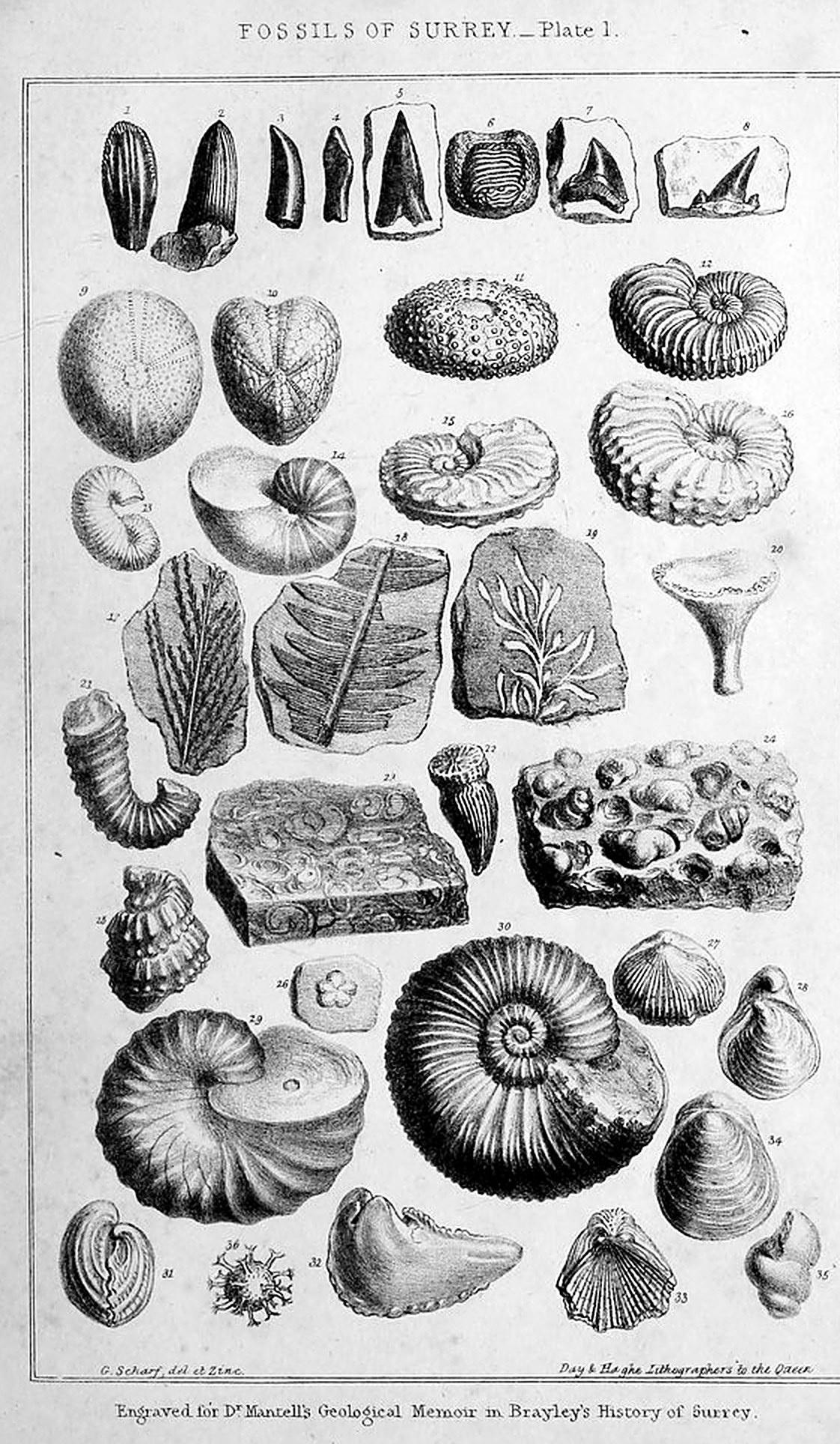
Transcribed in full, keeping Mantell’s spelling, capitals and punctuation, and checked line by line against the printed pages. The original page numbers are shown in grey, like this: [122]. Mantell’s footnotes are numbered as in the book and collected at the end. The three plates (two of fossils and the geological map with its sections) are reproduced from the scan at the places where Mantell describes them; click any of them to enlarge. Mantell (1790–1852), the discoverer of the iguanodon, lived for a time on Clapham Common, and he has a good deal to say about our own ground: the conglomerate blocks in the gravel of Clapham and Wandsworth commons (§10), the fossils dug out of the London clay when the Southampton railway cut across Wandsworth Common (§§18–19), the deep wells of Clapham, Tooting and Wimbledon (§15), and the collections of the Clapham ladies, Miss Henrietta Wollaston above all. The original scan is the Wellcome Collection copy on the Internet Archive.
[121] A Sketch of the Geology of the County of Surrey;
By Gideon Algernon Mantell, LL.D. F.R.S. etc.
Contents. 1. Introductory remarks. 2. Physical geography of the county. 3. Character of the soils. 4. Beds of peat. 5. Former geological notices of Surrey. 6. Mr. Middleton’s geological survey. 7. Geological memoirs relating to Surrey. 8. Geological character of the county. 9. Tabular arrangement of the strata. 10. Post tertiary deposits. 11. Tertiary formations of the London basin. 12. Bagshot sand. 13. Epsom mineral spring. 14. Fossils of Goldsworth-hill. 15. London clay. 16. Artesian wells. 17. Plastic clay. 18. Organic remains of the tertiary formations. 19. List of tertiary fossils from Surrey. 20. The chalk formation. 21. Course and extent of the chalk in Surrey. 22. The white chalk and flint. 23. Grey chalk marl and firestone. 24. Firestone beds of Godstone. 25. Firestone at Merstham. 26. Galt or Folkstone marl. 27. Shanklin or lower green sand formation. 28. Triple division of the Shanklin sand. 29. Strata at Tilburstow-hill. 30. Fuller’s earth pits at Nutfield. 31. Strata at Reigate and Red-hill. 32. Strata from Reigate to Leith-hill. 33. Strata at Dorking and Guildford. 34. The Hogsback. 35. Strata around Godalming and Farnham. 36. Strata at Hindhead. 37. Strata at Tucksbury-hill. 38. Organic remains of the chalk formation. 39. Fossils of the chalk formation of Surrey. 40. Zoological character of the chalk formation. 41. The Wealden formation. 42. Fresh-water limestone of the Wealden. 43. Organic remains of the Wealden. 44. Wealden fossils of Surrey. 45. Zoological character of the Wealden. 46. Retrospect of geological phenomena.
1. Introductory remarks.—But a few years since the natural history of a province was restricted to a description of the indigenous animals and plants, and a brief notice of the most remarkable mineral productions. The progress of scientific knowledge has, however, opened a new and inexhaustible field of inquiry; and the naturalist is now called upon, not only to describe the physical geography, and the Fauna and Flora of a country, but also to investigate the geological changes which the district has undergone, and determine the nature and succession of the strata, and of the various races of beings by which the land was tenanted in ages antecedent to all human history or tradition.
In a Topographical work, minute details of the characters of the rocks and organic remains comprised within the area it professes to illustrate, are not admissible; and the present sketch is, therefore, limited to a popular and concise survey of the geological phenomena of the county of Surrey; the reader who is desirous of more ample information will be referred, in the course of this notice, to the various scientific publications which have appeared on the subject.
2. Physical geography.—The county of Surrey comprises an area of about 759 square miles, according to the returns made [122] to Parliament under the Act for ascertaining the population, &c. in 1830. It is bounded on the east by Kent, on the west by Berks and Hampshire, on the north by the river Thames, and on the south by Sussex, with which county it bears a strict analogy in its geological structure. Its physical geography is, of course, dependent on the nature of the strata, and on the displacements which they have undergone since their original deposition. A chain of chalk-hills, called the North Downs, extends through the county from east to west, and presents an elevated plateau of variable breadth, intersected by numerous vallies, and divided transversely by deep ravines, through which the rivers Wey and the Mole pass, from the south of the Downs towards the north, and discharge their waters into the Thames; in like manner as the rivers of Sussex traverse the South Downs in their passage to the British Channel.1 To the south of the Downs a valley of clay (the vale of Holmesdale) occurs, which is succeeded by a range of sand hills which run parallel with the chalk, and gradually increase in altitude as they proceed towards the west, attaining at Leith-hill an elevation of nearly one thousand feet. To the north of the chalk-hills, the country gradually descends to the level of the alluvial valley of the Thames; its surface being diversified by mounds or hillocks of clay, loam, and gravel, of inconsiderable elevation.
3. Character of the soil.—The soil of Surrey is classed by agriculturists under the heads of clay, loam, chalk, heath, and gravel. The clayey soil forms the southern border of the county, and is, in fact, a continuation of the clay district of the weald of Sussex, as will hereafter be more particularly explained. To the north of the clay a tract of sandy loam succeeds, and stretches from east to west, spreading around Godalming, where it is of considerable extent. This soil is separated from the downs, throughout the greater part of its course, by a narrow belt of dark bluish clay, or loam, called “malm” or “black land,” which is remarkably stiff and tenacious. It is thus described by Mr. Young: “this soil is an excessively intractable calcareous loam on a clay bottom; it adheres so much to the share, and is so very difficult to plough, that it is not an unusual sight to observe ten or a dozen stout oxen, and sometimes more, at work upon it. It is a soil that must rank among the finest in this or any other country; being pure clay and calcareous earth.”2
[123] A broad expanse of calcareous or chalky soil spreads over the North Downs and adjacent vallies, having here and there beds of gravel and loam: but to the east, considerable tracts of heath, loam, clay, and gravel prevail, and extend to the Thames; the chalk, which is the foundation-rock of the district, lying at variable depths beneath the strata comprehended in the geological term of London clay. In the western division barren heaths, consisting principally of sand, prevail; as at Bagshot, Chobham, Byfleet, Ripley, and Oatlands.
4. Peat.—Beds of peat exist in the parishes of Ash, Purbright, and Worplesdon, on the north side of the chalk-hill that extends from Guildford to Farnham. At Purbright the peat moss is from twelve to fourteen feet in depth, in which trees of a considerable size are imbedded; these consist of oak, fir, birch, alder, and hazle; the oak and fir are black throughout, and are perfectly sound.3
Extensive ponds occupy depressions or basins in the clayey and loamy soils at Shire, Frensham, Godstone, &c.; and mineral springs occur at Epsom, Cobham, Streatham, Kingston, Dulwich, and Norwood.
Such are the principal phenomena observable in a survey of the surface, and subsoil of this district. With the exception of superficial and unimportant changes effected through the lapse of ages by atmospheric influences, and in the low districts by partial inundations, and the modifications induced on the surface by human art and industry, the country has probably undergone no material change since the period when it became elevated from the waters of the last ocean beneath which it was submerged, and when the Thames and its tributary streams first began to flow. We now proceed to inquire into the nature, order of succession, and the mineral and fossil productions of the various strata of which this district is composed.
5. Notices of the geology of Surrey.—An account of numerous fossils obtained from various parts of this county, by the late John Smith Budgen, esq. of Dorking, together with specimens discovered by Mr. Waller of Guildford,—with notes on the “Mineralogy of Surrey” by John Middleton, esq. of Lambeth, are inserted by Manning and Bray in the third volume of their elaborate work; and these papers present an epitome of all that was then known of the geological structure of the district.4 These contributions are highly creditable to their respective authors; and from the list of organic remains, [124] arranged according to the present state of our knowledge, and the memoir by Mr. Middleton, a correct notion of the geology of the county may be obtained. It is due to these first explorers of the fossil remains of Surrey, to give a brief notice of their labours. The fossils enumerated by Messrs. Budgen and Waller, consist of wood, supposed fir-cones, corals, shells, echini, and the teeth and other remains of fishes. The supposed fir-cones were found in the hard chalk of Dorking, and are termed coprolites; they are the intestinal remains of fishes (see Dr. Buckland’s Bridgewater Essay). Wood in flint is mentioned, from the chalk near Croydon, and in septaria from the London clay. Small corals, the nature of which is not stated, were found in the chalk-pits at Sutton and Croydon. Belemnites, pectens, oysters, and anomiæ, are enumerated, from the chalk of Sutton, Croydon, Guildford, Dorking, and Mickleham downs; and large oysters from Headley common. Echinites (or petrified sea-urchins) of various kinds, are described as occurring at Sutton, Croydon, Horsley, Dorking, Guildford, and Mickleham downs. The marsupite (pl. 2, fig. 11), described by the name of Tortoise-encrinus, was found in a chalk-pit on Mickleham downs by Mr. Waller; who states, that he had likewise discovered some joints of a species of star-fish. Teeth of sharks from the London clay at Richmond, and from the chalk at Dorking, Croydon, and Guildford, are also enumerated; and “part of a fish about the size of a tench, the head part with the scales on it; it is bedded in chalk, from Croydon, the left-hand pit from the town.” Jaws of fish with teeth are specified as from the limestone chalk of Dorking and Croydon.
6. Mr. Middleton’s survey.—The following summary of the mineralogical survey by Mr. Middleton, will serve to show the accuracy of that gentleman’s observations. He states, that the most recent mineral formations occur on the north side of the county, the older strata appearing at the surface on the south. He arranges the various deposits under five heads.—
| feet. | |
| 1. Brick earth, lead-coloured clay, and sand, above the chalk. Estimated thickness, about | 300 |
| 2. Chalk | 800 |
| 3. Blue marl | 30 |
| 4. Fuller’s earth, sand | 413 |
| 5. Weald measures | 457 |
| Total thickness | 2000 |
[125] 7. Geological memoirs.—Since the completion of Manning and Bray’s History, several notices on the geology of various localities in this county have appeared.5 The writer of this brief sketch introduced some general observations on the geology of Surrey in his “Illustrations of the County of Sussex,” and other works relating to the south-east of England;6 and Messrs. Conybeare and Phillips gave many interesting details in their valuable work.7 Mr. Smith published a geological map of Surrey; and the nature and distribution of the strata are accurately delineated in the splendid geological map of England and Wales by Mr. Grenough. But by far the most important information, relating to the geology of this district, will be found in the elaborate “Memoir on the Strata below the Chalk,” by Dr. Fitton, in the fourth volume of the Transactions of the Geological Society of London,8 to which frequent reference will be made in the course of this essay.
8. Geological character of the county.—The strata of the county of Surrey constitute three principal groups, namely: first, the Wealden, which is the lowermost and most ancient series of deposits; secondly, the Chalk, which is superimposed thereon; and thirdly, the London clay or tertiary beds, distributed in basins or depressions of the chalk. Upon these last named strata there are, here and there, accumulations of ancient drift, consisting of loam, gravel, and sand, which are designated Post tertiary detritus, or diluvium. These various [126] deposits admit of subordinate divisions, which are distinguished by their peculiar mineralogical characters and organic remains.
It is here necessary to premise, that the most ancient rocks of the south-east of England were originally deposited in a direction nearly horizontal; and that subsequently to the formation of the chalk, the lowermost strata must have been elevated by a subterranean movement, which appears to have extended in a line from east to west, by which the superincumbent beds have been disrupted, and thrown into an inclined position on each flank of the axis of elevation (vide pl. 3, No. 5); hence the chalk and subordinate strata in Sussex dip to the south-east, and the corresponding deposits in Surrey to the north-west.9 But for this displacement of the strata, the entire area comprised in this survey would have presented an expanse of chalk, and the wealden, which are the lowermost or inferior beds, would have been entirely concealed from view, and unknown, unless borings or other means of exploration had been employed. But the present position of the rocks offers every facility for their examination; and the observer, passing along any of the principal roads from Brighton to the metropolis, traverses in succession the entire series, from the most ancient to the uppermost or newest deposits. Upon leaving Sussex and entering on the northern limits of this county, the traveller crosses the clays and limestones of the weald, and the sand-ridge, as at Reigate (see pl. 3, No. 4), and arrives in the valley formed by the argillaceous beds of the Shanklin sand. He then ascends the escarpment of the North Downs, and traverses the chalk, the surface of which is in many places obscured by beds of gravel and loam, till approaching within eight or ten miles of London, he enters on the clay district of the metropolis.
9. Tabular arrangement of the strata.—A general idea of the nature and order of superposition of the strata may be obtained by referring to the following tabular arrangement, which, for the convenience of description, commences with the uppermost deposit. This table exhibits the rocks in the order they would present if they had undergone no displacement, but were lying one upon the other, as they were originally deposited.
| Formations. | Subdivisions. | Mineralogical Character. | Organic Remains. | Localities. |
|---|---|---|---|---|
| Post tertiary deposits. | Superficial gravel, loam, &c.; drift sand; blocks of conglomerated flint-pebbles. | Bones and teeth of the elephant, rhinoceros, horse, Irish elk, &c. | Clapham, Wandsworth and Wimbledon Commons; Petteridge Common. | |
| London tertiary formation. | Bagshot sand. | Silicious sands and sandstone; foliated marls; concretionary masses of flint-pebbles. Blocks of the “Grey wethers.” | Teeth of saw-fish, sharks, rays, and other fishes; marine shells. | Goldsworth-hill, Bagshot-heath, and Epsom. |
| London clay. | A tenacious blue clay; layers of septaria. Pyrites; sulphate of lime; fossil resin. | Bones and teeth of extinct mammalia; bones of birds, serpents, crocodiles: fishes, crustacea, nautili, and other marine shells. Wood, plants, and seed vessels. | Richmond, Wandsworth and Clapham Commons; Tooting, Norwood, &c. | |
| Plastic clay. | Clay, sand, shingle and loam; masses of conglomerate composed of flint-pebbles. Oyster-shell conglomerate. | Marine and fresh-water shells, crustacea, fishes; beds of oyster shells. | Headley near Reigate, Epsom, and Walton-hill. | |
| Chalk formation. | Upper chalk, or chalk with flints. | Nodules and veins of flints; pyrites; chalcedony; calcareous spar. | Marine shells; ammonitæ, nautili, belemnitæ; fishes; crustacea; echini; bones of saurians and turtles; corals and other zoophytes; wood; marine plants. | The North Downs; near Reigate, Croydon, Guildford, Godstone, Merstham, &c. |
| Lower chalk, or chalk without flints. | Pyrites; calcareous spar; seams of marl; flints very rarely; quartz pebbles. | Marine shells, corals, and fishes; echini; wood; marine plants. | (as above) | |
| Grey chalk marl. | Calcareous spar; pyrites. | Marine shells; ammonitæ, nautili, turrilitæ, and scaphitæ; echini; teeth of fishes, as sharks, rays, chimera, &c. | The North Downs; near Reigate, Croydon, Guildford, Godstone, Merstham, &c. | |
| Firestone, or upper green sand. | Marl with an intermixture of green sand; coarse calcareous sandstone; veins of calcareous spar. | Marine shells; inoceramus, pecten, cucullæa, ostrea, solarium; syphonia; fuci. | Merstham, near Godstone, and Reigate. | |
| Galt, or Folkstone marl. | A stiff blue marl; with thin layers of reddish ochreous marl, gypsum, pyrites. | Ammonitæ and nautili with their pearly shells preserved; nuculæ, inocerami, belemnitæ, rostellariæ; wood with teredines. | Bletchingley, near Merstham, and Reigate. | |
| Shanklin, or lower green sand. | Sand and sandstone of various colours, green, grey, white, and ferruginous. Layers and concretions of chert, ironstone, Fuller’s earth: sulphate of barytes; crystallized quartz; fibrous gypsum. | Marine shells, generally in the state of casts; ammonitæ, nautili, trigoniæ, venericardiæ; teeth and scales of fishes; crustacea; coniferous wood and fir cones. | Tilburstow-hill, Nutfield, Reigate, Dorking, and Godalming. | |
| Wealden formation. | Weald clay. | Septaria of argillaceous ironstone; blue clay with beds of fresh-water limestone (Sussex marble); thin layers of sand; lignite. | Fresh-water crustacea and mollusca, as paludinæ, cyrenæ, cyclades, &c.; teeth and scales of fishes; terrestrial plants. | Charlwood, Horley, Heaver’s wood, Earl’s wood, Capel, Ockley, Atherley, Oakwood-hill, &c. |
| Tilgate beds. | Fawn coloured sand and sandstone; calciferous sandstone or Tilgate grit; blue clay and marl; lignite. | Fresh-water shells; fishes; bones and teeth of iguanodon, hylæosaurus, megalosaurus, and other reptiles, in abundance; bones of birds; fresh-water and marine turtles; stems and leaves of arborescent ferns and other monocotyledonous plants. | (as above) |
[In the printed table the organic remains and localities of the two chalk subdivisions, and of the two Wealden subdivisions, are bracketed together; here “(as above)” marks the shared entry.]
[129] 10. Post tertiary deposits, or diluvium.—It would extend this notice to an inconvenient length, were I to enter upon the description of the modern alluvial deposits which are spread over the surface of the ancient formations, on areas formerly occupied by the waters of the Thames. It will suffice to mention, that beds of silt and loam, containing the recent species of shells which still inhabit the neighbouring river, form the subsoil of the meadows and low lands that skirt its banks. On penetrating this modern soil, we invariably find clay, loam, or gravel, in which there are no traces of recent species of fluviatile shells, but bones and teeth of gigantic elephants and rhinoceroses, with the antlers and bones of the Irish elk,10 of one or more species of horse, deer, buffalo, and other pachydermata; an assemblage of organic remains common in similar deposits all over England and the continent.11 An interesting discovery of the greater part of the skeleton of an elephant with the teeth and tusks, and the teeth and many bones of a rhinoceros, took place at Petteridge common, nearly twenty years since; these remains were imbedded in loam, in the midst of an extensive accumulation of gravel. Happening to visit the spot soon after the disinterment of these fossils, I obtained two grinders of the rhinoceros, which are still in my possession, and in a fine state of preservation (see Pl. 2, fig. 18); the other relics were, I believe, carefully preserved by Mr. Constable. Immense quantities of fossil bones and teeth of these large extinct mammalia have been occasionally found in the ancient gravel and loam around London; and specimens are preserved in the British Museum, and in the museums of the Geological Society, of Mr. Gibson of Bow,12 and in other private collections.
The gravel belonging to this formation in Surrey, so far as I have had an opportunity of examining it, is almost wholly composed of chalk-flints more or less broken and rolled. Large irregular blocks of conglomerate formed of this drift, cemented together by an infiltration of iron, are imbedded in the loose sand and gravel of Clapham and Wandsworth commons, and other places in the vicinity; masses of this conglomerate are employed with good effect in grotto and rockwork, as in the beautiful grounds of John Allnutt, esq. of Clapham common. I have not discovered any bones of mammalia in this rock; but it is probable, that more diligent research would be rewarded with specimens like those which occur in the coombe-rock of Brighton cliffs.13
[130] In the flints and pebbles of this drift may be found many of the silicious fossils of the chalk formation; of which there are numerous examples in the interesting collections of Mrs. Allnutt, Miss H. Wollaston, Mrs. Potts, Miss Graham, and other residents on Clapham common. Among these fossils are casts of the usual echini, plagiostoma, pectens, spirolinites, and other shells of the chalk; and remains of corals, and other zoophytes. Nor must I omit to mention those minute but highly-interesting objects, the fossil infusoria, which abound in the flints; one specimen, highly magnified, is here figured (Pl. 1, fig. 36); the original is invisible to the unassisted eye.14 Thus, with merely a common lens, the attentive observer may find an inexhaustible source of amusement even in the beds of gravel spread over the wastes and heaths of this district.
11. Tertiary formations of the London basin.—In the deposits above described, the remains of elephants and other large mammalia constitute the most striking character. The beds rarely exhibit indications of tranquil deposition, but are heaps of water-worn materials, which have been transported by the sea, or by river-currents, and accumulated in estuaries, or thrown up in bays and creeks by the waves. The formations which succeed, are composed of regularly stratified deposits, with interspersions of alluvial detritus. The series consists principally of layers of stiff blue clay, forming a bed several hundred feet in thickness, abounding in marine shells, and having strata of sand above, and of sand and plastic clay with fresh-water shells, in some localities, beneath. The area occupied by these deposits is designated the London Basin;15 the strata are grouped as follow:—
1. Bagshot sand, and clay; the uppermost or newest deposit.
2. London clay.
3. Plastic clay.
12. Bagshot sand.—(Geological map, and the sections, Pl. III. No. 1—6.) Beds of silicious sand and sandstone, associated with thin layers of marl and clay, occupy extensive areas on the London clay; and as they are largely developed around Bagshot, the term, Bagshot sand, is employed by geologists to designate the group. The sand of Bagshot-heath occupies a district of considerable extent; it covers the London clay from near Finchley on the north, to Hampstead-heath, and forms part of the eminences on which Highgate and Hornsey are built. It appears at Egham on the north, extending south, though not uninterruptedly, to near Guildford; and from the vicinity of [131] Kingston to about seven miles west of Bagshot, spreading over part of Windsor forest.16 These strata form or cover several eminences in Surrey; as on the south of Esher, part of Bagshot and Frimley heaths, Purford heath, Chobham ridges, and Romping downs, north of the Hogsback, and St. George’s hill on the south of Weybridge: the greatest elevation, which does not exceed five hundred feet, is at Tucksbury-hill and Beacon-hill camp, north of Farnham (sec. No. 1). From the silicious character of the strata, the soil is, for the most part, a barren and unimprovable sand, supporting only heath and furze, and giving rise to the numerous uncultivated wastes and heaths around the metropolis; except where the argillaceous beds rise to the surface, and form verdant spots, which appear like oases in the desert. Mr. Warburton remarks, that “at its eastern extremity the Bagshot sand forms a chain of detached hillocks, and in its central part an elevated continuous plain, which are strongly contrasted by their barrenness with the country that surrounds them; such, indeed, is the character of the vegetation and the general appearance of sterility in the worst parts of the district, that when the adjacent fertile country is hidden from view, one might suppose oneself transported to a desolate mountain moor in the border country.”17
In the upper beds, ochreous sand prevails; but at a lower level, layers of foliated greenish clay alternate with the sand; and to the north of Chobham Park, the argillaceous deposits predominate, and are worked for the manufacture of bricks and coarse pottery. Descending the declivity to the south of Chobham Park, the lowermost beds of the Bagshot sand are displayed; these consist of alternations of white, sulphur-yellow, and pinkish foliated marls, interspersed with grains of green sand, regularly stratified, and containing numerous shells, the genera and species of which have not been accurately determined.18 The entire thickness of this division of the strata is about forty feet.
Large masses of the silicious sandstone, of which loose blocks occur on the downs of Wilts, Berks, &c. and are called the Grey Wethers, are found on Bagshot-heath and other localities of the sand in this county; and also stony concretions of this sandstone intermixed with green sand, and solid chalk-flints.19
13. Epsom mineral water.—Beds of sand and gravel of the plastic [132] clay, constitute the subsoil of the vicinity of Epsom; the town standing near the junction of the lowermost tertiary strata with the chalk, which rises with a gentle ascent to the southward, and forms the downs on which the far-famed race-course is situated: to the northwest the London clay appears. The celebrated mineral springs of Epsom were on the common between Epsom and Ashtead; the water receiving its saline impregnation from penetrating the beds of clay. “It is said, that in the early part of the seventeenth century, attention was first directed to the peculiar property of the water, from a pool having been made for cattle, and the water being refused by the animals. In 1640 the Epsom springs had attained a high reputation; and although the salts prepared from them sold at five shillings an ounce, so great was the demand that the quantity required could not be supplied, and other salts were sold under the same name!”20 Epsom salt is a sulphate of magnesia, consisting of sulphuric acid combined with magnesia, and is now usually obtained from sea-water.21
14. Goldsworth-hill.—Goldsworth-hill, four miles north of Guildford, which consists of Bagshot sand, has lately afforded some interesting organic remains. The summit of this hill has been cut through by the London and Southampton railway, and in a bed of greenish sand exposed by the section thus formed, Mr. Sibthorpe, of Guildford, discovered a few imperfect casts of shells, and the remains of several genera of marine fishes. The most numerous are the teeth of sharks, and the teeth and palatal bones of rays, similar to those which abound in the London clay. With these were found the remains of three kinds of cartilaginous fishes, vertebræ of several bony fishes, and teeth of three unknown genera of fishes. The most interesting discovery is a large tooth of a saw-fish, the only known example of the genus, Pristis, in a fossil state hitherto found in England. A portion of the carapace of a fresh-water turtle (Emys) was discovered by Mr. Sibthorpe in the same bed.22
15. London clay.—This clay in the neighbourhood of the metropolis, and throughout the greater part of its extent in Surrey, forms a dark-bluish stiff soil, and has occasional intermixtures of green and ferruginous sands and variegated clays. It abounds in layers of spheroidal nodules of indurated argillaceous limestone, called septaria, [133] which are internally traversed by veins of calcareous spar and sulphate of barytes, disposed in a radiating manner from the centre of the nodule to the circumference. Shells and other organic remains frequently form the nuclei of these nodules, which are used in prodigious quantity for Roman cement.23 The septaria are commonly disposed in horizontal layers, and lie at unequal distances from each other. Brilliant pyrites, and crystallized sulphate of lime or gypsum, abound in the clay. The distribution of this vast argillaceous deposit over the chalk of Surrey is shewn in the map, and its relative position, in the sections from Tucksbury-hill to Hindhead. (Pl. III. No. 1.) The total thickness of the clay, in some situations, is estimated at nearly one thousand feet; but in Surrey, the wells sunk through it give depths varying from one to five or six hundred feet. It has been perforated by wells at Clapham,24 Stockwell, Tooting, Brixton, Richmond Park, &c. At the seat of Lord Spencer at Wimbledon common, a well was sunk to the depth of five hundred and thirty feet.
From the prevalence of various saline minerals in the clay, as sulphate of iron and lime, phosphate of iron, and sulphate of magnesia, the water issuing from the porous strata of this bed, is unfit for domestic purposes, and various expedients have been employed to obtain a better supply.
16. Artesian wells.—From the alternation of porous sandy strata with stiff impervious clay, throughout the London basin, the district it occupies is particularly favourable for obtaining water by the borings termed Artesian wells, by which perennial fountains are obtained from the natural reservoir of water in the lowermost arenaceous deposits. The nature of these springs is easily explained.25 The beds of sand beneath the clay are fed by the rain which descends on the uncovered margin of the basin, and a reservoir of water thus gradually accumulates beneath the central plateau of clay, through which it cannot escape. Now, if this bed of clay be penetrated, either by natural or artificial means, the water must necessarily rise to the surface, and may even be thrown up in a jet to an altitude which will depend on the level of the fluid in the subterranean reservoir. Such is the [134] phenomenon observable in the artesian wells around London, as at Tooting, Hammersmith, Fulham, &c. The blue clay confines the water contained in the sands beneath: the engineer perforates the clay, taps this natural tank, and introduces tubes for the passage of the pure element, and the exclusion of the brackish water that may ooze from the clay above. The wells sunk into the London clay yield no water; but the sands alternating with the clay afford a supply, the quality and quantity of which depend on the local nature of the rock; but the wells which reach to the sand of the plastic clay beneath, and the still deeper borings that extend to the chalk, afford an abundant source.
17. Plastic clay.—Beneath the vast argillaceous deposits above described, and interposed between them and the chalk, there occur, in many places, strata of sand of various shades, as green, fawncolour, &c. alternately with layers of a bluish plastic clay, and having very constantly a bed of green sand with oyster shells and pebbles, which, in some localities (as near Bromley), constitutes a coarse and hard rock. To this group the term, Plastic clay, has been applied, in conformity with the nomenclature of the French geologists. Lignite, leaves, and fresh-water shells, abound in some of these beds.26 At Ewell several layers of the plastic clay occur, and are seen cropping out from beneath the London clay. The uppermost stratum is of a reddish colour with blue veins: the next, clay resembling Fuller’s earth, three feet thick, which rests on sand of a brown colour; beneath which is a bed of white sand, that reposes on the chalk. These sands and clay, mixed in various proportions, are manufactured into tiles and bricks, for ovens and furnaces, where great heat is to be withstood. The lowermost sand is, also, seen to rest on the chalk on the south side of Addington hills, and at Crowhurst.27 Hollows and fissures filled up with similar sand occur in the chalk-pits near Reigate, indicating a former capping of this stratum over the adjacent North downs. At Reading in Berkshire, and at Sundridge Park near Bromley in Kent, extensive layers of sand and pebbles, with an immense deposit of oyster shells, form the lowermost tertiary strata of the London basin. In these beds, large masses of a hard coarse conglomerate or breccia are found, consisting of oyster shells, sand, and pebbles, consolidated by a calcareous cement derived from the detritus of the shells.28 At Headley, a few miles from Reigate, a similar [135] accumulation of oyster shells occurs in loose sand, with pebbles of the same character as those which compose the shingle of Blackheath, Greenwich, and other localities.29
18. Organic remains of the tertiary formations.—The tertiary formations of the London basin have long been celebrated for the immense number and variety of their organic remains. The distribution of the fossils is, however, very variable; some beds being entirely barren, and even a stratum abounding in remains through part of its extent is found wholly destitute of any in other localities.
For an account of the animals and plants that have been discovered in the London clay, Dr. Buckland’s Bridgewater Essay may be consulted;30 it must suffice for our present purpose to state in general terms, that the organic remains consist of the teeth and bones of several extinct mammalia; bones of birds, serpents, turtles, crocodiles, and other reptiles; many genera of fishes, crustacea, and a few zoophytes; immense quantities of marine shells, of several hundred genera and species; and leaves, seed vessels, stems of plants, and rolled masses of wood perforated by boring-shells.31 In Surrey, the usual fossils of the clay have been found wherever the strata have been explored, by wells, railway sections, and other excavations. The section across Wandsworth common, formed by the line of the Southampton railway, afforded a highly-interesting suite of specimens, of which a good series is preserved in the choice cabinet of Miss Henrietta Wollaston of Clapham common. A few of the most characteristic fossils from Wandsworth common are enumerated below.
19. Fossils from the London clay, Wandsworth common.—
1.—Nautilus imperialis: Pl. 1, fig. 14.32 This beautiful shell sometimes attains eight or ten inches in diameter: the shell itself is usually preserved; the septa and the siphuncule are shewn in the sections made by accidental fractures of the specimens: these are often powdered over with brilliant pyrites, and sometimes with crystals of sulphate of lime.33
2.—Avicula media: Sowerby’s Min. Conch. vol. i. tab. 2.
3.—Ampullaria.
4.—Cassis carinata: Min. Conch. tab. vi.
[136] 5.—Modoila elegans: groups of this shell occurred in the septaria: Pl. 2, fig. 3.
6.—Pectunculus decussatus: Min. Conch. tab. xxvii.
7.—Teredo antenautæ: Pl. 2, fig. 9. Masses of wood, more or less perfectly preserved, and perforated by a boring-shell allied to the teredo, are found everywhere in the London clay. Dr. Woodward describes masses of this kind, as occurring in the great clay-pits at Richmond, and terms them “the piped-waxed vein,” from the amber-coloured pipes formed by an infiltration of calcareous spar into the tubular hollows made by the teredines. Miss Wollaston’s cabinet contains several fine specimens from Wandsworth common; some examples are sufficiently hard to bear cutting and polishing, and in that state present a beautiful appearance from the section of the sparry tubes, and the rich grain of the wood they traverse.
8.—Natica glaucinoides: this small species occurs in immense numbers.
9.—Tellina.
10.—Venus or astarte.
11.—Voluta musicalis: Pl. 2, fig. 1.
12.—Dentalium.
13.—Cardita.
14.—Cardium semigranulation: Pl. 2, fig. 7. Many specimens of this beautiful shell were found in the clay.
15.—Rostellaria.
16.—Pleurotoma: Pl. 2, fig. 8.
17.—Pyrula.
18.—Murex.
19.—Nucula: Pl. 2, fig. 6.
20.—Venericardia.
21.—Solarium conoideum.
22.—Pinna affinis: Min. Conch. tab. 313, fig. 2. Very fine examples of this beautiful shell were collected by Miss Wollaston.
23.—Pholadomya intermedia.
24.—Vertebræ and teeth of sharks.
25.—A species of Astacus.
26.—Turbinolia: Pl. 2, fig. 16.
27.—Murex trilineatus: Pl. 2, fig. 2.
28.—Cancer Leachii: Pl. 2, fig. 19.
29.—Conus: Pl. 2, fig. 4.
The seed vessels, associated with the stems and branches of trees, which are found so abundantly in the London clay in the Isle of Sheppey, amount to several hundred species, and are there accumulated in such quantities as to lead to the supposition, that they were drifted by currents into the gulf of the London basin,34 from an archipelago of islands clothed with trees and shrubs of a tropical character, and of extinct species and genera. Some of these fossils are related to the areca, cocoa, and other trees of the palm family. I am not aware that any remains of this kind have been found in Surrey; but examples of the fossil resin, discovered in the clay at Highgate, and which, there can be no doubt, is of vegetable origin, have been collected at Richmond. This substance appears to have been well known to Dr. Woodward, more than a century ago: he describes “two samples of amber, brown and foul, found thirty feet deep in the pit where they dig clay to make tiles at Richmond. The workmen call it rosin. Exposed to fire, this sort burns, emits an oil, and a smell exactly like that of amber, but exerts no electric attractive power when rubbed and heated.”35
[137] The following section of the strata at Richmond has been contributed by a correspondent of the editor.—
| 1. | Vegetable mould, from | 1 to 2 feet. |
| 2. | Loam and gravel, with chalk-flints but slightly rolled | 8 “ |
| 3. | A thin seam of marl | |
| 4. | Loose sand of a reddish colour | 8 “ |
| 5. | London blue clay with septaria | 200 “ |
| 6. | Plastic clay, red, green, and bluish black | 30 to 50 “ |
| 7. | Chalk |
In some parts of the bed of the river near Richmond the soil is washed away to the blue clay, in which large masses of fossil wood, perforated by teredines, are imbedded; good specimens are often obtained by dredging for gravel.
Such are the principal geological phenomena observable in a survey of the tertiary formations of the county of Surrey; these strata have evidently been formed in the bed of an ancient ocean that swarmed with nautili and other marine animals of extinct species, whose recent analogues inhabit tropical seas: and we have proof that the dry land was tenanted by mammalia of genera and species now extinct, and clothed with groves and forests of trees and plants no longer known in Europe. We have seen, too, that at a still later period, and yet at an epoch incalculably remote, extinct species of elephants, rhinoceroses, elks, and other large mammalia, were the inhabitants of European regions, which are now either entirely swept away, or metamorphosed by subsequent physical changes; for the accumulations of gravel, loam, and sand, in which these remains are imbedded, cannot be considered as the sites of the dry land on which these lost beings existed; on the contrary, they are the sediments of ancient lakes,—the deltas and estuaries of former rivers and seas; they are composed of the detritus of the land transported from a distance.
20. The chalk formation.—We now advance to the examination of the foundation rock of the strata above described, the Chalk, comprising under that term the following subdivisions:—
1. Upper chalk, with flints.
2. Lower chalk, without flints.
3. Chalk marl.
4. Firestone or upper green sand.
5. Galt or Folkstone marl.
6. Shanklin or lower green sand.
The pure white limestone called chalk is well known; but in the nomenclature of geology the term, Chalk formation, is intended to [138] denote a group of deposits of very dissimilar materials, but agreeing in the nature of the organic remains which they inclose, and having evidently been deposited during the same geological epoch. This formation consists of beds of green and ferruginous sands and sandstone in the lowermost part; of clay and marl in the intermediate; and of grey and white limestone, with nodules and veins of flint, in the uppermost division.
The chalk is generally of a pure white colour, with occasional ferruginous stains; it is distinctly stratified, and the uppermost beds have layers of silicious nodules, and vertical and diagonal veins of flint: the lower chalk is almost wholly destitute of flints. Sulphuret of iron is found imbedded in the chalk in nodular masses, the surfaces of which are beset with crystals; calcareous spar, sometimes in blocks of considerable size, occupies fissures in the rock; and in the flint nodules, chalcedony and groups of quartz crystals, are frequently contained.
The chalk marl is an argillaceous limestone, which generally succeeds the lower white chalk; it sometimes contains a large intermixture of a peculiar mineral, silicate of iron, and is then provincially termed Firestone or Reigate stone; this variety prevails through some districts, but is altogether wanting in others. The Galt, or Folkstone marl, (so called from its constituting a prominent feature in the cliffs near Folkstone,) is a stiff dark-bluish clay, abounding in shells, which frequently possess a pearly lustre, from the nacreous coat of the originals being still preserved. The Shanklin or lower green sand is a triple alternation of sands and sandstone with clays; it contains beds of chert, and of a greyish sandy limestone called “Kentish rag;” in some localities, Fuller’s earth, ochre, and sulphate of barytes occur.
21. Course and extent of the chalk.—The strata comprised in the chalk formation attain a total thickness of many hundred feet; their course and distribution through this county may be seen on the map; and an attentive examination of the sections delineated, Pl. III. No. 1, 2, 3, 4, 5, 6, will convey a general idea of their order of succession, and the manner in which they respectively appear on the surface, to the south of the downs, in consequence of the general dip or inclination into which they have been thrown. (See Pl. III. No. 5.) The chalk passes under the metropolis, lying beneath the tertiary strata, at a depth varying from one to five or six hundred feet. It gradually rises to the surface at the distance of eight or ten miles to the south of London, as at Croydon, Sutton, Guildford, &c. forming the North downs, which present a bold escarpment to the south, and [139] on the east, constitute an area of eight or ten miles across; but towards the west, they are contracted into that narrow but beautiful ridge called the Hogsback, between Guildford and Farnham, which scarcely exceeds half a mile in breadth. Godstone, Reigate, Dorking, and Farnham, lie to the south of the escarpment of the chalk hills: Guildford stands upon the chalk; the river Wey flowing by it, through a chalk valley, to the Thames. To the east, the Surrey chalk hills unite with the downs of Kent, which terminate in the cliffs of Dover: on the west, they pass into Hampshire, and are thus connected with the South downs, that range from west to east through Sussex, and end in the bold promontory of Beachy-head.
The general dip of the chalk varies from 10° to 15° towards the north; but at the Hogsback the inclination is very considerable, being above 45°.36
The chalk hills of Surrey, like those of Sussex, where not covered by the tertiary strata, or altered by cultivation, are smooth and rounded, and clothed with a short verdant turf. The surface of the ground is gently undulated, and intersected by numerous depressions and channels, that unite and terminate in vallies which, also, possess the graceful sweep and flowing outline so characteristic of the waterworn surface of the chalk. From the porous nature of the rock, these coombes and vallies are uniformly dry; but the lower cretaceous strata are saturated with water, from the penetration of the rain, dews, and snow, through the upper porous beds, and which is retained by the grey-blue marl and galt, that form the foundation of the chalk hills: hence the origin of the numerous springs and rivulets which issue from the foot of the downs; as at Croydon, Beddington, and Carshalton, where streams flowing from the base of the chalk unite and form the river Wandle.37
The beech, sycamore, yew, and box, grow luxuriantly on the chalky soil: the abundance of the box tree giving name to the beautiful spot, Box-hill, near Dorking.
22. The chalk and flint.—The white chalk is composed of lime and carbonic acid; and a large proportion of the purest appears to be in great part, if not wholly, made up of the detritus of corals and shells. The nodules and veins of flint in the chalk shew that water, holding silex in solution, must have been very abundant during the cretaceous period. The perfect fluidity of the flint before its con-
[140] solidation is proved by the sharp impressions of shells, echini, and other marine exuviæ, and the complete impregnation of the sponges, alcyonia, and other zoophytes, with silicious matter; so that polished sections of the flints display the most delicate structure of the inclosed organic bodies. The chalk is distinctly stratified, and the flints are distributed in horizontal layers at irregular distances from each other; a proof of the tranquil and intermitting character of the deposition. This arrangement of the chalk and flint has, probably, originated from both substances having been held in suspension, or solution, in the same fluid, and precipitated on the bottom of the sea; as consolidation took place, the silicious molecules separated from the cretaceous on the well-known principle of chemical affinity, and the sponges and other organic bodies served as nuclei or centres, around which the silex accumulated.
23. Grey chalk marl; Firestone.—The inferior stratum of the white chalk rests upon a grey calcareous marl, which, in its lowermost beds, becomes a greyish-green arenaceous limestone, provincially called “Firestone,” from the economical purposes to which it is applied. The transition of the grey marl into the firestone is, in many localities, so gradual, and the particles of granular silicate of iron (the mineralogical character of the firestone) are so sparingly distributed, as to render the propriety of distinguishing the beds by different names very questionable; in Surrey, however, the variety called Firestone is largely developed, and I shall, therefore, describe the strata comprised in this division of the chalk formation, under that term.
A terrace of inconsiderable breadth at the foot of the escarpment of the North downs, and extending from Godstone by Merstham, Reigate, and through the county into Hampshire, defines the geographical range and extent of the firestone.38 The sections, Pl. III. No. 2, 3, shew the position of this bed near Godstone and Merstham. Towards the western extremity of the Surrey hills, the firestone is less distinctly exposed; but it may be traced without difficulty.
The earliest modern scientific notices of the firestone, or Reigate stone, are in Mr. Farey’s Survey of Derbyshire, and a Memoir by Mr. Webster, published about twenty years since.39 But more than a century ago, Dr. Woodward noticed this rock as “a stone from Reigate, of a soft and pretty small grit, of a pale greyish color, [141] with numerous small micæ of a white silvery talc; it undergoes the fire well, and is therefore used for bottoms of ovens, but chiefly for hearths and coverings of chimneys.”40 The firestone is essentially composed of fine grains of silicious sand and of mica, with a large proportion of granular green silicate of iron, cemented together by earthy carbonate of lime. When first quarried it is soft; and it is, therefore, necessary to keep it dry for several months, by which it acquires hardness. It was formerly in much request for building; but the softer kinds are perishable, as may be seen in some parts of the crumbling walls of Lewes Priory and Castle, and other ancient edifices; but its property of resisting heat renders it well adapted for hearths and furnaces; a use to which it is now principally restricted. Mr. Webster states, that Henry the Seventh’s chapel at Westmister, and part of Windsor castle, are built of stone from the quarries near Reigate, which were formerly considered of such consequence as to be kept in possession of the crown.41 These ancient quarries were situated between the town of Reigate and the chalk hills to the north; and traces of them may still be seen in several places, as at Gatton park, Colley farm, and Buckland green.42
24. Firestone, near Godstone.—At the foot of the hill near Godstone, considerable excavations have been made for the extraction of the firestone from beneath the chalk of which the hill is composed. The following is a section of one of the pits, by Dr. Fitton.43
| ft. | in. | ||
| 1. | “Hard roof.” A uniform fine-grained sandstone, effervescing strongly with acids, and easily cut. It forms the roof of the excavations of such firmness as to support itself to a width of 17 feet. Thickness | 1 | 3 |
| 2. | “Green bed.” Firestone of the same nature as the former, but harder and of finer grain; separated by seams of stratification into three layers | 4 | 0 |
| 3. | A bed of bluish-grey silicious concretion, called flints by the workmen, passing into stone similar to the above. Fracture flat-conchoidal. The grey stone near these concretions is much harder than elsewhere | 0 | 7 |
| 4. | “Green bed,” similar to No. 2 | 0 | 10 |
These strata dip at a small angle to about 20° west of south. In these beds I have found pecten orbicularis, and observed traces of the siphonia, (a fossil zoophyte, called “tulip alcyonium” by Mr. Webster,) and a species of fucus, which abounds in the same rock in the west of Sussex.
25. Firestone, near Merstham.—At Merstham the firestone is well developed; the church stands upon a mound or hillock of this rock, [142] from the base of which a spring gushes out. The village is spread over the confines of the firestone and the galt, a little to the south of a gorge in the chalk, through which runs one of the principal roads from thence to Croydon, along the valley called Smitham-bottom; a fine section near the village is at this time exposed by the works in the progress for the railroad. The beds dip at a small angle towards the north, and those which include the firestone are visible to a thickness of about thirty feet, projecting like a step beyond the foot of the chalk escarpment.44 The firestone alternates with layers of chert. A section from the marl above, to the galt beneath, cuts through the following series.—
| ft. | in. | ||
| 1. | A loose rubbly marl, into which the grey marl above gradually passes.45 | ||
| 2. | Chert | 2 | 0 |
| 3. | Firestone | 3 | 0 |
| 4. | Chert | 3 | 4 |
| 5. | Firestone | 4 | 0 |
| 6. | Firestone and chert, mixed | 2 | 0 |
| 7. | Hard rag | 4 to 6 | 0 |
| 8. | Galt |
These strata dip to the north.
Dr. Fitton gives the following estimate of the thickness of the strata at Merstham.—
| ft. | ||
| 1. | Grey marly chalk | 150 |
| 2. | “Burry chalk,” the craie tufeau of the French geologists; this will not burn to lime, but falls to dust in the kilns | 50 to 60 |
| 3. | Firestone beds, about | 25 |
| 4. | Galt | 150 |
“A well at the Feather’s inn at Merstham is one hundred and fifty feet deep, with a boring of sixty feet at the bottom, (total, two hundred and ten feet,) all in clay and marl. The boring, two inches and a quarter in diameter, after going down to sixty feet, brought up such a quantity of water, that the well digger was drawn up in great haste, and the water rose to within forty or fifty feet of the surface.”46
26. Galt, or Folkstone marl.—Immediately beneath the firestone, and partaking largely of the character of the latter at the line of junction, is a deposit of plastic clay or marl, varying in colour from a grey to a light slate-blue, and occasionally passing into brown and yellow. This argillaceous formation is about one hundred and fifty feet in thickness; and is seen to emerge on the surface from under the firestone, when that rock is present; and when it is absent, from beneath the grey chalk marl. The galt forms a belt of stiff soil, [143] called black-land in this county, and generally appears on the surface as a low marshy tract or depression, running parallel with the outcrop of the firestone along the foot of the downs, as is shewn in the map and section. From the base of the chalk-hill near Godstone, (section, No. 3, Pl. III.) the galt may be traced by Bletchingley, Merstham, Reigate, (section, No. 4, Pl. III.) to the western extremity of the county. It is characterized by a few peculiar fossils; and the beautiful state in which the pearly coat of the ammonites and other shells is preserved, distinguishes the organic remains of this deposit from those of the associated firestone and marl. Layers of indurated reddish-brown ochre, marked with numerous white meandering lines, occur in this bed near Bletchingley,—a locality in which, many years since, I collected belemnites, ammonites, and other shells characteristic of this divison of the chalk; and thus established the identity of the deposit with the Folkstone marl, so long celebrated for the beauty and variety of its organic remains.47
Selenite or crystallized sulphate of lime, iron pyrites, and concretions of an irregular figure containing a large proportion of phosphate of lime, which abound in the galt of Kent and Sussex, have also been discovered in that of Surrey. Several of the characteristic shells of this deposit are figured in Pl. 1, fig. 21, 28, 31.
27. Shanklin or lower green sand.—We now arrive at the lowermost group of the chalk formation, that important and extensive series of arenaceous strata to which the name of Shanklin sand has been applied, from a locality in the Isle of Wight where these beds are strikingly displayed; the term, Lower green sand, is also employed to designate the same rocks, from the prevailing colour of certain divisions of the sand, and the relative situation of the whole as compared with the firestone or upper green sand; the geographical name appears to me preferable, as being less likely to lead to misconception. This formation consists of silicious sands and sandstones of various shades of green, grey, red, brown, fawn, yellow, ferruginous, and white, with subordinate beds of chert, limestone, and Fuller’s earth. The strata admit of a natural division into three groups, as was first shewn by Dr. Fitton,48 of whose able observations on the character and distribution of the Shanklin sand in Surrey, I shall largely avail myself, as being more valuable and interesting than the results of my own personal investigations.49
[144] 28. Triple subdivision of the Shanklin sand.—The first, and uppermost division consists principally of white, yellow, and ferruginous sand, with concretions of chert and limestone. It commonly forms a flat, but sometimes an irregular hilly surface, rising from the valley of the galt, and bearing a dry and barren soil.
The second group abounds in green sand, and in some parts, has so great an intermixture of clay, and frequently of oxide of iron, as to retain water, producing a level and marshy tract between the upper and lower members of the series.
The third, and lowermost division contains a great proportion of calcareous matter, and includes the principal beds of calcareous cherty limestone, known as Kentish rag, which commonly forms a prominent ridge at its outcrop adjoining the valley of the weald.
These strata rise into a range of hills which run parallel with the southern escarpment of the North downs, and in the western part of Surrey, as at Leith-hill and Hindhead, exceed in altitude the highest summits of the chalk of the south-east of England. The section from Hindhead to Tucksbury-hill, near Farnham, illustrates the relative position of the strata, and the physical outline of the districts occupied by these groups respectively.50 (Pl. III. No. 1 and 6.)
I shall now describe some of the most interesting localities of the Shanklin sand formation in this county, and notice any remarkable phenomena they may present.
29. Tilburstow-hill.—At Tilburstow, or Tilvester hill, near Godstone, the lower division of the Shanklin sand of which the hill is composed, is intersected by the old road leading from Lewes to London, and a fault or dislocation of the strata is exposed. The section, Pl. III. No. 3, explains the structure of the country at this place. On the south of the chalk, the firestone emerges from the foot of the escarpment, and is succeeded by the galt: the upper and middle division of the Shanklin sand next appears at Godstone, the pond being situated on the retentive surface of the latter: the lower beds are next seen, forming Tilburstow-hill, the ascent of which is conformable to the dip of the strata; on the south they terminate abruptly, and present a steep escarpment towards the weald. After crossing the summit of the hill, and descending the declivity a few hundred yards, a fine section of the strata is exposed, and displays a fault or dislocation of numerous beds of sand and chert. On the north, the beds rise uniformly at about 10°; but at this spot, they are highly inclined, dipping at an angle of nearly 45° towards the north. The [145] beds thus elevated form a total thickness of sixty or seventy feet, and consist of the following.—
| ft. | ||
| 1. | Uppermost. Superficial loam and rubble | |
| 2. | Pale yellow and fawn-coloured sand; about | 6 |
| 3. | Grey, green and red mottled sand and marl, intermixed with Fuller’s earth | 2 |
| 4. | Chert in layers alternating with sand and marl | 12 |
| 5. | Sand and sandstone, with veins of ironstone | 4 |
| 6. | Grey sand with veins, and lenticular masses of chert | 5 |
| 7. | Olive-green and ferruginous sand | |
| 8. | Greyish-green sand | |
| 9. | Grey sand, with veins of a reddish colour | |
| 10. | Red and fawn-coloured sand, with ironstone in irregular veins and concretionary masses |
At the foot of the hill to the southward, the ferruginous sand is found to rest on the blue clay of the wealden formation; and at no great distance, the fresh-water paludina limestone, called Sussex marble, is dug up.51
30. Fuller’s earth pits; Nutfield.—To the west of Tilburstow-hill, on the road to Reigate, another interesting section of the Shanklin sand is displayed, near the little village of Nutfield, long celebrated for the Fuller’s earth which has for centuries been dug up in its neighbourhood. The section from Merstham to Nutfield is shewn, Pl. III. No. 2, and displays the usual series of strata which a line from the downs to the weald invariably intersects in this part of Surrey, viz. 1. Chalk; 2. Firestone; 3. Galt; 4. Shanklin sand; 5. Weald clay. The beds of Fuller’s earth are situated near the top of the lowermost division of the Shanklin sand, and occupy a line on the north side of a ridge that extends from the east of Nutfield nearly to Redstone-hill, on the west of Copyhold farm. About two miles west of Nutfield, the earth was extracted from a stratum six or seven feet thick.52 A pit at Colmonger’s farm gave the following section.
| ft. | in. | ||
| 1. | Uppermost stratum. Greenish sand, and a soapy tough clay, with the aspect of steatite | 3 | 0 |
| 2. | Sand-rock, abounding in green particles | 5 | 0 |
| 3. | Thin course of impure Fuller’s earth | 0 | 4 |
| 4. | Sandstone, forming the roof of the pits | 3 | 0 |
| 5. | A seam of ochreous clay | 0 | 4 |
| 6. | Fuller’s earth, of an uniform bluish colour, containing large nodules of crystallized sulphate of barytes | 16 | 0 |
| 7. | White sand | ||
| 8. | Weald clay |
[146] In some of the pits there are two varieties of Fuller’s earth; one of an ochreous yellow colour, and the other of a slaty grey. The sulphate of barytes is found in detached nodular masses, from a few ounces to 130 or 140 pounds in weight. It is semi-diaphanous, and varies in aspect from a pale amber to a dark sugar-candy colour: it is crystallized in oblique rhomboids or four-sided prisms, which are truncated at the edges, and bevelled at the extremities; the interstices between the crystals are frequently lined with translucent white and amethystine quartz.53 Horizontal and vertical veins of fibrous gypsum, about half an inch in thickness, are disseminated through the Fuller’s earth. To the courtesy of Mr. William Constable, of Horley near Crawley, I am indebted for the following remarks.
“The Fuller’s earth is distinguished by colour into two kinds, the blue, and the yellow, which are used for distinct purposes; the blue is of a dark-slate colour, and the yellow of a yellowish brown. The blue is often absent in the pits; when it does occur, it is generally between two beds of yellow. The district yielding the Fuller's earth hitherto explored, is about two miles in length from east to west, and a quarter of a mile in breadth. The quantity of earth transported from the pits annually, is about six thousand tons; of which, about four thousand tons are of the yellow variety. The manufacturers of fine cloth make use of the blue only, and that variety, therefore, is sent chiefly to Leeds and other parts of Yorkshire, where that cloth is made. The yellow earth has a much wider distribution, being employed in the manufacture of every fabric of coarse woollen goods; it is not only in request over the west riding of Yorkshire, but also in Lancashire, Cumberland, and Westmorland. Some is sent into Scotland, through the ports of Leith and Fisharrow; and a considerable quantity into North Wales, at Welsh Pool, Montgomery, Newtown, Llandilloe, and other places, where it is employed in the cleaning of flannel. Norwich, also, receives a supply for its stuff manufactories. In some kinds of coarse goods a portion of the earth is left in the fabric to give it a substance; and the yellow is said to be best adapted for this purpose. The whole of the earth exported from this district is sent from London by sea, except a small quantity retained for the use of the dyers and scourers. The sandstone, both above and below the Fuller’s earth, is so much indurated as to serve for a coarse building stone.”54
[147] Organic remains are found in the sand and sandstone; particularly a large species of Ammonites (A. Nutfieldiensis, Pl. 1, fig. 30,) and Nautilus (Undulatus Pl. 1, fig. 29).
31. Reigate, and Red-hill.—Proceeding towards Reigate, the Shanklin sand is again seen at Red-hill, a spot well known from being on the line of one of the principal roads to the metropolis. At Reigate the strata, from the chalk to the wealden clay inclusive, are intersected by the Brighton road, which passes from the downs under the tunnel, through the town, and over Cockshut-hill. The view from the summit of the chalk hills, to the north of Reigate, is as interesting to the geologist as to the lover of the picturesque; for it presents a magnificent landscape, displaying the physical structure of the weald, and its varied and beautiful scenery. At the foot of the downs lies the valley in which Reigate is situated; and immediately beyond the town, appears the elevated ridge of Shanklin sand, which stretches towards Leith-hill on the west, and to Tilburstow-hill on the east. The forest ridge of the wealden occupies the middle region, extending westward towards Horsham, and eastward to Crowborough-hill, its greatest altitude, and from thence to Hastings, having on each flank the wealds of Kent and Sussex: while in the remote distance, the rounded and undulated summits of the South downs appear stretched along the verge of the horizon.55
The ferruginous fawn-coloured sands of the lowermost group of the Shanklin sand constitute Cockshut-hill to the north of Reigate; the middle argillaceous beds occupy the valley in which the town is situated; at the archway of the tunnel the upper members of the formation are exposed; and the Barons’ cave, under the adjacent mound of Reigate castle, is excavated in the white and grey sand rock of these deposits.56 Proceeding towards the downs, the galt is seen overlying the sand, and forming the subsoil on the roadside; and near the turnpike-gate, the firestone is dug up; the chalk marl succeeds; and finally, the lower and upper or flinty chalk are exposed at the escarpment of the North downs, up which the road winds its way to the summit of the hill.
32. Reigate to Leith-hill.—When viewed from the neighbourhood of Reigate, the geological horizon to the west is very striking. The Shanklin sand is seen extending westward; and being cut through [148] by the river Mole, which traverses the range in its way to the gorge in the chalk near Dorking, rises into the bold and mountainous ridge of Leith-hill, which is nine hundred and ninety-three feet above the level of the sea; and the structure of the country is traced, as it were, on the horizon in a broad simple outline—a deep and narrow valley of clay, having on one side, the abrupt escarpment of the chalk, and on the other, the yet more elevated ridge of the Shanklin sand.
The strata constituting the mass of Leith-hill consist, principally, of the grey, fawn-coloured and ferruginous sands; and contain beds of chert passing into chalcedony, similar to those which occur at Tilburstow-hill. Traces of a ramose zoophyte, called Tulip alcyonium,57 are very abundant; and sections of the stems, in the form of white rings, traverse the darker masses of the rock in every direction.58 From Leith-hill, the sand ridge ranges south-west to Hindhead, which attains an elevation of nine hundred and twenty-three feet. This chain is broken through by the river Wey, in its passage to the gorge of the chalk at Guildford; and is also interrupted in several places between Reigate and the head of the valley of the weald, by distinct tracts or escarpments, dependent on the fractures and displacements which the strata have undergone.59
33. Dorking, Guildford, &c.—Dr. Fitton, in the elaborate Memoir to which I have so frequently referred, describes in detail the outcrop and distribution of this formation in the south-west of Surrey. He observes, “that the space included between the escarpment of the sand and the downs, from Dorking to Guildford, is of nearly uniform character; but in approaching the latter place, the sand rises with such rapidity, that St. Martha’s chapel equals, or out-tops, the chalk, though less than a mile from it horizontally. Slighter indications, also, of disturbance are evident throughout the tract. The chalk marl at Deerleap, above Wotton, is divided by smooth surfaces, produced by the sliding of large masses upon each other; and where the road rises from the mill towards Abinger church, at a point which corresponds with the continuation of the ridge near Brastead and Sundridge, the beds are curved, so as clearly to indicate derangement.
The tract on the south and west of Guildford, and thence to Hindhead, forms one of the most extensive surfaces of the Shanklin sand in England; and the sections from the heights on the north-west of Farnham, to the weald, include a succession of strata from the Bagshot sand, one of the highest (or newest) members of the English [149] series, down to the weald clay. (See section, No. 1, Pl. III.) The quarries on the roadside between Guildford and Shalford disclose a good section of the chalk with flints, dipping at an angle of about 5° or 6° a little to the west of north; and on the opposite side of the Wey, beneath St. Catherine’s hill, the relative position of the lower strata is well displayed.
34. The Hogsback.—This remarkable ridge of the North downs extends from Guildford to a point about two miles from Farnham; and has evidently been produced by an upthrow of the chalk, and the breaking off of the southern portion of the curve. The inclined position of the remaining side of the flexure is seen at the western extremity of a large chalk-pit between Guildford and Puttenham, where the strata dip towards the north, at an angle of about 30°. The upper beds are very white, with courses of the usual dark flint nodules; and a remarkable feature in this quarry, is the distinctness with which the chalk is divided into masses approaching to a rhomboidal figure, by seams oblique to the stratification; the angles of the portion thus formed, standing out in the face of the cliff, like splinters in the shattered fracture of a crystal.
The firestone forms a slight projection along the foot of the Hogsback; the galt, a corresponding narrow depression along its whole length; and the Shanklin sand rises so rapidly from beneath, that one or many inflexions are necessary, to account for its wide extent to the south. In approaching Farnham, the galt, near its contact with the sands, abounds in nodules containing a large proportion of phosphate of lime. The upper beds of the Shanklin sand rise, like the chalk, at a very high angle, and must have been suddenly bent in an opposite direction, since they are now continued, with a moderate inclination, several miles to the south.
“The general thickness of the Shanklin sand in this part of Surrey may be estimated at between three hundred and fifty and four hundred feet: though, from its superficial extent, a much greater thickness might be ascribed to it, if the disturbances and the inflexions which they have undergone were not kept in view.”60
35. Godalming, Farnham, &c.—In the upper sand near Godalming there is a bed of coarse calcareous grit, or conglomerate, which sometimes passes into a blue limestone, and is provincially termed Bargate stone; it is a conglomerate of quartz grains and pebbles held together by a strong calcareous cement. This may be traced from Headley, Lyss, Rogate, and Stedham to Dean farm near Petworth in [150] Sussex.61 The lower group contain beds of chert and indurated sandrock, like those of Leith and Tilburstow hills. “The ferruginous concretions termed Carstone are abundant in the upper beds of sand around Godalming, and from being often so compact as to ring under the hammer, are called Clinkers by the quarrymen. This stone sometimes occurs in plates, or flakes, more than a quarter of an inch in thickness, and curved so as to resemble portions of consecutive layers of petrified wood. It furnishes an excellent road-material, and gives a remarkable reddish hue to some of the roads which are macadamized with this stone. Fragments of brown hæmatite,62 like those of the Red-cliff near Culver in the Isle of Wight, are found at Thursley and other places in this vicinity.”
“The heights around Godalming afford excellent sections of the Shanklin sand, of which that at Holloway-hill may serve as an example. The strata at this place are as follow.—
| ft. | ||
| 1. | Green and variegated sand, abounding in large concretions of chert and of Bargate-stone, which is hard and sparry, and in some places passes into chert. It contains traces of shells, and of alcyonic stems. False stratification is here remarkable: the concretions, also, follow the oblique or false lines. Thickness | 15 |
| 2. | Sand of the same kind, without concretions, but including thin beds of a tough clay, like Fuller’s earth. Thickness | 25 |
The dip is to the south of east; and all the summits are flat and uniform.
Among the loose sandy materials of Holloway-hill, are spongy concretions which shew, when moist, the same vermicular structure as at Tilburstow-hill. Blackheath, south-east of Guildford, seems to have been once a continuation of the sands near Godalming. Crooksbury common consists of the upper members of the formation, impending like an outcrop, one hundred and fifty to two hundred feet thick, over the valley of the Wey, between Elstead and Tilford. Farnham common is analogous to that of Crooksbury, and apparently a continuation of the same plateau, deeply cut through by one of the principal streams of the Wey. On the south of these is the lowest tract of Frensham and Thursley commons, and thence the ground rises rapidly towards Hindhead, the ascent consisting of sand deeply trenched into channels. A conspicuous group of barren, somewhat conical hills, on the south of Frensham common, called the Devil’s Jumps, is apparently the remaining portion of a stratum of sand, reduced by abrasion to their present irregular form; and the pebbles and rolled masses on [151] Thursley common, immediately on the north of Hindhead, are sandrock, passing into chert, which seems to be unmixed with other matter, and to be the debris of the beds now removed.
36. Hindhead.—The crest of Hindhead (see No. 1, Pl. III.) is on the north-east of a depression called the Devil’s Punchbowl, around which the road is conducted. The highest part of the curve, or anticlinal bending, of the Shanklin sand, appears to be just at a point where the new road, on a lower level than the old, has exposed a surface from ten to twenty-five feet in height. The strata consist of soft sandrock, containing concretions and nearly continuous beds of chert, passing into chalcedony, of various shades of yellow and brown, with occasional layers of bright yellowish sand, in which the lines of false stratification are conspicuous. All over Grayshot down the subsoil is a soft loose sand of the same description. The whole of the tract here occupied by the sands, though not unpicturesque, is wild and barren in its aspect, destitute of wood, and producing only ferns, heaths, and furze. The surface is in fact, to this hour, nearly such as it may be conceived to have been when first uncovered by the departure of the sea: and its structure is just what may be imagined to result from the levelling effect of water under the influence of motion of no great violence.
37. Tucksbury-hill.—The summit of this hill, which forms the northern extremity of the section, No. 1, Pl. III. is an outlier composed of silicious and ferruginous sand, upon the surface of which are numerous angular fragments of pale yellowish flint. The ground descends from it on all sides, but with the greatest rapidity towards the valley of the Wey. This hill affords an excellent view, both of the successive outcrop of the strata in the lower country on the south-east, and especially of the tract on the north, occupied by the Bagshot sands, to which the cap of the hill belongs; the flat-topped ranges, and the lower barren tracts of that formation being seen from thence very distinctly. The summits of Romping down and Chobham ridge project above the surrounding country, with escarpments towards the east, nearly at right angles to the range of the chalk downs: but the general rise of the sands is towards the south, conformably to that of the chalk. The succession of strata observable in descending from this elevation, to the valley of the weald, is very instructive.” (See section, No. 1, Pl. III.)63
[152] 38. Organic remains of the chalk formation.—The strata of the Chalk formation, like those of the Tertiary, have manifestly been deposited in the bed of an ocean teeming with marine animals, whose relics, in various states of preservation, are found imbedded in the rocks. In this county the usual fossils occur, more or less abundantly. The chalk quarries around Croydon, Godstone, Reigate, Guildford, &c. contain remains of fishes, shells, echini, and ammonites: the firestone has afforded but few organic remains; a species of sea-weed (fucus) peculiar to this rock, and which is abundant at Bignor in Sussex, has been found at Godstone and Merstham (Pl. 1, fig. 19); and the galt near Bletchingley and Reigate contains the same kind of shells as the Folkstone marl; the ammonites and the hamites possessing the pearly nacreous covering of the shells. In the Shanklin sand of Surrey, fossils are but very sparingly distributed: a few trigoniæ have been found near Godalming; at Nutfield, large ammonites and nautili (Pl. 1, fig. 29, 30,) are not uncommon. I subjoin a list of the fossils from Surrey, which have come under my notice.
39. Fossils from the chalk formation of the county of Surrey.—
1. Coniferous wood in flint: Reigate.
2. Fucoides Targionii: firestone, near Godstone, and Merstham.
3. Flustra, Madrepora, Spongia: chalk, Guildford.
4. Choanites, Ventriculites, &c.: chalk, near Croydon.
5. Marsupites Milleri: chalk, Guildford, and Mickleham downs.
6. Echinites, several kinds: Croydon, and Guildford.
7. Pentacrinite, in flint: near Reigate.
8. Astacus; claws and portions of the abdomen: Guildford.
9. Belemnites mucronatus: Croydon, and Guildford.
10. Inocerami, several species: Croydon, and Guildford.
11. Plagiostoma spinosum: near Godstone.
12. Terebratulæ, several species: near Reigate.
13. Cirrus perspectivus: Guildford. (Collected by the Rev. J. Jackman, of Clapham common.)
14. ——— depressus.
15. Nautilus elegans: lower chalk, near Guildford.
16. Ammonites varians: Guildford.
17. ——— curvatus: chalk marl, near Dorking. (Rev. J. Jackman.)
18. ——— navicularis: chalk marl, near Guildford.
19. ——— Mantelli: chalk marl, near Dorking. (Rev. J. Jackman.)
20. ——— Sussexiensis: chalk marl, near Dorking. (Rev. J. Jackman.)
21. Pecten Beaveri: chalk marl, near Guildford.
22. ——— orbicularis: firestone, at Godstone, and Merstham.
23. Spirolinites, in flint: Clapham common.
24. Xanthidium (fossil infusoria,) in flint: Banstead downs.
25. Teeth of fishes, of several genera, allied to the shark: chalk, near Guildford, and Reigate.
[153] 26. Teeth of several species of ptychodus: Reigate, Guildford, and Dorking. (Rev. J. Jackman.)
27. Beryx Lewesiensis: chalk, near Guildford.
28. Supposed fir-cones (coprolites): chalk, near Guildford.
29. Bone of Turtle: chalk, near Reigate.
30. Coniferous wood: galt, near Bletchingley.
31. Turbinolia Königi.
32. Nucula pectinata.
33. Inoceramus concentricus: Pl. 1, fig. 28.
34. ——— sulcatus: Pl. 1, fig. 31.
35. Ammonites splendens: Bletchingley, and Reigate.
36. Hamites intermedius: Pl. 1, fig. 21.
37. Belemnites Listeri: Bletchingley, and Reigate.
38. Rostellaria carinata: Bletchingley.
39. Ampullaria canaliculata: galt, Bletchingley.
40. Ammonites Nutfieldiensis: Fuller’s earth pits, Nutfield; Pl. 1, fig. 30.
41. Nautilus undulatus; Pl. 1, fig. 29. The last two fossils are frequently ten inches in diameter.
42. Trigonia aliformis: Shanklin sand, near Dorking.
43. Siphonia: Shanklin sand, near Dorking.
44. Sphœra corrugata: Shanklin sand, near Lympsfield. (Dr. Fitton.)
40. Zoological character of the chalk formation.—From what has been stated, it will be seen that the fossils of the chalk are very numerous, comprising all the usual genera of marine animals, with the exception of Cetacea. Particular genera and species appear, however, to be restricted to certain subdivisions of this formation. Thus, in the white chalk, there are many species of shells which do not occur in the other divisions of the group.64 The chalk marl and galt are likewise characterized by peculiar forms; and the Shanklin sand abounds in shells and zoophytes that are wanting in the other cretaceous beds. Some localities are, also, found to possess species which do not occur in others; these shells must, therefore, have been spread over limited areas; in other words, the inhabitants of the chalk ocean had geographical limits assigned to them, as is the case with the existing species.
The mode of petrifaction varies in the different subdivisions of the strata. The shells and echini of the white chalk, are generally transmuted into carbonate of lime, having a spathose structure; and their cavities are frequently filled with chalk, flint, or pyrites; in some instances, they are hollow, and lined with crystals of carbonate of lime. The softer zoophytes are silicified; and there is scarcely a flint [154] nodule in which their remains may not be traced. The teeth and scales of fishes bear a very high polish, and are coloured by a ferruginous stain. Wood is sparingly found, sometimes in the state of lignite, and in brown friable masses. In the galt, the pearly covering of the shells is commonly preserved. The fossils of the Surrey Shanklin sand are in the state of casts of indurated sandstone. The organic remains of the cretaceous deposits, already known, amount to many hundred species of shells, corals, radiaria, and fishes. The most distinctive zoological character of the strata, is the prevalence of terebratulæ, belemnites, echinites, and ammonites.65
The characters of the chalk formation, as shewn by these investigations, are those of a vast oceanic basin, filled with the debris thrown down by its waters, and which enveloped the remains of its inhabitants: arenaceous, or sandy, beds prevailing in the lowermost—argillaceous in the middle—and cretaceous in the upper division of the series. Intrusions of thermal streams, holding silex in solution or suspension, appear to have been frequent at certain periods: and the proofs are incontrovertible, that throughout the entire epoch of its deposition, the ocean swarmed with living beings of the various orders of marine existence, all, or almost all, the species being now extinct. The fuci shew that it possessed a marine vegetation; and the drifted wood, fir-cones, stems, and leaves, (which are found in some localities,) prove that the dry land which formed its boundary was clothed with forests.
41. The Wealden.—From this survey of the marine formation of the chalk, we turn to the next series of strata, which lies beneath the Shanklin sand, and rises to the surface on the north, as may be perceived by a reference to the map and sections, Plate III. These deposits, from their occupying the wealds of Surrey, Kent, and Sussex, have received the name of wealden. On the northern margin of the sand ridge that traverses Surrey from east to south-west, as already explained, a bed of stiff blue clay invariably appears, and forms the subsoil of the district to its junction with the adjacent county of Sussex. This clay contains layers of sand, shells, and limestone; and as its surface constitutes a soil admirably adapted to the growth of the oak, its presence is commonly indicated by forests of oak, with timber trees of remarkable size. The weald clay occupies the vallies on each side of the forest ridge that extends from Hastings to Crowborough beacon, and westward, to Horsham and Loxwood: it constitutes, in fact, a low tract of about five or six miles in average breadth, [155] partially encircling the central ridge of sand hills, and ranging on the north, from the Isle of Oxney, by Tunbridge towards Loxwood and Haslemere; and thence returning, south-east, through the weald of Sussex to Pevensey.66
The clayey district of the northern part of this county is entirely composed of the weald clay; and the situation of the clay, in reference to the superincumbent strata, is shewn in the sections at Nutfield, (Pl. III. No. 2,) Tilburstow-hill near Godstone, (Pl. III. No. 3,) Reigate, (Pl. III. No. 4,) and at the foot of the escarpment of the Shanklin sand at Grayshot down. (Pl. III. No. 1.) I am not acquainted with any natural sections that disclose the position of the layers of shelly limestone and sand that alternate with the clay; but by the courtesy of my intelligent friend, Mr. W. Constable, (of Horley near Crawley,) I am enabled to point out the localities where the limestone has been worked for road-making and other economical purposes.67
42. Sussex marble.—The weald clay throughout its whole extent contains beds of limestone, composed almost entirely of the shells of a few extinct species of fresh-water snail (Paludina) common in rivers and lakes. The shells are sometimes decomposed, and casts, formed by the limestone having when in the state of mud filled up their cavities, alone remain (Pl. 1, fig. 35); specimens occur, in which the casts are distributed in relief on the surface of the limestone (Pl. 1, fig. 24), and the polished slabs are beautifully marked by sections of the inclosed shells. (Pl. 1, fig. 23.) A few bivalves, also of fresh-water species (uniones), are occasionally interspersed with the univalves: and immense quantities of the shelly coverings of a minute crustaceous animal, termed cypris, are intermingled with the general mass of calcareous matter, and often fill up the cavities and interstices of the shells.68 In the compact varieties of the limestone or marble, the substance of the shells has been transmuted into calcareous spar, and the whole mass permeated by a crystalline calcareous infiltration of various shades of grey, blue, and ochre, interspersed with pure white. The Purbeck marble, so well known from its employment by our ancestors in their churches and sepulchral monuments, is a variety of [156] this limestone, being composed of a smaller species of snail-shell (Paludina).
According to the observations of Mr. Constable, “the first, or uppermost course of marble, is on Earl’s-wood common, where it forms a ridge of small elevation, known as Kiln-brow; part of which is now in the course of removal, for the formation of the large embankment of the Brighton railway which crosses another part of the ridge. This stone has, heretofore, been raised for a road-material, but it was found to be too soft, and was not extensively employed; indeed, if the quality had been suitable, it did not seem probable there would have been an extensive supply. This bed dips rapidly to the north, towards the escarpment of the Shanklin sand at Red-hill, which is at the distance of about three hundred yards. The stone is chiefly composed of the large species of snail (Paludina Sussexiensis), mixed with muscle shells (uniones). About three miles west from the above locality, there were pits (now filled up) in which this limestone was worked, on the highway leading from Flanchford to Bunt’s common.
“The course of the next bed of limestone is distinctly marked, its line of direction being indicated by many workings, where it has been raised for road-stone, through a length of five or six miles. It is found at the north foot of Norwood-hill, (five miles south of Reigate,) from whence it runs in a direction nearly north-east, about three miles, passing through Kinnersley farm and Heaver’s-wood common, to the south extremity of Petteridge common; where I saw it, many years since, at the bottom of the bed of diluvial gravel, in which the bones of elephants, rhinoceroses, and other quadrupeds, were found. This bed of limestone is again seen at three-quarters of a mile to the south-east, a little south of Mason’s-bridge farm: and from this spot it takes a direction about east south-east up to Outwood common. To the west-ward of the line above described, the marble has been dug up in the parish of Newdigate: and to the eastward, at the farm-house of Horne-court, which lies on the southern declivity of the highland of Outwood. This bed of stone contains but few fossils: much of it has passed under my observation as a road-stone; but I have only noticed some bivalves shells, which, upon shewing to you at Lewes, some years since, you denominated Cyclas, and stated, that they belonged to a genus, of which several species were disseminated through the wealden strata. In the bed of calcareous sandstone at Heaver’s-wood, traces of lignite and decayed vegetable matter are observable, and I found there a beautiful leaf of a fern (Cycadites Brongniarti, Pl. 1, fig. 18). The layers of stone have frequently [157] perforations through them of half or three-quarters of an inch in diameter.
“The next course of Sussex marble is a conspicuous bed at Charlwood, where, for many years, it has been dug up for a road-stone. All the workings have been made in an area of about a mile and a half long, and a quarter of a mile broad, extending northerly from near Charlwood church to Norwood-hill. I know of no other spot in which it has been found in sufficient abundance for working; but traces of it are visible in ditches, shewing its course to be nearly parallel with that of the bed last described, and distant from it a quarter of a mile to the south. This marble is distinguished in appearance from that of the upper bed, for although it is almost entirely a conglomerate of spiral univalves, yet the species is much smaller and more elongated (Paludina Purbeckiensis).”69
To the south-west, the weald clay is seen at the foot of the escarpment of the Shanklin sand near Hindhead. “Blackdown-hill, four miles north of Hindhead, is a massive cap of Shanklin sand resting, with a slight inclination, on the weald clay; and all the deep ravines which separate the heights and ridges on the west and north-west of Blackdown, towards Lynchmere and Haslemere, have sand only on the top; the clay rising here to not much less than six hundred feet above the sea. Blackdown forms the north-eastern promontory of what may be termed, the central valley of the denudation; the opposite and converging side of which, is a similar escarpment of the Shanklin sand, extending from Harting-coombe to Bexley-hill: the floor of the narrow intermediate space consists of the weald clay, which, close to the junction, abounds in Cypris faba.”70
43. Organic remains of the wealden.—From the small extent of surface, and the absence of any instructive sections or escarpments of the wealden strata in Surrey, the extraordinary nature of the fossil remains of this formation would scarcely be suspected by the general observer. Minute research has, however, detected the presence of many of the relics, which have rendered Tilgate forest, and other localities in Sussex, so celebrated.
The organic remains of the wealden consist of leaves, stems, branches, and seed vessels of terrestrial plants and trees of a tropical character; of teeth and bones of enormous reptiles of extinct genera; of crocodiles, turtles, flying reptiles, and birds; of several species and [158] genera of fishes; and of fluviatile shells and crustacea. The bones, which are, for the most part, broken and rolled as if they had been transported from a distance, are commonly impregnated with iron, and of a dark brown colour. From the information afforded me by Dr. Fitton,—Peter Martin, jun. esq. of Reigate,—W. Constable, esq. of Horley,—and my own researches, the following list has been obtained.
44. Fossils of the wealden of the county of Surrey.—
1. Wood in the state of lignite: in weald clay, and in sandstone; Naldrett’s-wood, Horley, and in the parish of Worplesdon.71
2. Cycadites Brongniarti; Pl. 1, fig. 18; a leaf of an extinct plant allied to the recent Cycas; discovered by Mr. Constable, in calcareous sandstone in the weald clay, on Heaver’s-wood common, three miles south of Reigate.
3. Sphenopteris Mantelli; Pl. 1, fig. 17: Oakwood-hill.
4. Unio Martini: Henhurst, and Atherley.
5. —— porrectus: Henhurst, and Atherley.
6. ——; fresh-water bivalve.
7. Potamides? Salmon’s Cross-lane: Mr. Constable.
8. Paludina fluviorum; fresh-water snail; in the Sussex marble; Pl. 1, fig. 23, 24, 35: Charlwood, and west of Leith-hill.
9. Cyclas media; fresh-water bivalve: Heaver’s-wood, Horley.
10. ———; in marble, alternating with clay: Black-house farm, parish of Horley; and at Atherley, south of Tanhurst.
11. Gryphea? a shell resembling this genus: Norwood-hill, near Charlwood.
12. Unio Mantelli: Atherley, and Henhurst. (Dr. Fitton.)
13. Cypris faba: weald clay, Norwood, near Atherley, Ockley, and Hindhead.
14. ——— valdensis: Atherley, and Henhurst. (Dr. Fitton.)
15. Jaw and scales of Lepidotus Mantelli; a fresh-water fish, whose scales and teeth abound in the wealden: Earl’s-wood common. (Mr. P. Martin, jun.)
16. Vertebræ and other bones of the Iguanodon (Pl. 1, fig. 1): in a crystallized limestone, near Charlwood church. Among these bones of the iguanodon, in the possession of Mr. Martin, are several of the first caudal vertebræ, with deep impressions for articulation with the chevron bones: two caudal vertebræ, towards the middle of the tail, which are firmly anchylosed together, a proof that the animal to which they belonged made but feeble use of the tail: and a fragment of a bone of the pelvis.
17. Bones and teeth of a Crocodile; Pl. 1, fig. 2: near Charlwood church.
18. Tooth of an unknown reptile; Pl. 1, fig. 4: Oakwood-hill.
19. Bones and tooth of a Megalosaurus; Pl. 1, fig. 3: Oakwood-hill, in the parish of Wotton, near Ockley. In the same locality, bones of the feet (tarso-phalangeal) of the iguanodon were discovered, and presented to me by the late Walter Burrell, esq. M.P.
[159] At Rusper in Sussex, but a short distance from this locality, a considerable number of bones of the iguanodon, crocodile, hylæosaurus, and other reptiles, have been discovered.
20. Turtle, fragments of the ribs of a fresh-water species (Emys): Oakwood-hill.
45. Zoological character of the wealden.—Although it would extend this article beyond its prescribed limits, if we took a comprehensive view of the phenomena presented by the wealden, as exhibited in the adjoining counties of Kent and Sussex, yet we cannot dismiss the subject without offering some remarks on the important inferences to be deduced from the assemblage of organic remains which this formation contains. The most casual observer cannot fail to perceive the marked difference between the fossils of the wealden district of Surrey, limited as it is, and those of the tertiary and chalk formations previously investigated. Not one of the relics observed in the upper strata occur: marine remains are nowhere found; but in their stead, river-shells, land-plants, and skeletons of terrestrial reptiles. In addition to the animals and plants, above enumerated, from the wealden strata of Surrey, several terrestrial plants allied to the yuccas, palms, and arborescent ferns, and bones of flying reptiles, and birds, have been discovered in the same strata in Sussex; and, no doubt, would also be found in this county, by diligent research. Thus, while in the tertiary and cretaceous formations, we had evidence of a long and uninterrupted succession of oceanic deposits, we have in the wealden an unquestionable proof of fluviatile action tranquilly going on through an indefinite period of time. The nature of the sedimentary deposits of which the wealden is composed, and the character and state of preservation of the fossils, concur to establish the extraordinary fact, that we have here the bed of an ancient delta or estuary, formed by a river of great extent, flowing through a country possessing a tropical flora, and inhabited by reptiles of appalling magnitude, and of species which, no doubt, became extinct ere the creation of the human race. The forms and habits of the extraordinary beings whose remains were first discovered in the strata of the weald by the author, must be so familiar to the reader, from the popular notices of these discoveries that have, at various times, appeared in the Penny Magazine and other periodicals, that we shall restrict ourselves to a brief description of two of the most remarkable reptiles whose bones have been exhumed from the strata of Tilgate Forest, namely, the Iguanodon and the Hylæosaurus.
The Iguanodon, which is the most remarkable of all the creatures of a former condition of the world, which the researches of geology have brought to light, was a reptile bearing considerable analogy to a land lizard that now inhabits Barbadoes, and is called the guana, or iguana, and is from two to five feet in length. This lizard is perfectly harmless [160] is easily tamed, and lives on insects and the young shoots of plants. Many of the teeth and bones found in the wealden closely resembles those of the iguana; hence the name, Iguanodon, which signifies an animal having teeth like the iguana. But the fossil remains are twenty times as large as the corresponding parts of the living reptile; and it therefore follows, that the original must have attained the enormous length of from eighty to one hundred feet.72 Some of the thigh bones found in the Tilgate rock are twenty-four inches in circumference;73 if these bones were covered with muscles and integuments, the limb would rival that of the largest elephant!
The Hylæosaurus74 probably equalled the crocodile in size, and although very inferior in magitude to the iguanodon, was not less extraordinary, for it appears to have resembled some of the land lizards of tropical regions in its general construction; yet, in its anatomical character, it blends the peculiarities of the structure of the chest of the crocodile with that of the true lizards; and it was furnished with a row of enormous spines, which extended along the back like a serrated keel. A very interesting specimen of the remains of this creature may be seen in the British Museum, as well as a remarkable example of the iguanodon, discovered in a quarry near Maidstone, by Mr. Bensted.
From a careful survey of the strata and organic remains of the wealden, we have acquired data from which we may obtain secure conclusions, as to the nature of the country from whence those spoils were derived, of the animals by which it was inhabited, and of the vegetables that clothed its surface. That country must have been diversified by hill and valley, and irrigated by streams and torrents, the tributaries of its mighty river. Arborescent ferns, palms, and yuccas, constituted its groves and forests; delicate ferns and grasses, the vegetable clothing of its soil: and in its marshes, equiseta and plants of a like nature prevailed. It was peopled by enormous reptiles, among which, the colossal iguanodon and the megalosaurus were the chief. Crocodiles and turtles, flying reptiles and birds, frequented its fens and rivers, and deposited their eggs on its banks and shoals; and its waters teemed with lizards, fishes, and mollusca. But there is no evidence, that man ever set his foot upon that wondrous soil, or that any of the animals that are his contemporaries found there a habitation [161]; on the contrary, not only is evidence of their existence altogether wanting, but from numberless observations made in every part of the globe, there are conclusive reasons to infer, that man and the existing races of animals were not created, till indefinite ages had elapsed after the destruction of the country I have thus feebly portrayed.
46. Retrospect of geological phenomena.—From this review of the strata and organic remains of this county, the sequence of the physical changes which it has undergone may be easily determined; and it may be stated, not as a hypothesis, but as a legitimate deduction from the facts before us, that the portion of the earth’s surface which now forms the county of Surrey has, within the period embraced by our researches, experienced the following mutations.—
First. It was the delta of a vast river, that flowed through a country which enjoyed a tropical climate, and was inhabited by various reptiles, and clothed with palms and arborescent ferns. During this epoch the Wealden strata were deposited.
Secondly. This delta subsided to a great depth, and was covered by an ocean, and formed the bottom of the sea for a period of sufficient duration to admit of the deposition of several thousand feet of strata, inclosing myriads of extinct species of marine fishes, shells, and corals. This era comprises the formation of the Chalk.
Thirdly. The bed of this ocean was broken up; and some parts were elevated above the waves, and formed groups of islands; while the depressions, or basins, were filled with the waters of a sea teeming with marine fishes and shells, wholly distinct from those of the preceding ocean; and fed by streams which brought down from the land the remains of terrestrial mammalia, and of trees and plants, also of extinct species and genera. These sedimentary deposits constitute the Tertiary formations.
Fourthly. A farther elevation of some parts of the solid strata, and the depression of other portions, took place; and the dry land was peopled by elephants, rhinoceroses, gigantic elks, and other mammalia, whose remains became imbedded in the mud and gravel of the lakes and estuaries. The Post tertiary deposits.
Lastly. Man appeared and took possession of the country; and such of the pachydermata as remained, were either extirpated (as the Irish elk, &c.), or reduced to a domestic state.75 At the present time, the metropolis of England is situated on the deposits which contain the remains of the elephant and the elk, and the accumulated spoils of the tertiary seas; the huntsman courses, and the shepherd tends his flocks, on the elevated and rounded masses of the bottom of the [162] ancient ocean of the chalk; the farmer reaps his harvest, in the weald, upon the soil of the cultivated delta of the country of the iguanodon; and the geologist gathers together from the strata, the relics of beings which have lived and died, and whose very forms are obliterated from the face of the earth, and endeavours, from these natural memorials, to trace the succession of the physical events which have preceded all human history and tradition.
1. Tooth of the Iguanodon: from the wealden.
2. Tooth of a Crocodile (Gavial): from the wealden.
3. Tooth of the Megalosaurus: from the wealden.
4. Tooth of an unknown reptile: from the wealden.
5. Tooth of a Shark (Lamna Mantelli): from the chalk at Croydon.
6. Tooth of a fish (Ptychodus decurrens): from the chalk near Guildford.
7. Tooth of a Shark (Galeus pristodontus): from the chalk near Guildford.
8. Tooth of a Shark (Lamna appendiculata): from the chalk at Sutton.
9. Echinite (Ananchytes scutatus): from the chalk near Reigate.
10. Echinite (Spatangus cor anguinum): from Croydon.
11. Tuberculated echinite (Cidaris): from the chalk near Dorking.
12. Ammonites Mantelli: from the lower chalk near Dorking.
13. Scaphites striatus: from the lower chalk near Guildford.
14. Nautilus imperialis: from the London clay, Wandsworth common; in the collecton of Miss H. Wollaston; the original is six inches in diameter.
15. Ammonites varians: from the chalk marl near Merstham.
16. ——— Sussexiensis: from the chalk marl near Dorking.
17. Sphenopteris Mantelli: from the wealden grit.
18. Cycadites Brongniarti: from the wealden sandstone, at Heaver’s-wood common, near Reigate. (By W. Constable, esq.)
19. Fucoides Targionii: from the firestone, Merstham.
20. Ventriculite (a silicified zoophyte): from the chalk near Reigate.
21. Hamite: from the galt near Bletchingley.
22. Coral (Turbinolia): from the chalk at Croydon.
23. Polished slab of “Sussex Marble”: from the weald clay, Earl’s-wood.
24. Limestone, with spiral fresh-water shells (paludinæ), commonly called “Sussex marble”: from the weald clay, Charlwood.
25. Turrilites costatus: from the chalk marl near Guildford.
26. Joint of a pentacrinite imbedded in flint: near Reigate.
27. Terebratula octoplicata: from the chalk near Croydon.
28. Inoceramus concentricus: from the galt near Bletchingley.
29. Nautilus undulatus: from the sandstone in the Fuller’s earth pits at Nutfield; the original is ten inches in diameter.
30. Ammonites Nutfieldiensis in sandstone: from the Fuller’s earth pits at Nutfield; the original is one foot in diameter.
[167] 31. Inoceramus sulcatus: from the galt near Bletchingley.
32. Cast of Trigonia: from the Shanklin sand near Dorking.
33. Pecten quinquecostatus: from the chalk at Croydon.
34. Terebratula subovata: from the chalk near Reigate.
35. A limestone cast of a Paludina: from the marble, Charlwood.
36. Xanthidium in flint: from Clapham common; highly magnified; the original is scarcely visible to the naked eye. Many beautiful and highly-interesting specimens of fossil infusoria, and minute polyparia, from the flints of Clapham and Wandsworth commons, have been collected by Mrs. Potts, and Miss Graham, of Clapham common.
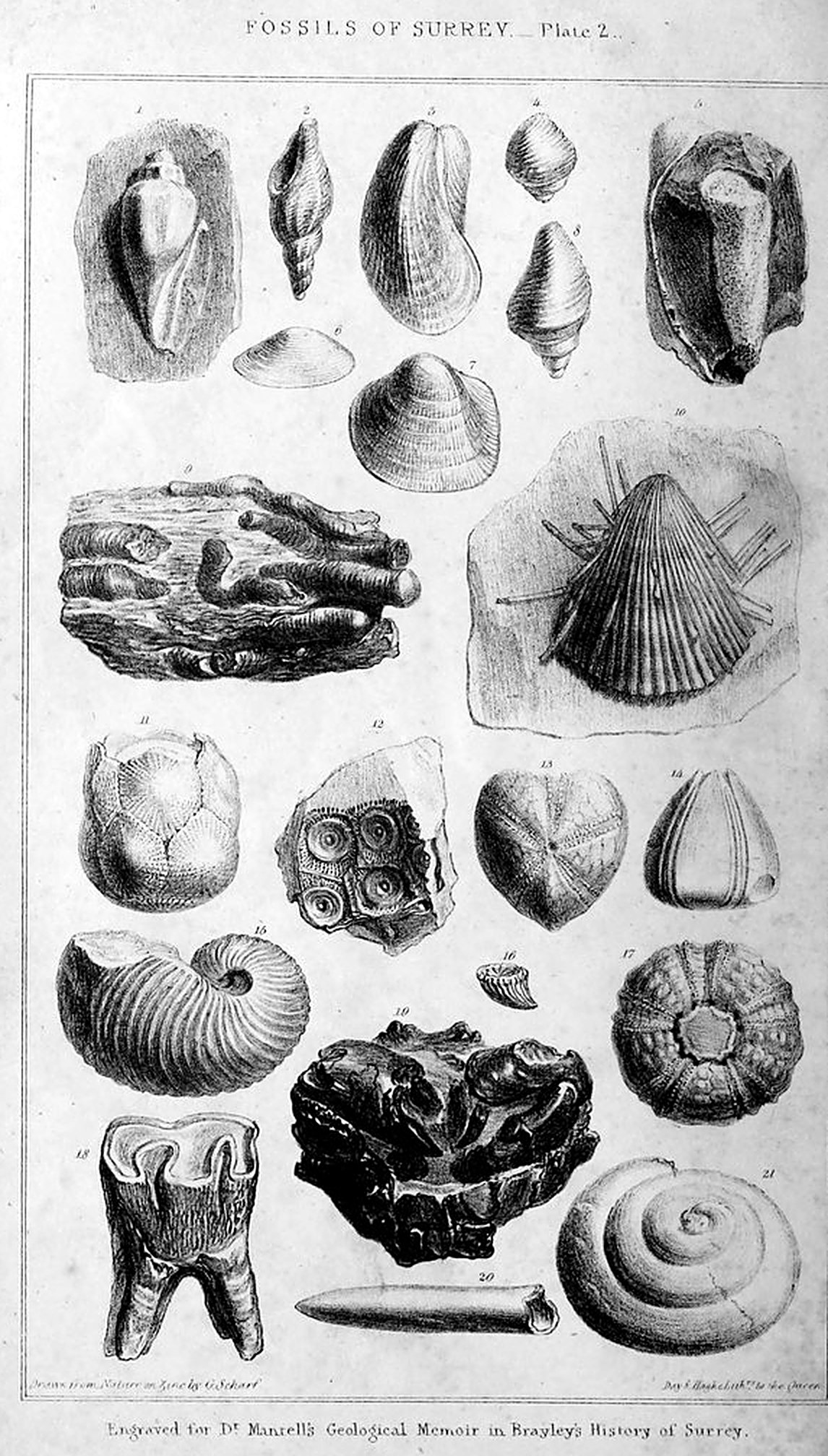
1. Voluta musicalis imbedded in indurated clay: a fragment of a septarium from Wandsworth common; in the cabinet of Miss Henrietta Wollaston. Figs. 2, 3, 4, 6, 7, 8, 9, 16, and 19, are also from the same locality, and preserved in the select collection of Miss H. Wollaston.
2. Murex trilineatus: many specimens of this species were found at Wandsworth common.
3. Modiola elegans: both valves are preserved in this specimen, which is somewhat distorted by compression.
4. Conus: too imperfect to determine the species.
5. A branched silicified Sponge in flint: from Clapham common.
6. Nucula: a very delicate shell, of which but two or three specimens were found.
7. Cardium semi-granulatum: several examples of this beautiful shell were collected.
8. Pleurotoma: many specimens were met with, but none perfect.
9. Wood, perforated by Teredines, in which the tubes of the shells are filled up by pyrites: drawn from a portion of a very large mass.
10. Plagiostoma (spondylus) spinosum: from the chalk near Croydon.
11. Marsupites Milleri: from the chalk of Mickleham downs.
12. Impression of part of the shell of a Cidaris (or tuberculated echinus) in flint: from the gravel of Clapham common.
13. Silicious cast of an echinus (spatangus): from the gravel of Clapham common.
14. —————— (conulus): from the gravel of Wandsworth common.
15. Nautilus elegans: from the grey marl near Merstham.
16. Turbinolia (a fossil coral): from the clay of Wandsworth common.
17. Silicious cast of a tuberculated echinus (cidaris): from the gravel of Clapham common.
18. Grinding tooth of a Rhinoceros: found in post-tertiary gravel on Petteridge common.
19. Fossil Crab (Cancer Leachii): from the London clay near Richmond.
20. Belemnite: from the chalk, Croydon.
21. Cirrus (a spiral univalve shell): from the chalk, Croydon.
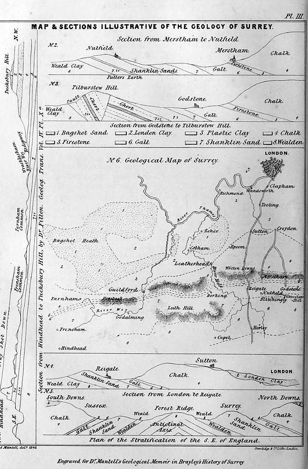
No. 1.—Section from Hindhead to Tucksbury-hill, in the western extremity of the county: the strata are inclined to the north-west. (From Dr. Fitton’s Memoir, Geol.
[168] Trans. vol. iv.) This interesting section comprises the entire series of strata from the Bagshot sand to the weald clay inclusive, viz.—
1. Bagshot sand, capping Tucksbury-hill.
2. London clay.
3. Plastic clay.
4. Chalk.
5. Firestone.
6. Galt.
7. Shanklin sand: the three divisions of this group of sands and clays are here well marked, and are designated by the figures, 7, the uppermost division; 7 x, the middle or argillaceous group; and 7 xx, the lowermost.
8. The Wealden strata.
No. 2.—Section from Merstham to Nutfield. The firestone appears (or, in geological language, crops out,) at the foot of the downs, at the village of Merstham; at Nutfield, the situation of the Fuller’s earth is shewn.
No. 3.—Section from the Chalk hill, north of Godstone, to Tilburstow-hill. The firestone, galt, and Shanklin sand, appear in succession, as in the section above described; the principal interest in this sketch is the fault, or dislocated beds of sandstone and chert, at Tilburstow-hill.
No. 4.—Section from London to Reigate. This sketch illustrates the position of the London clay in a basin, or depression, of the chalk (2); and the structure of the country around Reigate. One of the Brighton roads passes along this line, traversing the London clay from the Elephant and Castle, by Clapham, Tooting, &c. to near Sutton, and over the chalk downs, with occasional patches of gravel and plastic clay. Descending the bold escarpment of the chalk, the road next passes over the firestone, galt, and upper and middle beds of the Shanklin sands, to Reigate. The lowermost sands form Cockshut-hill; and in the valley beyond, the weald clay appears.
No. 5.—Plan of the stratification of the south-east of England. This hypothetical section is intended to explain the succession and direction of the strata in Surrey and Sussex. The deposits of Sussex dip towards the S. E.; and those of Surrey, to the N. W.: an elevation of the wealden formation, constituting an anticlinal axis, having broken through the overlying rocks, and thrown them into their present position.
No. 6.—Geological Map of Surrey. Upon so small a scale, an illustration of the general distribution of the strata which rise to the surface in this county, can alone be attempted.
On the north, the tertiary strata, which cover the chalk, are seen to occupy the whole of that division of the county; and are succeeded on the south by the North downs, which appear rising from beneath the London and plastic clay. A narrow belt of firestone and galt flanks the foot of the downs; the Shanklin or green sand next appears; and lastly, the clays, limestones, and sands, of the Wealden.
Mr. Greenough’s Geological Map of England and Wales should be consulted by those who require more detailed information on the subject.
1 The rivers of Surrey, are the Wey, the Mole, and the Wandle, all of which flow into the Thames, and demand no particular notice from the geologist, except, perhaps, to observe that the Mole, from the cavernous nature of the strata over which it flows, occasionally disappears in some parts of its course; and in seasons of drought its channel, in several places, is quite dry.
2 Young’s Agricultural Survey.
3 Manning and Bray’s History of Surrey, vol. iii.
4 Woodward, in the early part of the eighteenth century, had collected numerous fossils from the chalk and London clay of Surrey. In his Natural History of Fossils, (London, 1729,) he frequently refers to localities in this county. Chalk-pits near Croydon and Reigate appear to have afforded him a great number of the usual cretaceous shells, corals, and belemnites; and the clay-pits at Richmond, (the area which they occupied is now covered with buildings,) abundance of nautili, septaria, with shells, wood, fossil resin, and other organic remains of the London clay.
5 The following notices relating to the geology of Surrey have appeared in the Transactions of the Geological Society of London.
On the strata lying over the chalk; by Thomas Webster, esq.; Geol. Trans. vol. ii. p. 198, 224.
On the geognostical situation of the Reigate stone, and of the Fuller’s earth at Nutfield; by Thomas Webster, esq. Secretary of the Geological Society of London; vol. v. p. 353.
On the Bagshot sand; by Henry Warburton, esq.; vol. i. second series, p. 47.
On the blue chalk-marl of Bletchingley; by G. A. Mantell, esq.; vol. i. second series, p. 421.
6 1. The Fossils of the South Downs, or Illustrations of the Geology of Sussex: 1 vol. 4to. 1832. Vide pp. 81, 135, 295, &c. The fossils figured in this work occur, for the most part, also in the corresponding strata of Surrey.
2. The Fossils of Tilgate Forest; 1 vol. 4to. 1827. Vide pp. 14, 19, 22.
3. The Geology of the south-east of England; 1 vol. 8vo. 1833; pp. 67, 164, 167, 177.
4. The Wonders of Geology, or a familiar exposition of geological phenomena; 2 vols. 8vo. 4th edition, 1840. Vide vol. i. p. 341, et seq.
7 Outlines of the Geology of England and Wales; by Messrs. Conybeare and Phillips; 1 vol. 8vo. 1822. Vide pp. 50, 81. 150, &c.
8 Observations on some of the Strata between the chalk and the Oxford oolite in the south-east of England; by W. H. Fitton, M.D.; Geolog. Trans. vol. iv. second series, p. 103.
9 The line of subterraneous movement by which the secondary and tertiary strata of the south-east of England have been thrown into hills and vallies, appears to have ranged nearly east and west from the vale of Pewsey in Wiltshire, by Kingsclere, Farnham, and Guildford; traversing the wealds of Kent and Sussex, and extending to the opposite coast of France near Boulogne. There can be no doubt, that all the members of the chalk formation in Surrey and Sussex, now separated by the elevated ridge of the weald, were once continuous, and spread over the whole area of the south-east of England at present occupied by the wealden.
10 See Wonders of Geology, 4th edition, vol. i. p. 120.
11 Oper Cit. p. 138.
12 Id. p. 145.
13 Geology of the South-east of England, p. 33.
14 Wonders of Geology, vol. i. p. 324.
15 Id. p. 213.
16 Conybeare and Phillips’s Geology of England, p. 14.
17 Geological Transactions, vol. i. p. 49.
18 Mr. Warburton mentions casts of a crasatella, pecten, and trochus.
19 This sandstone is of a saccharine structure, and may be considered as a peculiar crystallization, rather than the detritus of other rocks.
20 History of Epsom, p. 60.
21 After common salt is extracted from sea-water, the residue contains sulphate and muriate of magnesia; the latter is decomposed by suphuric acid. The fine capillary incrustation so common on the damp walls of new buildings in which sea-sand has been used, is sulphate of magnesia.
22 These fossils have been described by Dr. Buckland in a Notice read before the Geological Society of London. Proceedings of the Geol. Soc. vol. ii. p. 687.
23 Septaria (or Ludus Helmontii, as they were fantastically named by the naturalists of that period,) are mentioned by Dr. Woodward, as having been dug up in the clay-pits at Richmond, and in the tile clay-pit at Norwood, about a mile from Croydon. Natural History of Fossils, p. 90.
24 A well sunk on Clapham common, near the residence of the writer, passed through two hundred feet of blue clay to a bed of sand with numerous shells, from which a constant supply of water has been obtained. I am indebted to Peter Blackburn, esq. of Clapham common, for this information.
25 See Wonders of Geology, vol. i. p. 221.
26 Geology of the South-east of England, p. 61.
27 Mr. Middleton.
28 This rock is employed, in the neighbourhood of Bromley, for ornamental work in walls and grottoes.
29 I am indebted to Mr. P. Martin, jun. of Reigate, for specimens.
30 See Phillip’s Treatise on Geology, vol. i. p. 256, for a catalogue of the mammalian remains in tertiary strata.
31 Wonders of Geology, vol. i. pp. 216, 228, 241.
32 Sowerby’s Mineral Conchology, vol. i. pl. 1. This beautiful work contains numerous figures of the fossil shells of the London clay.
33 This species, under the name of Nautilus Græcorum, is described by Dr. Woodward as being dug dup up “in the clay-pit at Richmond sixty feet deep:” and another in a well at Kennington gravel-pits, one hundred and fourteen feet deep, with many other shells, in a bed of blue clay.
34 A beautiful and highly-interesting work on the fossil seed-vessels of Sheppey is in progress of publication, by Mr. Bowerbank; with illustrations by Mr. Sowerby.
35 Natural History of Fossils, p. 168. Dr. Woodward has numerous references to Richmond Park, as a locality for fossils. Nat. Hist. Fossils of England, 2 vols. 8vo. 1729. See vol. ii. pp. 24, 100.
36 Conybeare and Phillips, p. 86.
37 Mr. Middleton. Occasional outbursts of springs from the chalk-vallies, after very wet summers, occur at Epsom, at Smitham-bottom near Croydon, and at Nonsuch park; they are termed the “Earth-bourns” in Surrey.
38 The district occupied by the firestone in Hampshire is described in White’s Natural History of Selbourne: in the west of Sussex, by Mr. Murchison (Geol. Trans. vol. 2): through Sussex to Southbourne, by the Author, in the Geology of the South-east of England: and through Kent, by Dr. Fitton, Geol. Trans. vol. 4.
39 Geological Transactions, vol. v. p. 354.
40 Natural History of Fossils, p. 16.
41 Geological Transactions, vol. v. p. 355.
42 Oper. cit.
43 Ib. second series, vol. iv. p. 137.
44 Geological Transactions, second series, vol. iv. p. 140.
45 Conybeare and Phillips, p. 151.
46 Geological Transactions, vol. iv. p. 140.
47 Notice on the Blue Chalk Marl of Bletchingley in Surrey. Geol. Trans. vol. i. second series, p. 421.
48 Annals of Philosophy: 1817.
49 See “Observations on some of the Strata between the Chalk and the Oxford Oolite in the South-east of England, by William Henry Fitton, M.D. F.R.S. &c.” Geol. Trans. second series, vol. iv. pp. 104—388.
50 The section is reduced one-half from Dr. Fitton’s Pl. X. No. 4.
51 The inclined strata of Tilburstow-hill were described and figured in the “Fossils of Tilgate Forest:” 1827.
52 Dr. Fitton’s Memoir; written in 1828.
53 In a visit to Nutfield, in 1826, I was fortunate in obtaining specimens of this kind of great rarity and beauty, and which are still preserved in my collection in the British Museum.
54 Extract from a Letter to the Author, by William Constable, esq.; 1839.
55 Wonders of Geology, vol. i. p. 342.
56 This cave is an artificial excavation, which is now entered from the castle-mount; it descends, for about two hundred feet, in a direction towards the town, with a vault branching off to the west, one hundred and fifty feet: the width and height are from ten to twelve feet.
57 See Geol. Trans. vol. iv. new series, Pl. XV.
58 Conybeare and Phillips, p. 154.
59 Consult Dr. Fitton’s Memoir, p. 142, et seq.
60 Dr. Fitton, Oper. cit.
61 Mr. Murchison, Geol. Trans. vol. ii. second series, p. 101.
62 A kind of iron ore.
63 The above extracts, from the valuable labours of Dr. Fitton, will serve to convey a general idea of the interesting structure of this part of Surrey; but the reader should refer to the original Memoir, which is a model of sagacious, patient, and successful research. See Geol. Trans. vol. iv. new series.
64 The attention of the reader unversed in geological investigations may be directed to the first appearance of the ammonite, or snake-stone, in the upper beds of the chalk. No traces of this genus of multilocular shell have been found in any of the strata newer than the chalk: the animal appears to have become extinct at this epoch: in the older rocks, several hundred species occur.
65 See Wonders of Geology, 4th edit. vol. i. p. 306.
66 Conybeare and Phillips, p. 169.
67 The extent of the wealden deposits in Sussex, and the favourable circumstances in which the writer was placed for their examination, led to the important knowledge of the fresh-water or fluviatile origin of the formation, and the discovery of the iguanodon, hylæosaurus, and other colossal reptiles. The reader should consult The Fossils of Tilgate Forest, 1 vol. 4to. 1827: and The Wonders of Geology, 4th edition, vol. i. p. 347, et seq.
68 Wonders of Geology, vol. i. p. 380.
69 Extract from a Letter from W. Constable, esq. to the Author: 1839.
70 Dr. Fitton’s Memoir, p. 148, et seq. The geological structure of the adjacent parts of Hants and Sussex has been admirably sketched by my friend, Peter J. Martin, esq. of Pulborough, in his “Geological Memoir on a part of Western Sussex;” 1 vol. 4to.; 1828.
71 In Surrey, as in Sussex, the occurrence of lignite has given rise to an expensive and abortive search for coal. In Aubrey’s History of Surrey there is an amusing account of the digging and boring for coal at Slyfield, by Mr. Giles Thornborough, rector of the Holy Trinity at Guildford. After digging and boring through beds of “sand, gravel, clay, and rock-stone, with cockle shells, and perriwinkle shells,” they reached a bed of coal, “the depth of which was unknown; for here the irons broke, thought by Mr. William Lilly the astrologer, to be by subterranean spirits; for as fast as the irons were put in, they would snap off.”—(Aubrey’s Hist. of Surrey, vol. iii.) Jet is, also, stated to have been found in the parish of Wotton.
72 See Wonders of Geology, vol. i. p. 399.
73 These specimens may now be seen in my collection, in the gallery of Organic Remains, of the British Museum.
74 Hylæosaurus; this term signifies wealden-lizard: the derivation of the word Weald is from the Saxon, Wald, a wood or forest.
75 See Wonders of Geology, vol. i. p. 408.
Transcribed by Philip Boys, with Claude, October 2026. Build 1.