Build 1 — 30 Jul 2026
By Keith Bailey. First published in the Wandsworth Historical Society's Paper 13, December 1975, pp.12–13. Reproduced here with the kind permission of the author. OCR clean-up and transcription by Claude (Anthropic).
[Editorial note: the scanned original supplied for this transcription begins part-way through the footnotes of a different, preceding article in the same Wandsworth Historical Society paper — concerning Putney rather than Battersea. Those footnotes (numbered 4–8) are reproduced below for completeness, since they appear on the same page of the source, but they are not part of Keith Bailey's article, which follows after the second horizontal rule.]
4. Henry White was born in Putney c.1584, and was a baker. Under the Commonwealth he became Sheriff of Surrey, despite pleading illhealth and being aged about 70. He died in 1658.
5. The Smith family farmed 15 acres as well as running the "Queens Arms". Two brothers, Matthias and Stephen, had inherited the land and appurtenances from their father, also Matthias, who died in 1608.
6. The phraseology here suggests that Rowland Lacy, presumably the son of John Lacy who had entertained Elizabeth I in Putney, had recently demolished and rebuilt the "Palace".
7. This wharf was first mentioned in 1604 and was used for the import of manure from London, presumably for local market gardens. It lay on the Putney Gutter, just by the boundary with Wandsworth. The site allows the prevailing winds to carry any offensive odours into the adjacent parish!
8. Local legends have said that this was once the home of Walter Cromwell and the birthplace of Thomas, largely on the grounds that the former was inter alia a smith. He was also recorded as a brewer, however, and could equally have lived at the Brewhouse by the Thames.
Most of the records relating to estate management and agricultural practices which survive for the Wandsworth area tend to concern the larger estates, or even whole manors. In any case, such records in this area are scarce during most periods of our history, and it is very unusual to have any information on a small farm. Amongst the archives deposited at the Greater London Record Office, however, there is a plan and associated description of "Mr Harman's Estate at Battersea-Rise", by T Davey, dated 1773 (1).
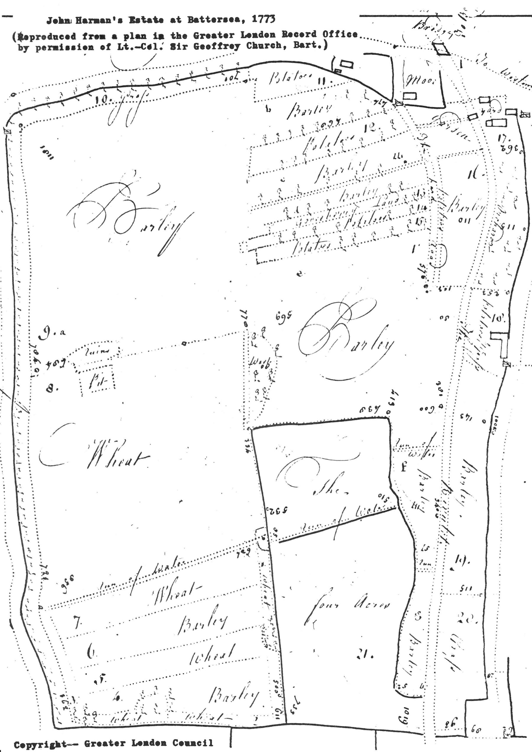
Harman's was a small estate lying astride the Falcon Brook just south of Battersea Rise, with most of the land on the western slope of the valley as far as Five Houses Lane (now Bolingbroke Grove) on the edge of what is now Wandsworth Common. The plan (of which most is reproduced to illustrate this note) shows that the farmhouse lay in the north-east corner, just about where Northcote Road is today. The difference in altitude between the valley floor and the highest part of the farm is about 55 ft., and the underlying geology is alluvial (in the valley bottom), London Clay (the whole valley side-slope), and Taplow river gravel (a small area along the western fringe and in the area now occupied by Battersea Cemetery).
Davey's survey gives details of the land use in 1773, and reveals a complex pattern of cropping, interwoven with pastures and wastes. The total area was about 31.5 acres, of which 6.1 acres was sown with wheat (19%) in six separate areas, 14.1 acres (45%) was sown with barley in 11 different parcels, and 1.2 acres (4%) was sown with potatoes in four small lots. The farmyard, orchard and garden occupied about one acre. Most of the rest was grassland for pasture. Several small streams drained eastwards across the estate to the Falcon Brook. In view of the clayey nature of most of the soil, the predominance of barley is not surprising.
The most interesting feature of the pattern of land use is to be found in the north-east, just by the farmhouse itself. Despite the fact that the area is clearly wholly enclosed and owned by one man, the crops in this area are sown in narrow parallel strips about 160 yards long. Apart from the Gooseberry Land, whose use is not stated, this area is given over to potatoes and barley, and the strips are clearly derived from regular quarter- and half-acre sizes, as one would expect in an open-field situation. Whether this represents a legacy from open-field farming in south Battersea cannot yet be ascertained, although there seems to be no reason for deliberately dividing up a field held in severalty (2) into small strips for different crops.
The strip pattern recurs in the south-west of Harman's estate, where there are alternating three-quarter and half-acre strips of wheat and barley, separated by a run of water from a much larger four acre field all sown with wheat. A glance at the map will show a narrow strip running at right-angles to lots 4–7 in this area. It is sown with wheat, but is clearly suggestive of a headland — on which the plough was turned in open-field farming. Perhaps we have two relics of open field on this estate, and it is to be hoped that future research will throw some more light on the subject.
John Harman's Estate at Battersea, 1773. Reproduced from a plan in the Greater London Record Office, by permission of Lt.-Col. Sir Geoffrey Church, Bart. Copyright — Greater London Council.
Having looked at the cropping arrangements for 1773, a little of the estate's background history is necessary. This information has been derived from the Battersea Poor Rate assessments (3). These were made twice a year and enable one to trace changes in ownership. John Harman is only mentioned between October 1771 and March 1775, and the survival of the 1773 survey is therefore a piece of good fortune for local historians.
The earlier and later history of this small corner of Battersea is more complicated, for it was usually in two discrete ownerships. Thus, from July 1760 until October 1767, parts of this land were owned by Moses Hill and Henry Monger. By February 1768, however, they had been merged under Henry Monger, which arrangement lasted for a couple of years. In April 1770, Hill's former land had been taken over by a Mr Hoare, Monger reverting to his smaller holding.
In October 1771, John Harman appears in the assessment in place of Hoare. Monger in turn appears for the last time in April 1772, and from October 1772 until March 1774 Harman held both estates. The total rental value was estimated at £64 (about £2 per acre) — Hill's portion being £28 and Monger's £36. By March 1775, Hill's portion had changed hands yet again, and was owned by Jonathan Church, who had also replaced Harman on the rest of the estate by September of the same year.
The constant changes in ownership over this short period of fifteen years suggest that few of those involved were resident locally, rather using the land for investment purposes. Moses Hill does seem to have been a farmer, however, and his name is remembered in 1773 in "Hill's Green" (lot 18) on the east bank of the Falcon Brook. A building, together with a gate leading onto a track suggests that this was his farmhouse.
In view of the close proximity to the main farm, and the lack of a clear east-west boundary dividing the two parts of John Harman's estate, it may be that the lands were intermingled, and that this is the reason for the persistence of strips (see above), although this does not explain why the rest of the land is comprised of more or less regular enclosures.
Keith Bailey
1. GLRO E/BOL/16 and 17.
2. That is in the possession of one man, as opposed to communally.
3. 1760–1778, Battersea District Library.
I should like to thank the staff at the Greater London Record Office for their help in obtaining copies of the documents upon which this note is based.
Wandsworth Historical Society, Paper 13, December 1975. Reproduced by kind permission of Keith Bailey.<\p>
It would be good to have a really sharp version of the Harman plan. Claude suggested contacting the London Archives, but it would be £20 to ask the question, plus whatever they say is the cost of the reprographics:
Request regarding a reproduction of E/BOL/016 and E/BOL/017 (Bolingbroke estate papers)
Dear Sir or Madam,
I am researching the history of Battersea Rise for a local history website (historyofwandsworthcommon.org), and would like to ask about two items in your Bolingbroke (Lord) collection:
E/BOL/016 — Particulars of estate and plan, Mr Harman, Battersea Rise, 1773
E/BOL/017 — Particulars of estate and plan, Mr Harman, Battersea Rise, 1773
Both documents are cited in Keith Bailey's short article "A Small Battersea Estate in the 1770s" (Wandsworth Historical Society, Paper 13, December 1975), which includes a rather low-resolution photocopy of the accompanying plan, reproduced by kind permission of the late Lt.-Col. Sir Geoffrey Church, Bart. I am hoping to have a copy of all of the particulars but , depending on cost, especially a sharper image of the same plan.
Could you kindly let me know:
whether a digital scan or photograph of either item already exists; if not, whether your reprographics service could produce one, and at what cost; whether I need to register for a History Card, or view the item in person, before a copy can be ordered.
Thank you very much for your help.
Yours faithfully,
Philip Boys
philip.boys@btinternet.com
harman-battersea-estate-1773-map.jpeg