The History of Wandsworth Common
Home › Building histories › The Metamorphosis of Battersea › Appendix 6
Appendix 6
Battersea Estate Directory by Group
Build 2 — 24 September 2026
Keith Alan Bailey (1995)
Contents
– Type 1a – Original Resident Owner
– Type 1b – Original Absentee Owner
– Type 2a – Secondary Resident Owner
– Type 2b – Secondary Absentee Owner
– Type 3 – Architect/Surveyor
– Type 4 – Builder
– Type 5 – Legal Professions
– Type 6 – Other Occupations
– Type 7 – Local Authority
– Type 8 – Freehold Land Companies
– Type 9 – Dwellings Companies
– Type 10 – Charity
– Composite Types
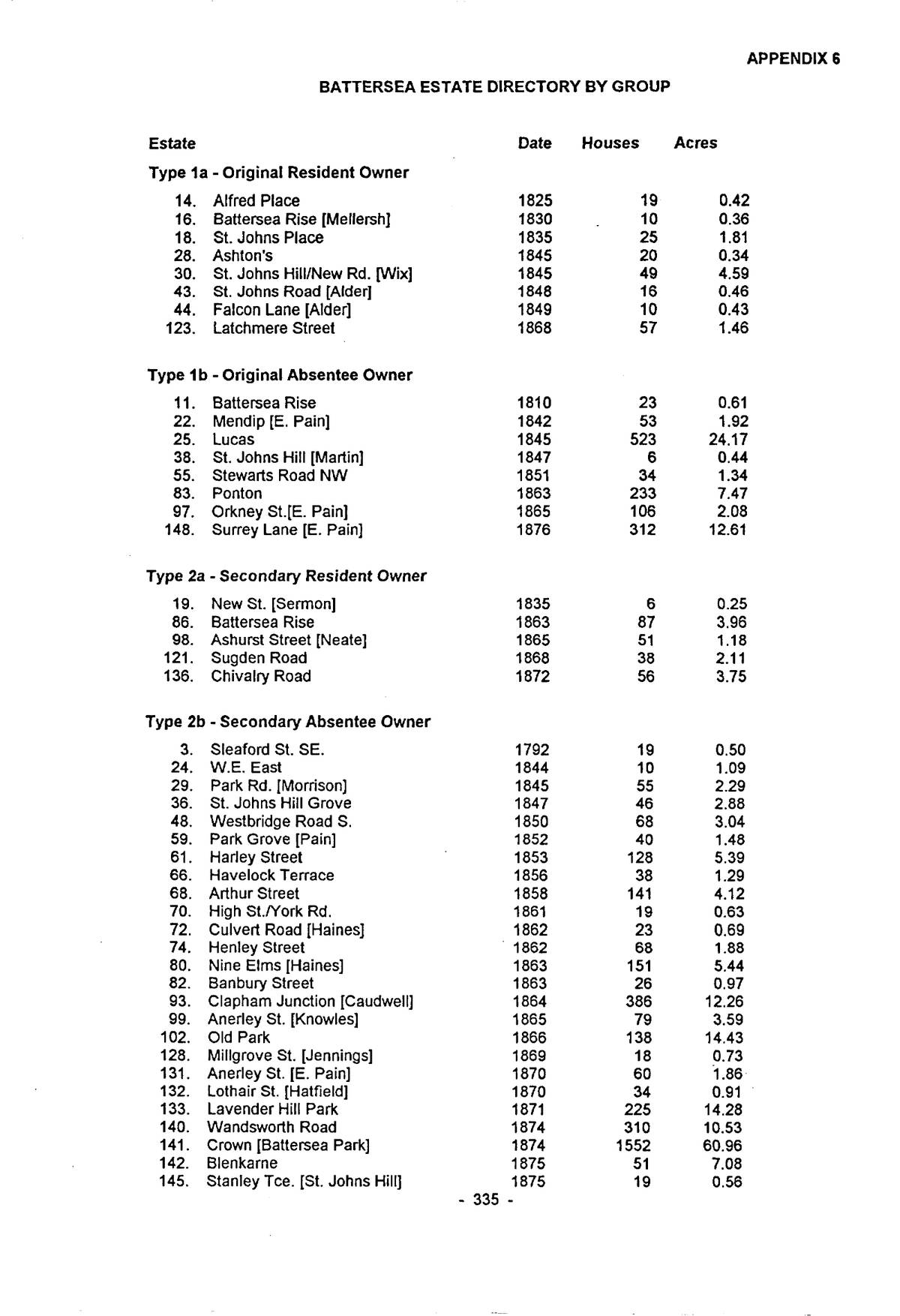
p. 335Type 1a – Original Resident Owner
| Estate | Date | Houses | Acres |
|---|
| 14. | Alfred Place | 1825 | 19 | 0.42 |
| 16. | Battersea Rise [Mellersh] | 1830 | 10 | 0.36 |
| 18. | St. Johns Place | 1835 | 25 | 1.81 |
| 28. | Ashton’s | 1845 | 20 | 0.34 |
| 30. | St. Johns Hill/New Rd. [Wix] | 1845 | 49 | 4.59 |
| 43. | St. Johns Road [Alder] | 1848 | 16 | 0.46 |
| 44. | Falcon Lane [Alder] | 1849 | 10 | 0.43 |
| 123. | Latchmere Street | 1868 | 57 | 1.46 |
Type 1b – Original Absentee Owner
| Estate | Date | Houses | Acres |
|---|
| 11. | Battersea Rise | 1810 | 23 | 0.61 |
| 22. | Mendip [E. Pain] | 1842 | 53 | 1.92 |
| 25. | Lucas | 1845 | 523 | 24.17 |
| 38. | St. Johns Hill [Martin] | 1847 | 6 | 0.44 |
| 55. | Stewarts Road NW | 1851 | 34 | 1.34 |
| 83. | Ponton | 1863 | 233 | 7.47 |
| 97. | Orkney St.[E. Pain] | 1865 | 106 | 2.08 |
| 148. | Surrey Lane [E. Pain] | 1876 | 312 | 12.61 |
Type 2a – Secondary Resident Owner
| Estate | Date | Houses | Acres |
|---|
| 19. | New St. [Sermon] | 1835 | 6 | 0.25 |
| 86. | Battersea Rise | 1863 | 87 | 3.96 |
| 98. | Ashurst Street [Neate] | 1865 | 51 | 1.18 |
| 121. | Sugden Road | 1868 | 38 | 2.11 |
| 136. | Chivalry Road | 1872 | 56 | 3.75 |
Type 2b – Secondary Absentee Owner
| Estate | Date | Houses | Acres |
|---|
| 3. | Sleaford St. SE. | 1792 | 19 | 0.50 |
| 24. | W.E. East | 1844 | 10 | 1.09 |
| 29. | Park Rd. [Morrison] | 1845 | 55 | 2.29 |
| 36. | St. Johns Hill Grove | 1847 | 46 | 2.88 |
| 48. | Westbridge Road S. | 1850 | 68 | 3.04 |
| 59. | Park Grove [Pain] | 1852 | 40 | 1.48 |
| 61. | Harley Street | 1853 | 128 | 5.39 |
| 66. | Havelock Terrace | 1856 | 38 | 1.29 |
| 68. | Arthur Street | 1858 | 141 | 4.12 |
| 70. | High St./York Rd. | 1861 | 19 | 0.63 |
| 72. | Culvert Road [Haines] | 1862 | 23 | 0.69 |
| 74. | Henley Street | 1862 | 68 | 1.88 |
| 80. | Nine Elms [Haines] | 1863 | 151 | 5.44 |
| 82. | Banbury Street | 1863 | 26 | 0.97 |
| 93. | Clapham Junction [Caudwell] | 1864 | 386 | 12.26 |
| 99. | Anerley St. [Knowles] | 1865 | 79 | 3.59 |
| 102. | Old Park | 1866 | 138 | 14.43 |
| 128. | Millgrove St. [Jennings] | 1869 | 18 | 0.73 |
| 131. | Anerley St. [E. Pain] | 1870 | 60 | 1.86 |
| 132. | Lothair St. [Hatfield] | 1870 | 34 | 0.91 |
| 133. | Lavender Hill Park | 1871 | 225 | 14.28 |
| 140. | Wandsworth Road | 1874 | 310 | 10.53 |
| 141. | Crown [Battersea Park] | 1874 | 1552 | 60.96 |
| 142. | Blenkarne | 1875 | 51 | 7.08 |
| 145. | Stanley Tce. [St. Johns Hill] | 1875 | 19 | 0.56 |
p. 336
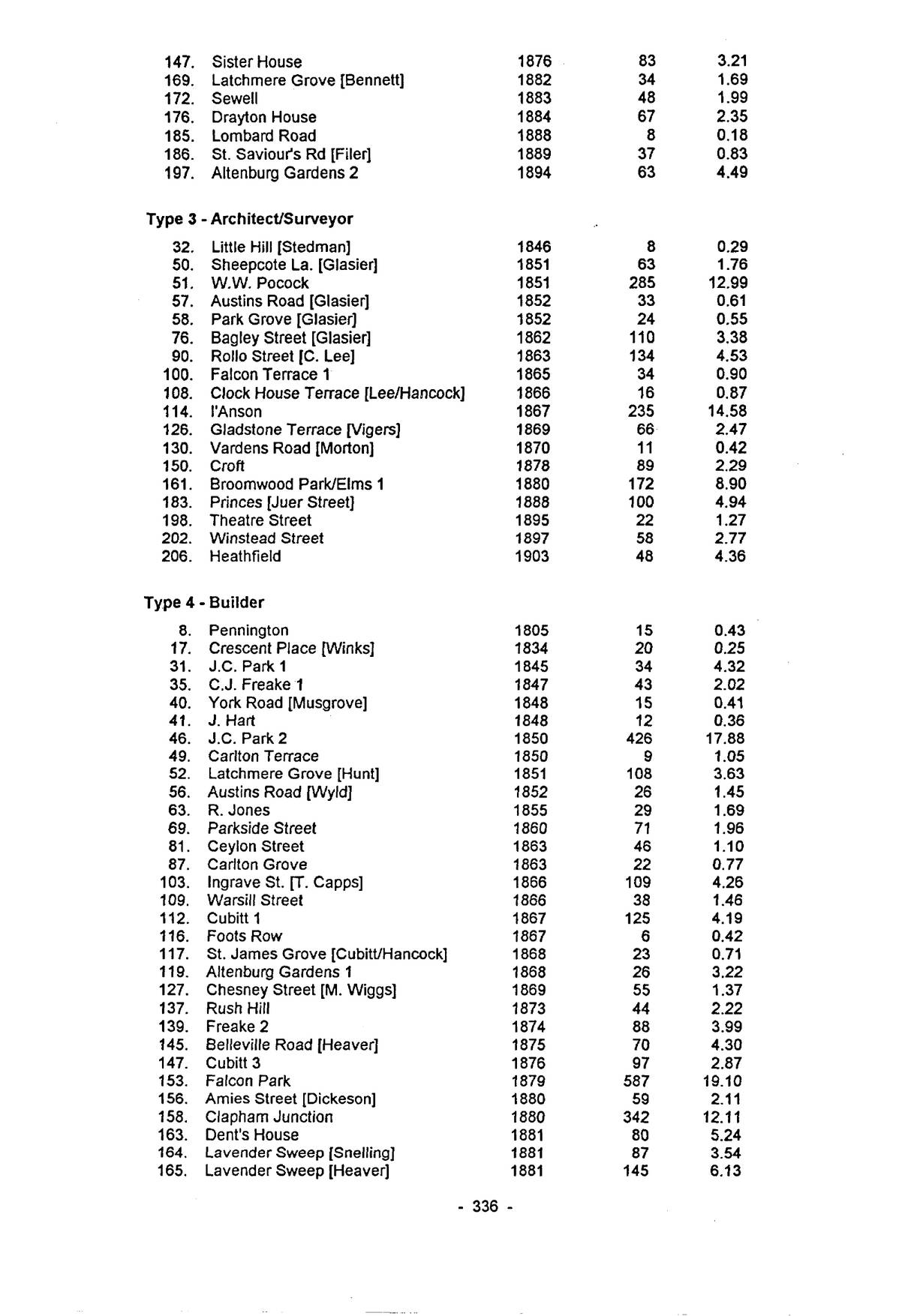
(continued) | Estate | Date | Houses | Acres |
|---|
| 147. | Sister House | 1876 | 83 | 3.21 |
| 169. | Latchmere Grove [Bennett] | 1882 | 34 | 1.69 |
| 172. | Sewell | 1883 | 48 | 1.99 |
| 176. | Drayton House | 1884 | 67 | 2.35 |
| 185. | Lombard Road | 1888 | 8 | 0.18 |
| 186. | St. Saviour’s Rd [Filer] | 1889 | 37 | 0.83 |
| 197. | Altenburg Gardens 2 | 1894 | 63 | 4.49 |
Type 3 – Architect/Surveyor
| Estate | Date | Houses | Acres |
|---|
| 32. | Little Hill [Stedman] | 1846 | 8 | 0.29 |
| 50. | Sheepcote La. [Glasier] | 1851 | 63 | 1.76 |
| 51. | W.W. Pocock | 1851 | 285 | 12.99 |
| 57. | Austins Road [Glasier] | 1852 | 33 | 0.61 |
| 58. | Park Grove [Glasier] | 1852 | 24 | 0.55 |
| 76. | Bagley Street [Glasier] | 1862 | 110 | 3.38 |
| 90. | Rollo Street [C. Lee] | 1863 | 134 | 4.53 |
| 100. | Falcon Terrace 1 | 1865 | 34 | 0.90 |
| 108. | Clock House Terrace [Lee/Hancock] | 1866 | 16 | 0.87 |
| 114. | I’Anson | 1867 | 235 | 14.58 |
| 126. | Gladstone Terrace [Vigers] | 1869 | 66 | 2.47 |
| 130. | Vardens Road [Morton] | 1870 | 11 | 0.42 |
| 150. | Croft | 1878 | 89 | 2.29 |
| 161. | Broomwood Park/Elms 1 | 1880 | 172 | 8.90 |
| 183. | Princes [Juer Street] | 1888 | 100 | 4.94 |
| 198. | Theatre Street | 1895 | 22 | 1.27 |
| 202. | Winstead Street | 1897 | 58 | 2.77 |
| 206. | Heathfield | 1903 | 48 | 4.36 |
Type 4 – Builder
| Estate | Date | Houses | Acres |
|---|
| 8. | Pennington | 1805 | 15 | 0.43 |
| 17. | Crescent Place [Winks] | 1834 | 20 | 0.25 |
| 31. | J.C. Park 1 | 1845 | 34 | 4.32 |
| 35. | C.J. Freake 1 | 1847 | 43 | 2.02 |
| 40. | York Road [Musgrove] | 1848 | 15 | 0.41 |
| 41. | J. Hart | 1848 | 12 | 0.36 |
| 46. | J.C. Park 2 | 1850 | 426 | 17.88 |
| 49. | Carlton Terrace | 1850 | 9 | 1.05 |
| 52. | Latchmere Grove [Hunt] | 1851 | 108 | 3.63 |
| 56. | Austins Road [Wyld] | 1852 | 26 | 1.45 |
| 63. | R. Jones | 1855 | 29 | 1.69 |
| 69. | Parkside Street | 1860 | 71 | 1.96 |
| 81. | Ceylon Street | 1863 | 46 | 1.10 |
| 87. | Carlton Grove | 1863 | 22 | 0.77 |
| 103. | Ingrave St. [T. Capps] | 1866 | 109 | 4.26 |
| 109. | Warsill Street | 1866 | 38 | 1.46 |
| 112. | Cubitt 1 | 1867 | 125 | 4.19 |
| 116. | Foots Row | 1867 | 6 | 0.42 |
| 117. | St. James Grove [Cubitt/Hancock] | 1868 | 23 | 0.71 |
| 119. | Altenburg Gardens 1 | 1868 | 26 | 3.22 |
| 127. | Chesney Street [M. Wiggs] | 1869 | 55 | 1.37 |
| 137. | Rush Hill | 1873 | 44 | 2.22 |
| 139. | Freake 2 | 1874 | 88 | 3.99 |
| 145. | Belleville Road [Heaver] | 1875 | 70 | 4.30 |
| 147. | Cubitt 3 | 1876 | 97 | 2.87 |
| 153. | Falcon Park | 1879 | 587 | 19.10 |
| 156. | Amies Street [Dickeson] | 1880 | 59 | 2.11 |
| 158. | Clapham Junction | 1880 | 342 | 12.11 |
| 163. | Dent’s House | 1881 | 80 | 5.24 |
| 164. | Lavender Sweep [Snelling] | 1881 | 87 | 3.54 |
| 165. | Lavender Sweep [Heaver] | 1881 | 145 | 6.13 |
p. 337
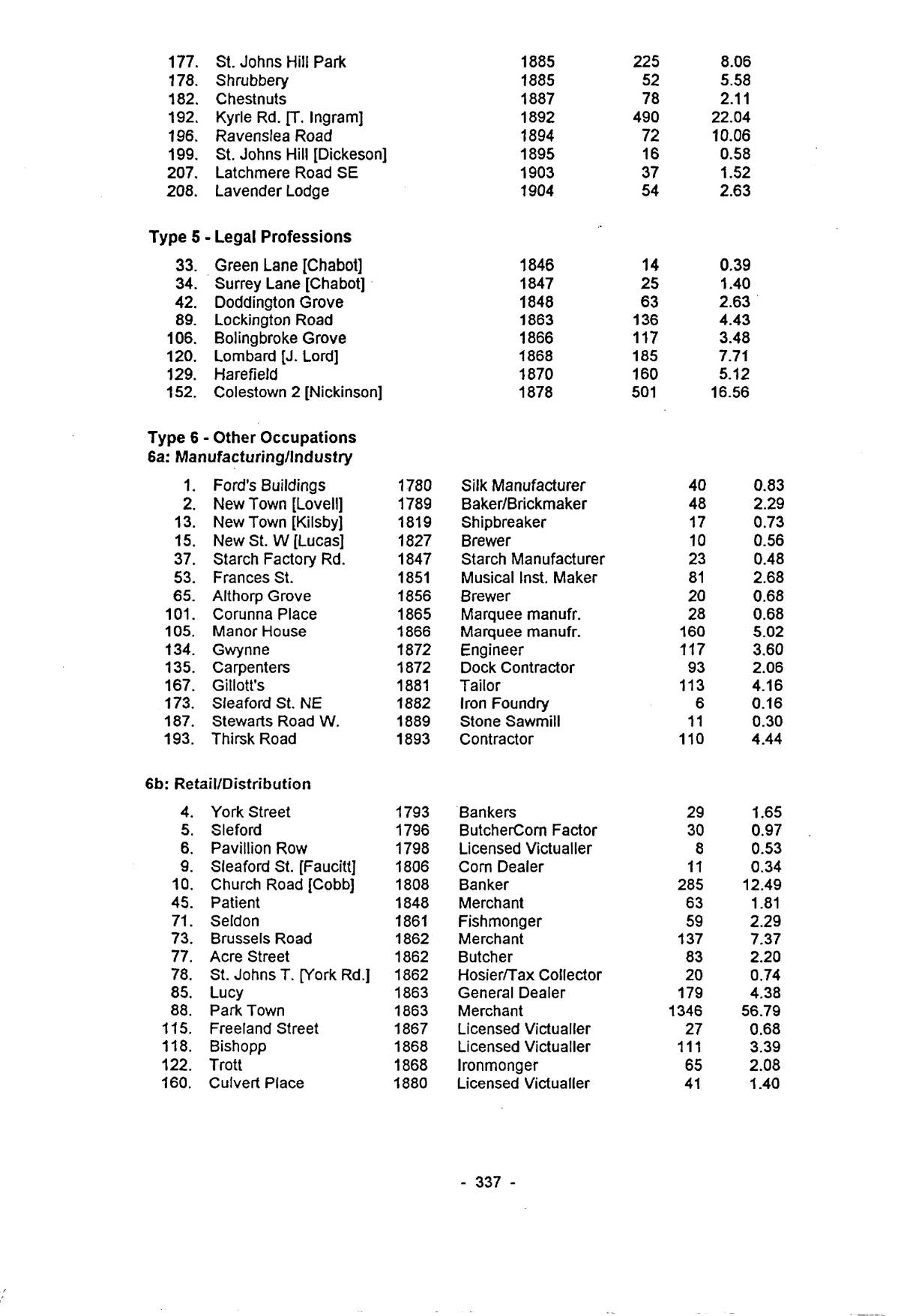
(continued) | Estate | Date | Houses | Acres |
|---|
| 177. | St. Johns Hill Park | 1885 | 225 | 8.06 |
| 178. | Shrubbery | 1885 | 52 | 5.58 |
| 182. | Chestnuts | 1887 | 78 | 2.11 |
| 192. | Kyrle Rd. [T. Ingram] | 1892 | 490 | 22.04 |
| 196. | Ravenslea Road | 1894 | 72 | 10.06 |
| 199. | St. Johns Hill [Dickeson] | 1895 | 16 | 0.58 |
| 207. | Latchmere Road SE | 1903 | 37 | 1.52 |
| 208. | Lavender Lodge | 1904 | 54 | 2.63 |
Type 5 – Legal Professions
| Estate | Date | Houses | Acres |
|---|
| 33. | Green Lane [Chabot] | 1846 | 14 | 0.39 |
| 34. | Surrey Lane [Chabot] | 1847 | 25 | 1.40 |
| 42. | Doddington Grove | 1848 | 63 | 2.63 |
| 89. | Lockington Road | 1863 | 136 | 4.43 |
| 106. | Bolingbroke Grove | 1866 | 117 | 3.48 |
| 120. | Lombard [J. Lord] | 1868 | 185 | 7.71 |
| 129. | Harefield | 1870 | 160 | 5.12 |
| 152. | Colestown 2 [Nickinson] | 1878 | 501 | 16.56 |
Type 6 – Other Occupations
6a: Manufacturing/Industry
| Estate | Date | | Houses | Acres |
|---|
| 1. | Ford’s Buildings | 1780 | Silk Manufacturer | 40 | 0.83 |
| 2. | New Town [Lovell] | 1789 | Baker/Brickmaker | 48 | 2.29 |
| 13. | New Town [Kilsby] | 1819 | Shipbreaker | 17 | 0.73 |
| 15. | New St. W [Lucas] | 1827 | Brewer | 10 | 0.56 |
| 37. | Starch Factory Rd. | 1847 | Starch Manufacturer | 23 | 0.48 |
| 53. | Frances St. | 1851 | Musical Inst. Maker | 81 | 2.68 |
| 65. | Althorp Grove | 1856 | Brewer | 20 | 0.68 |
| 101. | Corunna Place | 1865 | Marquee manufr. | 28 | 0.68 |
| 105. | Manor House | 1866 | Marquee manufr. | 160 | 5.02 |
| 134. | Gwynne | 1872 | Engineer | 117 | 3.60 |
| 135. | Carpenters | 1872 | Dock Contractor | 93 | 2.06 |
| 167. | Gillott’s | 1881 | Tailor | 113 | 4.16 |
| 173. | Sleaford St. NE | 1882 | Iron Foundry | 6 | 0.16 |
| 187. | Stewarts Road W. | 1889 | Stone Sawmill | 11 | 0.30 |
| 193. | Thirsk Road | 1893 | Contractor | 110 | 4.44 |
6b: Retail/Distribution
| Estate | Date | | Houses | Acres |
|---|
| 4. | York Street | 1793 | Bankers | 29 | 1.65 |
| 5. | Sleford | 1796 | Butcher/Corn Factor | 30 | 0.97 |
| 6. | Pavillion Row | 1798 | Licensed Victualler | 8 | 0.53 |
| 9. | Sleaford St. [Faucitt] | 1806 | Corn Dealer | 11 | 0.34 |
| 10. | Church Road [Cobb] | 1808 | Banker | 285 | 12.49 |
| 45. | Patient | 1848 | Merchant | 63 | 1.81 |
| 71. | Seldon | 1861 | Fishmonger | 59 | 2.29 |
| 73. | Brussels Road | 1862 | Merchant | 137 | 7.37 |
| 77. | Acre Street | 1862 | Butcher | 83 | 2.20 |
| 78. | St. Johns T. [York Rd.] | 1862 | Hosier/Tax Collector | 20 | 0.74 |
| 85. | Lucy | 1863 | General Dealer | 179 | 4.38 |
| 88. | Park Town | 1863 | Merchant | 1346 | 56.79 |
| 115. | Freeland Street | 1867 | Licensed Victualler | 27 | 0.68 |
| 118. | Bishopp | 1868 | Licensed Victualler | 111 | 3.39 |
| 122. | Trott | 1868 | Ironmonger | 65 | 2.08 |
| 160. | Culvert Place | 1880 | Licensed Victualler | 41 | 1.40 |
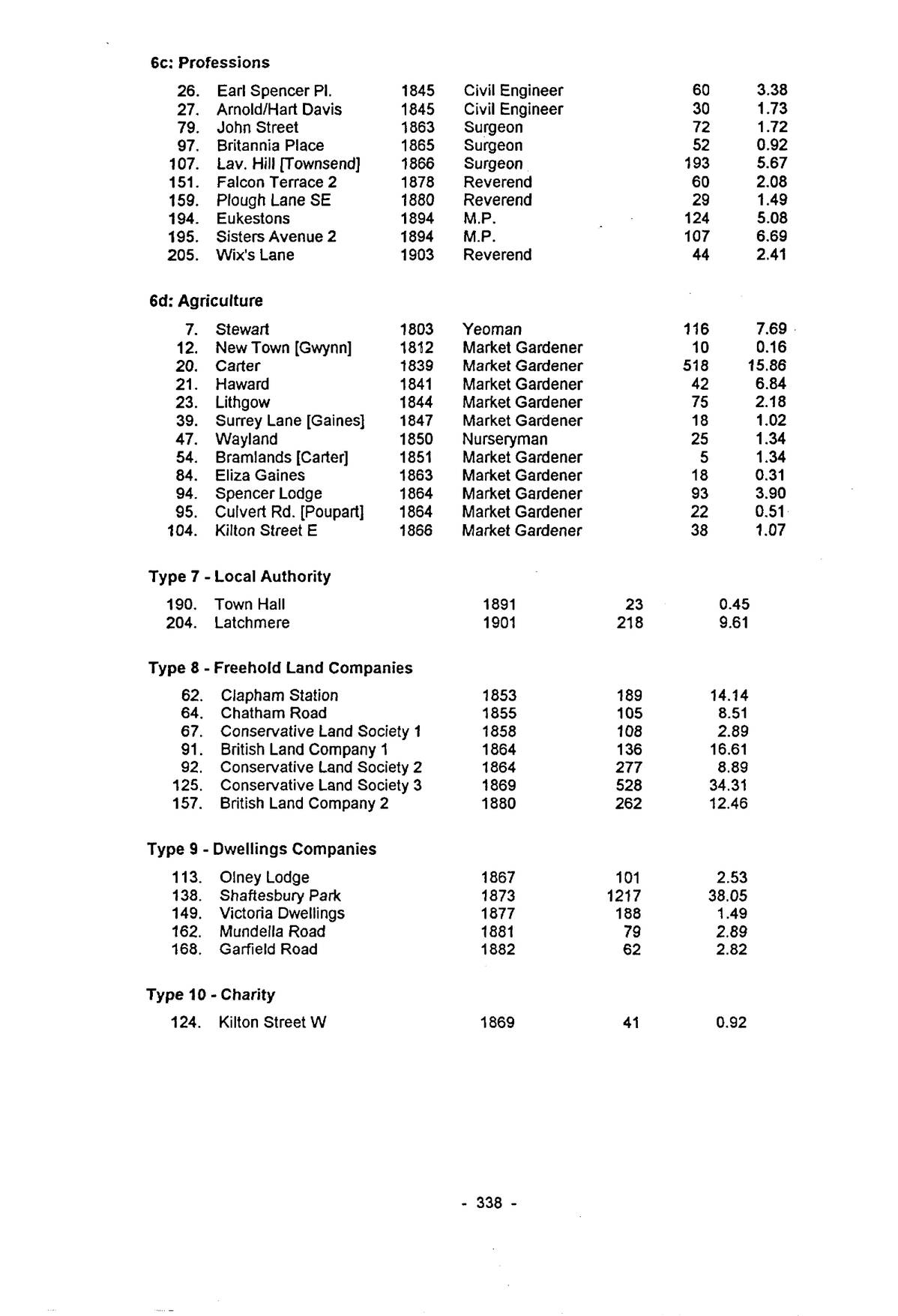
6c: Professions
| Estate | Date | | Houses | Acres |
|---|
| 26. | Earl Spencer Pl. | 1845 | Civil Engineer | 60 | 3.38 |
| 27. | Arnold/Hart Davis | 1845 | Civil Engineer | 30 | 1.73 |
| 79. | John Street | 1863 | Surgeon | 72 | 1.72 |
| 97. | Britannia Place | 1865 | Surgeon | 52 | 0.92 |
| 107. | Lav. Hill [Townsend] | 1866 | Surgeon | 193 | 5.67 |
| 151. | Falcon Terrace 2 | 1878 | Reverend | 60 | 2.08 |
| 159. | Plough Lane SE | 1880 | Reverend | 29 | 1.49 |
| 194. | Eukestons | 1894 | M.P. | 124 | 5.08 |
| 195. | Sisters Avenue 2 | 1894 | M.P. | 107 | 6.69 |
| 205. | Wix’s Lane | 1903 | Reverend | 44 | 2.41 |
6d: Agriculture
| Estate | Date | | Houses | Acres |
|---|
| 7. | Stewart | 1803 | Yeoman | 116 | 7.69 |
| 12. | New Town [Gwynn] | 1812 | Market Gardener | 10 | 0.16 |
| 20. | Carter | 1839 | Market Gardener | 518 | 15.86 |
| 21. | Haward | 1841 | Market Gardener | 42 | 6.84 |
| 23. | Lithgow | 1844 | Market Gardener | 75 | 2.18 |
| 39. | Surrey Lane [Gaines] | 1847 | Market Gardener | 18 | 1.02 |
| 47. | Wayland | 1850 | Nurseryman | 25 | 1.34 |
| 54. | Bramlands [Carter] | 1851 | Market Gardener | 5 | 1.34 |
| 84. | Eliza Gaines | 1863 | Market Gardener | 18 | 0.31 |
| 94. | Spencer Lodge | 1864 | Market Gardener | 93 | 3.90 |
| 95. | Culvert Rd. [Poupart] | 1864 | Market Gardener | 22 | 0.51 |
| 104. | Kilton Street E | 1866 | Market Gardener | 38 | 1.07 |
Type 7 – Local Authority
| Estate | Date | Houses | Acres |
|---|
| 190. | Town Hall | 1891 | 23 | 0.45 |
| 204. | Latchmere | 1901 | 218 | 9.61 |
Type 8 – Freehold Land Companies
| Estate | Date | Houses | Acres |
|---|
| 62. | Clapham Station | 1853 | 189 | 14.14 |
| 64. | Chatham Road | 1855 | 105 | 8.51 |
| 67. | Conservative Land Society 1 | 1858 | 108 | 2.89 |
| 91. | British Land Company 1 | 1864 | 136 | 16.61 |
| 92. | Conservative Land Society 2 | 1864 | 277 | 8.89 |
| 125. | Conservative Land Society 3 | 1869 | 528 | 34.31 |
| 157. | British Land Company 2 | 1880 | 262 | 12.46 |
Type 9 – Dwellings Companies
| Estate | Date | Houses | Acres |
|---|
| 113. | Olney Lodge | 1867 | 101 | 2.53 |
| 138. | Shaftesbury Park | 1873 | 1217 | 38.05 |
| 149. | Victoria Dwellings | 1877 | 188 | 1.49 |
| 162. | Mundella Road | 1881 | 79 | 2.89 |
| 168. | Garfield Road | 1882 | 62 | 2.82 |
Type 10 – Charity
| Estate | Date | Houses | Acres |
|---|
| 124. | Kilton Street W | 1869 | 41 | 0.92 |
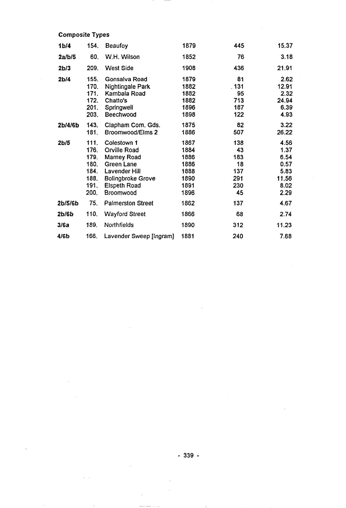
Composite Types
| Type | | Estate | Date | Houses | Acres |
|---|
| 1b/4 | 154. | Beaufoy | 1879 | 445 | 15.37 |
| 2a/b/5 | 60. | W.H. Wilson | 1852 | 76 | 3.18 |
| 2b/3 | 209. | West Side | 1908 | 436 | 21.91 |
| 2b/4 | 155. | Gonsalva Road | 1879 | 81 | 2.62 |
| 170. | Nightingale Park | 1882 | 131 | 12.91 |
| 171. | Kambala Road | 1882 | 95 | 2.32 |
| 172. | Chatto’s | 1882 | 713 | 24.94 |
| 201. | Springwell | 1896 | 187 | 6.39 |
| 203. | Beechwood | 1898 | 122 | 4.93 |
| 2b/4/6b | 143. | Clapham Com. Gds. | 1875 | 82 | 3.22 |
| 181. | Broomwood/Elms 2 | 1886 | 507 | 26.22 |
| 2b/5 | 111. | Colestown 1 | 1867 | 138 | 4.56 |
| 176. | Orville Road | 1884 | 43 | 1.37 |
| 179. | Marney Road | 1886 | 183 | 6.54 |
| 180. | Green Lane | 1886 | 18 | 0.57 |
| 184. | Lavender Hill | 1888 | 137 | 5.83 |
| 188. | Bolingbroke Grove | 1890 | 291 | 11.56 |
| 191. | Elspeth Road | 1891 | 230 | 8.02 |
| 200. | Broomwood | 1896 | 45 | 2.29 |
| 2b/5/6b | 75. | Palmerston Street | 1862 | 137 | 4.67 |
| 2b/6b | 110. | Wayford Street | 1866 | 68 | 2.74 |
| 3/6a | 189. | Northfields | 1890 | 312 | 11.23 |
| 4/6b | 166. | Lavender Sweep [Ingram] | 1881 | 240 | 7.68 |
About this edition
Transcribed from the typescript of 1995 and checked line by line against the page images. Keith Bailey’s wording, spelling and punctuation are kept. Errors made by the scanning software have been corrected silently. The grey page numbers in the margin (e.g. p. 5) give the original page, and can be clicked to see an image of it. Note numbers link to the references and back.
The following obvious typing slips in the typescript have also been corrected: “ButcherCorn Factor” to “Butcher/Corn Factor” (p. 337).
Keith Alan Bailey, The Metamorphosis of Battersea 1800–1914: A Building History, PhD thesis, The Open University, 1995. Digital edition published with the author’s permission; prepared by Philip Boys, 2026. Build 2 — 24 September 2026.
×
![]()