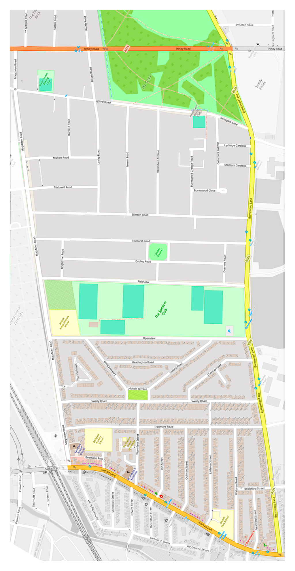
I've rotated the map so that Trinity Road runs East-West to show more clearly the pattern in our streets, and how the layout is almost symmetrical, left and right. There are also patterns in the streetnames.
Last week I wrote about the remarkable pattern in the streets and buildings around us - the rough rectangle between Trinity Road and Garratt Lane, Burntwood Lane and Magdalen Road. I began to think about it while we walked around and around as part of our daily exercise.
There's also a pattern in the names - nearly all have associations with Oxford. Magdalen, Headington, Isis are perhaps more obvious ones, but that led me to find out about other names. And it turns out that so do Ellerton, Tilehurst, Frewin, Routh and many others - even Loxley itself. Some are literal, some are playful, one is tragic.
I've rotated the map so that Trinity Road runs East-West to show more clearly the pattern in our streets, and how the layout is almost symmetrical, left and right. There are also patterns in the streetnames.
How and why did these overall patterns come about?
Because once upon a time nearly the whole area was owned by one person - a very rich widow, Sophia Sheppard (1769/70 - 1848). She inherited most of it from her husband the Reverend Thomas Sheppard, a former Magdalen Fellow and close friend of her brother, Martin Routh (1791-1854), President of Magdalen College.
When her husband died c.1814, Sophia bought and sold various plots round Wandsworth to consolidate her holdings. (She also had land elsewhere in the country, for example Tilehurst in Berkshire.) In the long term, this allowed the development of the area to be planned as a whole, and not piecemeal.
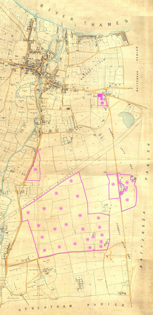
If you want to see the difference having one owner rather than many makes to the subsequent development of an area compare Sophia Sheppard's relatively unified holding with the crazily patched and re-patched "Bridge Field", at the top of the map near the river. This had numerous owners with one or more strips each, seemingly at random. Over time, Bridge Field became the higgledy-piggledy "Tonsleys" and neighbouring streets.
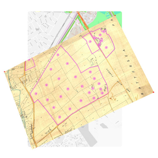
Click on the map a few times to see Sophia Sheppard's land holdings in relation to today's streets. Loxley Road is marked in pink on the modern map.
At the time of her death in 1848 Sophia Sheppard owned even more of Wandsworth east of the Wandle than Earl Spencer. Everything then went to Magdalen College, which was controlled by Sophia's brother, its long-lived President Martin Routh.
After about 1890, the area was gradually developed in phases (and fits and starts) - first, the area near the more industrialised Garrett Lane, and also the "Toast Rack" - originally called "College Park".
It's a fascinating story, but perhaps not one for today.
Here are some local road-names and their likely origins - perhaps you know some more?
A few roads have quite different origins - the top right of our area, for example, was only built up after the three big houses and gardens that once stood there (Burntwood Grange, Burntwood Lodge, and Collamore) were demolished and the land redeveloped in the twentieth century - at different times, hence the inconsistent building styles and road layout.
And there are some local dignitaries - for example Dawnay Rd is named after a Archibald Davis Dawnay, head of an engineering company, elected Mayor of Wandsworth in 1908, who died during his tenth consecutive term in office.
You might like to try your hand at some of the other names - Dorlcote, Freshford, Herondale, Leckford, Lyminge, Nicosia, Sandgate, Waldron.
In short, then, our area is a kind of mirror held up to Oxford in the nineteenth century. And perhaps for that reason, the one person who is not commemorated is Sophia Sheppard herself.
Note: I am indebted to Dr Charlotte Berry, Archivist at Magdalen College, for corresponding with me about Sophia Sheppard, even though the lockdown has closed the Archive and she has very little time available to her to respond to a flood of other people's enquiries.
From Keith Bailey (8 June 2020):
Congratulations on your latest piece, which, of course, prompted me to have a (superficial) dig.
The following seem reasonable explanations:
Dorlcote Mill is the "Mill on the Floss", published 1860. It's where Tom & Maggie Tulliver grew up.
[NB There's a Floss Street in Putney approved 1884, but I know nothing of the development of which is part. No Magdalen link as far as I know.]
Nicosia [and Cyprus!] was acquired by Britain in 1878, 4 years before the street-name was approved.
As for the rest, Freshford is near Bath, Leckford near Stockbridge on R. Test, Sandgate near Folkestone and Waldron near Heathfield in Sussex. The last is also a surname, and possibly some of the others also.
PB:
Yes, I did wonder about Dorlcote Mill, particularly since George Eliot is said to have been writing The Mill on the Floss when she was living in Holly Lodge, 31 Wimbledon Park Road, just over the Wandle from us here - did she choose to live there because of the mills?
[BTW there's an interesting article in the Independent on the "Battle to save George Eliot's unspoilt vista" (17 Nov 2010).]
As you say in your study of Battersea street-names, even when one knows the origin of a name it can be hard to know why it was chosen.
Incidentally, growing up round here there was always confusion about how to pronounce "Nicosia" - people were less travelled then, and had little or no idea of its association with Cyprus. Was it "nick-oh-SEE-yah" or "nick-OH-she-ah"?
PB to KB: 19.8.2020:
One small thing came out of reading the I'Ansons book [Peter Jefferson Smith, The I'Ansons: A Dynasty of London Architects & Surveyors (Clapham Society, 2019)].
.As you pointed out, Cyprus became a British Protectorate in 1879 at about the time the road was laid out. So it was interesting to see (p308) that the Chief Justice for the island was an I'Anson nephew, and Edward I'Anson junior spent 2 months on the island Jan/Feb 1882.
A compelling case, eh?
<< Index: The Hidden History of Our Streets
Please contact me, Philip Boys / 14 Loxley Road, if you have any comments, queries or information to add. And if you want any more of this kind of thing...